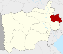
Bang Phae district

Bang Phae บางแพ | |
|---|---|
 District location in Ratchaburi province | |
| Coordinates: 13°41′29″N 99°55′49″E / 13.69139°N 99.93028°E | |
| Country | Thailand |
| Province | Ratchaburi |
| Seat | Bang Phae |
| District established | 1914 |
| Area | |
| • Total | 172.596 km2 (66.640 sq mi) |
| Population (2017) | |
| • Total | 44,768 |
| • Density | 259.38/km2 (671.8/sq mi) |
| Time zone | UTC+7 (ICT) |
| Postal code | 70160 |
| Geocode | 7006 |
Bang Phae (Thai: บางแพ, pronounced [bāːŋ pʰɛ̄ː]) is a district (amphoe) in the eastern part of Ratchaburi province, western Thailand.
History
[edit]The district was created in the year 1914[1] from 17 tambons from the districts Ban Pong, Photharam, and Damnoen Saduak. At first a temporary district office was located in a pavilion of Wat Hua Pho in tambon Hua Pho. Originally named Lam Phraya (ลำพระยา), it was renamed Hua Pho in 1917.[2] In 1939 it was renamed Bang Phae,[3] following the location of the district office since 1918.
Geography
[edit]Neighbouring districts are (from the south clockwise), Damnoen Saduak and Photharam of Ratchaburi Province; Mueang Nakhon Pathom and Sam Phran of Nakhon Pathom province; and Ban Phaeo of Samut Sakhon province.
Administration
[edit]The district is divided into seven sub-districts (tambons), which are further subdivided into 65 villages (mubans). There are two sub-district municipalities (thesaban tambons). Bang Phae covers tambons Bang Phae and Wang Yen, and Pho Hak the tambon Pho Hak. There are a further four tambon administrative organizations (TAO).
| No. | Name | Thai | Pop.[4] |
|---|---|---|---|
| 1. | Bang Phae | บางแพ | 8,246 |
| 2. | Wang Yen | วังเย็น | 7,905 |
| 3. | Hua Pho | หัวโพ | 4,688 |
| 4. | Wat Kaeo | วัดแก้ว | 5,838 |
| 5. | Don Yai | ดอนใหญ่ | 3,904 |
| 6. | Don Kha | ดอนคา | 3,558 |
| 7. | Pho Hak | โพหัก | 10,629 |
State of society
[edit]Bang Phae is a small and quiet town. There is a lot of provincial conditions. The number of crimes is very small, and it is said that even if you forget appliance or leave the car overnight, it will not be stolen.[5]
Economy
[edit]Bang Phae is considered the largest giant freshwater prawn (domestically known as river prawn, or indigo claws prawn) farming site in the country. Because it is a watershed source that receives water released from the Srinakarin Dam in Kanchanaburi province in the upper part.[6]
References
[edit]- ^ แจ้งความกระทรวงมุรธาธร เรื่อง ตั้งอำเภอลำพระยาในเมืองราชบุรี (PDF). Royal Gazette (in Thai). 31 (ง): 1789. 1914-11-08. Archived from the original (PDF) on June 9, 2012.
- ^ ประกาศกระทรวงมหาดไทย เรื่อง เปลี่ยนชื่ออำเภอ (PDF). Royal Gazette (in Thai). 34 (ก): 40–68. 1917-04-29. Archived from the original (PDF) on November 7, 2011.
- ^ พระราชกฤษฎีกาเปลี่ยนนามอำเภอ กิ่งอำเภอ และตำบลบางแห่ง พุทธศักราช ๒๔๘๒ (PDF). Royal Gazette (in Thai). 56 (ก): 354–364. April 17, 1939. Archived from the original (PDF) on February 19, 2009.
- ^ "Population statistics 2009". Department of Provincial Administration.[permanent dead link]
- ^ "พี่เม่น "บางแพ" กลับบ้านเกิดเปิดร้านกาแฟ" [Sister Men of “Bang Phae” back to hometown to open a coffee shop]. Thai PBS (in Thai). 2022-05-21. Retrieved 2022-05-22.
- ^ "ปชช.แห่ซื้อกุ้งก้ามกรามราคาถูกบริเวณหน้า รร.ดรุณาราชบุรี ช่วยเกษตรกรผู้เลี้ยงกุ้งในบางแพที่ได้รับผลกระทบจากโควิด" [People flock to buy cheap prawn in front of Darunaratchaburi School, helping prawn farmers in Bang Phae affected by COVID-19]. Siamrath (in Thai). 2020-12-25. Retrieved 2021-09-12.
External links
[edit]- amphoe.com (Thai)
- Bang Phae district history (Offline)