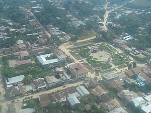
Contamana

This article needs additional citations for verification. (December 2014) |
Contamana | |
|---|---|
 View of the town | |
| Coordinates: 7°21′02″S 75°00′33″W / 7.350528°S 75.009189°W | |
| Country | Peru |
| Region | Loreto |
| Province | Ucayali |
| Elevation | 134 m (440 ft) |
| Population (2007)[2] | 15,036 |
| Time zone | UTC-5 (PET) |
| Climate | Af |
| Website | www.muniucayali.gob.pe |
Contamana is a town in the Loreto Region in northeastern Peru. It is the capital of both Ucayali Province and Contamana District and has an urban population of about 15,036 (as of 2007[2]). It has one airport.
Climate
[edit]| Climate data for Contamana, elevation 157 m (515 ft), (1991–2020) | |||||||||||||
|---|---|---|---|---|---|---|---|---|---|---|---|---|---|
| Month | Jan | Feb | Mar | Apr | May | Jun | Jul | Aug | Sep | Oct | Nov | Dec | Year |
| Mean daily maximum °C (°F) | 32.5 (90.5) | 31.9 (89.4) | 31.3 (88.3) | 31.3 (88.3) | 30.8 (87.4) | 30.4 (86.7) | 30.8 (87.4) | 32.3 (90.1) | 32.9 (91.2) | 33.1 (91.6) | 33.0 (91.4) | 32.8 (91.0) | 31.9 (89.4) |
| Mean daily minimum °C (°F) | 20.2 (68.4) | 20.0 (68.0) | 20.0 (68.0) | 19.7 (67.5) | 19.3 (66.7) | 19.0 (66.2) | 18.6 (65.5) | 19.0 (66.2) | 19.6 (67.3) | 20.1 (68.2) | 20.3 (68.5) | 20.4 (68.7) | 19.7 (67.4) |
| Average precipitation mm (inches) | 147.2 (5.80) | 173.3 (6.82) | 207.7 (8.18) | 177.8 (7.00) | 147.7 (5.81) | 79.8 (3.14) | 69.9 (2.75) | 73.2 (2.88) | 109.5 (4.31) | 145.2 (5.72) | 158.1 (6.22) | 126.9 (5.00) | 1,616.3 (63.63) |
| Source: National Meteorology and Hydrology Service of Peru[3] | |||||||||||||
References
[edit]- ^ "Official Contamana Infopage". Archived from the original on 2015-08-28. Retrieved 2015-11-08.
- ^ a b "Censo Nacional de Población y Vivienda 2007". Retrieved 2015-11-08.[permanent dead link]
- ^ "Normales Climáticas Estándares y Medias 1991-2020". National Meteorology and Hydrology Service of Peru. Archived from the original on 21 August 2023. Retrieved 17 June 2024.
External links
[edit]- Portal Oficial de Contamana - Municipalidad Provincial de Ucayali - Ucayali Province Council official website
- Fotos de Contamana
