Juvigny Val d'Andaine

Juvigny Val d'Andaine | |
|---|---|
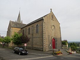
 The church in Juvigny-sous-Andaine | |
| Coordinates: 48°33′07″N 0°30′29″W / 48.552°N 0.508°W | |
| Country | France |
| Region | Normandy |
| Department | Orne |
| Arrondissement | Alençon |
| Canton | Bagnoles de l'Orne Normandie |
| Government | |
| • Mayor (2022–2026) | Henri Leroux[1] |
| Area 1 | 79.62 km2 (30.74 sq mi) |
| Population (2021)[2] | 2,114 |
| • Density | 27/km2 (69/sq mi) |
| Time zone | UTC+01:00 (CET) |
| • Summer (DST) | UTC+02:00 (CEST) |
| INSEE/Postal code | 61211 /61140, 61330 |
| 1 French Land Register data, which excludes lakes, ponds, glaciers > 1 km2 (0.386 sq mi or 247 acres) and river estuaries. | |
Juvigny Val d'Andaine (French pronunciation: [ʒyviɲi val dɑ̃dɛn]) is a commune in the department of Orne, northwestern France. The municipality was established on 1 January 2016 by merger of the former communes of La Baroche-sous-Lucé, Beaulandais, Juvigny-sous-Andaine (the seat), Loré, Lucé, Saint-Denis-de-Villenette and Sept-Forges.[3]
Geography
[edit]The commune is made up of the following collection of villages and hamlets, Lucé, Le Bois Jousselin, Le Jardin, La Baroche-sous-Lucé, Beaulandais, Saint-Denis-de-Villenette, La Vallée and Juvigny-Val-d'Andaine.[4]
It is 7,960 hectares (30.7 sq mi) in size. The highest point in the commune is 190 metres (620 ft).
The commune is within the Normandie-Maine Regional Natural Park.[5] Juvigny Val d'Andaine along with the communes of Perrou, Les Monts d'Andaine, Domfront en Poiraie, Dompierre and Champsecret shares part of the Bassin de l'Andainette a Natura 2000 conservation site.[6] The site measures 617 hectares and is home to creatures such as the Bullhead, Brook lamprey and white-clawed crayfish.[7]
The commune has the river Mayenne traversing its borders.
Population
[edit]| Year | Pop. | ±% p.a. |
|---|---|---|
| 1968 | 2,725 | — |
| 1975 | 2,568 | −0.84% |
| 1982 | 2,422 | −0.83% |
| 1990 | 2,411 | −0.06% |
| 1999 | 2,300 | −0.52% |
| 2007 | 2,280 | −0.11% |
| 2012 | 2,221 | −0.52% |
| 2017 | 2,193 | −0.25% |
| Source: INSEE[8] | ||
Points of interest
[edit]National heritage sites
[edit]The Commune has five buildings and areas listed as a Monument historique.[9]
- Bonvouloir castle remains of a fifteenth century castle and estate that was registered as a monument in 1995.[10]
- Etrigé Chapel a twelfth century chapel, registered as a Monument historique in 1997.[11]
- Mebzon Manor a fourteenth century Manor house, registered as a Monument historique in 1998.[12]
- Saint-Aignan Church a sixteenth century church, registered as a Monument historique in 1928.[13]
- Cross of the old cemetery a sixteenth century cross in Beaulandais, registered as a Monument historique in 1938.[14]
See also
[edit]References
[edit]- ^ "Répertoire national des élus: les maires" (in French). data.gouv.fr, Plateforme ouverte des données publiques françaises. 13 September 2022.
- ^ "Populations légales 2021" (in French). The National Institute of Statistics and Economic Studies. 28 December 2023.
- ^ Arrêté préfectoral 28 December 2015 (in French)
- ^ a b "Juvigny-Val-d'Andaine · France". Juvigny-Val-d'Andaine · France.
- ^ "rapport de charte" (PDF), parc-naturel-normandie-maine.fr/
- ^ "INPN - FSD Natura 2000 - FR2500119 - Bassin de l'Andainette - Description".
- ^ "Bassin de l'Andainette" (PDF). Ministère de la Transition écologique.
- ^ Population en historique depuis 1968, INSEE
- ^ "Les Monuments Historiques en Orne - 61". monumentum.fr.
- ^ "Ancien château de Bonvouloir à Juvigny Val d'Andaine - PA00110830". monumentum.fr.
- ^ "Chapelle d'Etrigé à Juvigny Val d'Andaine - PA61000010". monumentum.fr.
- ^ "Manoir de Mebzon à Juvigny Val d'Andaine - PA61000016". monumentum.fr.
- ^ "Eglise Saint-Aignan à Juvigny Val d'Andaine - PA00110950". monumentum.fr.
- ^ "Croix de l'ancien cimetière à Juvigny Val d'Andaine - PA00110738". monumentum.fr.


