Kozyatağı

Kozyatağı | |
|---|---|
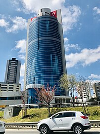
 Nidakule is one of the highest office buildings in Kozyatağı, Istanbul | |
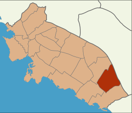
 Location of Kozyatağı in Kadıköy | |
| Coordinates: 40°58′08″N 29°05′11″E / 40.969°N 29.0865°E | |
| Country | Turkey |
| Province | Istanbul |
| District | Kadıköy |
| Population (2022) | 37,743 |
| Time zone | UTC+3 (TRT) |
Kozyatağı is a neighbourhood in the municipality and district of Kadıköy, Istanbul Province, Turkey.[1] Its population is 37,743 (2022).[2] It is to the East of Göztepe, northwest of Bostancı, south of Ataşehir and north of the coastal neighbourhoods.
Transport
[edit]The M4 and the planned M8 metro lines run through Kozyatağı, along with many bus lines and minibuses. It is also easily accessible by the D-100 highway. Kozyatağı is landlocked, but ferries in Kadıköy and Bostancı can be reached easily.
Surroundings
[edit]The area consists of mainly residential apartments along with many commercial towers and plazas. High-rise buildings are not common in the Anatolian side except Kozyatağı, Ataşehir and a few more areas. There are also many parks and green areas along with a shopping mall.
References
[edit]- ^ Mahalle, Turkey Civil Administration Departments Inventory. Retrieved 12 July 2023.
- ^ "Address-based population registration system (ADNKS) results dated 31 December 2022, Favorite Reports" (XLS). TÜİK. Retrieved 12 July 2023.

