Leirvatnet (Sørfold)

| Leirvatnet | |
|---|---|
 Leirvatnet Lake | |
 Interactive map of the lake | |
| Location | Sørfold in Nordland and Jokkmokk in Norrbotten |
| Coordinates | 67°17′28″N 16°14′51″E / 67.2910°N 16.2476°E |
| Basin countries | Norway and Sweden |
| Max. length | 3 kilometres (1.9 mi) |
| Max. width | 1 kilometre (0.62 mi) |
| Surface area | 2.57 km2 (0.99 sq mi) (2.51 km² in Norway) |
| Shore length1 | 7.72 kilometres (4.80 mi) |
| Surface elevation | 826 metres (2,710 ft) |
| References | NVE[1] |
| 1 Shore length is not a well-defined measure. | |
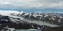
Leirvatnet[2] is a lake located on the border between Norway and Sweden. The majority of the 2.57-square-kilometre (0.99 sq mi) lake lies in Sørfold Municipality in Nordland county, Norway, and the remaining 0.06 square kilometres (15 acres) of the lake are located in Jokkmokk Municipality in Norrbotten County, Sweden. The lake lies at one end of the large Blåmannsisen glacier.[3]
See also
[edit]References
[edit]- ^ "Innsjødatabase". NVE.no (in Norwegian). Retrieved 2024-09-07.
- ^ "Informasjon om stadnamn". Norgeskart (in Norwegian). Kartverket. Retrieved 2024-09-07.
- ^ "Leirvatnet" (in Norwegian). yr.no. Retrieved 2012-04-10.