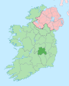
Maryborough East

Maryborough East Port Laoise Thoir (Irish) | |
|---|---|
 Dunamase, in the eastern part of Maryborough East | |
 Barony map of Queen's County, 1900; Maryborough East is blue, in the centre. | |
| Sovereign state | Ireland |
| Province | Leinster |
| County | Laois |
| Area | |
| • Total | 101.82 km2 (39.31 sq mi) |
Maryborough East or East Maryborough[1] (Irish: Port Laoise Thoir[2]) is a barony in County Laois (formerly called Queen's County or County Leix), Ireland.[3][4][5]
Etymology[edit]
Maryborough is the former name of the town of Portlaoise, established in 1548 and named after Queen Mary I; it was given its current name in 1929.[citation needed]
Geography[edit]
Maryborough East is located in central County Laois.
History[edit]
Maryborough East and West were in the Middle Ages the land of the Cinel Crimthann, an Irish clan with the surname Ó Duibh (Duffy or O'Diff).[6]
It is referred to in the topographical poem Tuilleadh feasa ar Éirinn óigh (Giolla na Naomh Ó hUidhrín, d. 1420):
Fa Dún Mascc as mín fuinn,
O'Duib for Chenel cCrioṁṫainn,
Triath an tíre fa ṫoraḋ,
Iath as míne measrogaḋ.
("Under Dun Masc of smooth land, O'Duibh is over Cinel-Criomthainn, Lord of the territory which is under fruit, Land of smoothest mast-fruit.")
Maryborough was originally a single barony; it was divided into East and West before 1807.
List of settlements[edit]
Below is a list of settlements in Maryborough East barony:
References[edit]
- ^ Gorton, John (9 July 2018). "A Topographical Dictionary of Great Britain and Ireland: Compiled from Local Information, and the Most Recent and Official Authorities". Chapman and Hall – via Google Books.
- ^ "Port Laoise Thoir/Maryborough East". Logainm.ie.
- ^ Lives of the Irish Saints: With Special Festivals, and the Commemorations of Holy Persons. Duffy – via Internet Archive.
Maryborough East.
- ^ "The Parliamentary Gazetteer of Ireland: Adapted to the New Poor-law, Franchise, Municipal and Ecclesiastical Arrangements, and Compiled with a Special Reference to the Lines of Railroad and Canal Communication as Existing in 1843-44; Illustrated by a Series of Maps, and Other Plates; and Presenting the Results, in Detail, of the Census of 1841, Compared with that of 1831". A. Fullarton. 9 July 2018 – via Google Books.
- ^ "The Parliamentary Gazetteer of Ireland: Adapted to the New Poor-law, Franchise, Municipal and Ecclesiastical Arrangements, and Compiled with a Special Reference to the Lines of Railroad and Canal Communication as Existing in 1843-44; Illustrated by a Series of Maps, and Other Plates; and Presenting the Results, in Detail, of the Census of 1841, Compared with that of 1831". A. Fullarton. 9 July 2018 – via Google Books.
- ^ "Sloinne". www.sloinne.ie.
