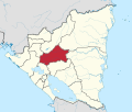
Muy Muy

Muy Muy | |
|---|---|
Municipality | |
| Coordinates: 12°46′N 85°38′W / 12.767°N 85.633°W | |
| Country | |
| Department | Matagalpa |
| Area | |
| • Municipality | 145 sq mi (375 km2) |
| Population (2005) | |
| • Municipality | 14,721 |
| • Density | 100/sq mi (39/km2) |
| • Urban | 4,037 |
| Climate | Aw |
Muy Muy is a municipality in the Matagalpa department of Nicaragua.
The municipality of Muy Muy was named by the Matagalpa people, who were the indigenous group native to the area. In their native language "muimui" translates to "the best" (sp. los mejores).[1] Translated to Spanish it's "very very", and in nawat it translates to "otter", which were once found in abundance in the region.
Climate
[edit]| Climate data for Muy Muy (1971–1990) | |||||||||||||
|---|---|---|---|---|---|---|---|---|---|---|---|---|---|
| Month | Jan | Feb | Mar | Apr | May | Jun | Jul | Aug | Sep | Oct | Nov | Dec | Year |
| Mean daily maximum °C (°F) | 27.3 (81.1) | 28.7 (83.7) | 30.8 (87.4) | 32.0 (89.6) | 32.0 (89.6) | 29.3 (84.7) | 28.1 (82.6) | 28.7 (83.7) | 29.4 (84.9) | 29.1 (84.4) | 28.4 (83.1) | 27.4 (81.3) | 29.3 (84.7) |
| Daily mean °C (°F) | 22.1 (71.8) | 22.8 (73.0) | 24.1 (75.4) | 25.1 (77.2) | 25.6 (78.1) | 24.2 (75.6) | 23.4 (74.1) | 23.7 (74.7) | 24.0 (75.2) | 23.8 (74.8) | 23.3 (73.9) | 22.3 (72.1) | 23.7 (74.7) |
| Mean daily minimum °C (°F) | 19.9 (67.8) | 19.1 (66.4) | 19.8 (67.6) | 20.8 (69.4) | 22.0 (71.6) | 21.7 (71.1) | 21.3 (70.3) | 21.2 (70.2) | 21.1 (70.0) | 20.9 (69.6) | 20.5 (68.9) | 19.6 (67.3) | 20.7 (69.3) |
| Average precipitation mm (inches) | 49 (1.9) | 23 (0.9) | 15 (0.6) | 28 (1.1) | 126 (5.0) | 142 (5.6) | 256 (10.1) | 257 (10.1) | — | 192 (7.6) | 97 (3.8) | 62 (2.4) | — |
| Average precipitation days (≥ 1 mm) | 9 | 5 | 3 | 3 | 10 | 10 | 22 | 20 | 20 | 18 | 12 | 12 | 144 |
| Mean monthly sunshine hours | 196.6 | 200.1 | 242.6 | 220.8 | 199.5 | 134.1 | 133.5 | 160.6 | 164.1 | 191.7 | 189.0 | 185.9 | 2,218.5 |
| Source: National Oceanic and Atmospheric Administration[2] | |||||||||||||
References
[edit]- ^ "Historia de Muy Muy". 8 April 2018.
- ^ "Station Name: MUY MUY" (TXT). National Oceanic and Atmospheric Administration. Retrieved 9 September 2024.
12°46′N 85°38′W / 12.767°N 85.633°W

