Narasannapeta

Narasannapeta | |
|---|---|
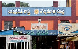
 APSRTC Bus Complex at Narasannapeta | |
| Coordinates: 18°25′00″N 84°03′00″E / 18.4167°N 84.0500°E | |
| Country | India |
| State | Andhra Pradesh |
| District | Srikakulam |
| Government | |
| • MLA | Dharmana Krishna Das |
| Area | |
| • Total | 5.18 km2 (2.00 sq mi) |
| Population (2011) | |
| • Total | 26,280 |
| • Density | 5,100/km2 (13,000/sq mi) |
| Languages | |
| • Official | Telugu |
| Time zone | UTC+5:30 (IST) |
| PIN | 532421 |
| Vehicle Registration | AP30 (Former) AP39 (from 30 January 2019)[2] |
| Lok Sabha constituency | Srikakulam |
| Vidhan Sabha constituency | Narasannapeta |
Narasannapeta is a census town in Srikakulam district of the Indian state of Andhra Pradesh. It is the mandal headquarters of Narasannapeta mandal in Srikakulam revenue division.[1][3] 43 villages are there under the administrative division of Narasannapeta.
Geography
[edit]Narsannapeta is located at 18°25′00″N 84°03′00″E / 18.4167°N 84.0500°E.[4] It has an average elevation of 18 m (59 ft). It is located 23 km from district capital Srikakulam.
Demographics
[edit]Narasannapeta is a Town in district of Srikakulam, Andhra Pradesh. The Narasannapeta Census Town has population of 26,280 of which 12,890 are males while 13,390 are females as per report released by Census India 2011.
Population of Children with age of 0-6 is 2663 which is 10.13% of total population of Narasannapeta (CT). In Narasannapeta Census Town, Female Sex Ratio is of 1039 against state average of 993. Moreover, Child Sex Ratio in Narasannapeta is around 937 compared to Andhra Pradesh state average of 939. Literacy rate of Narasannapeta city is 79.05% higher than state average of 67.02%. In Narasannapeta, Male literacy is around 85.86% while female literacy rate is 72.57%.
Narasannapeta Census Town has total administration over 6,530 houses to which it supplies basic amenities like water and sewerage. It is also authorized to build roads within Census Town limits and impose taxes on properties coming under its jurisdiction.
Legislative Assembly
[edit]Narasannapeta is an assembly constituency in Andhra Pradesh. There are 1,29,078 registered voters in Narasannapeta constituency in 1999 elections.
Politics
[edit]| Year | Winner Candidate | Party | Votes | Runner Candidate | Party | Votes | Margin(Majority) |
| 2019 | Dharmana krishna Das | Ysrcp | Dharamana KrishnaDas | YSRCP | 76559 | 4800 |
members:[5]
- 1951 - H. Satyanarayana Dora
- 1967 - S. Jagannadham
- 1973 - Baggu Sarojinamma
- 1978 - Dola Seeta Ramulu
- 1983 and 1985 - Simma Prabhakara Rao
- 1989 and 1999 - Dharmana Prasada Rao
- 1994 - Baggu Lakshmana Rao
- 2004 - Dharmana Krishna Das
- 2009 - Dharmana Krishna Das
- 2012 - Dharmana Krishna Das (bye poll)
- 2014- Baaggu Ramanamurthy.
Transportation
[edit]National Highway 16 (India) and National Highway 326A (India) Connects Narasannapeta town.
National Highway 326A (India) connects Narasannapeta town with Tilaru, Challavanipeta, Pathapatnam, Paralakhemundi, Mohana in Odisha.
APSRTC BUS CONNECTIVITY :-
Andhra Pradesh State Road Transport Corporation runs Number of busses through this Narasannapeta Bus stand.
It is a major Junction town, where APSRTC Runs buses to Mukhalingam, Pathapatnam, Paralakhemundi, Srikakulam, Kotabommali, Tekkali, Palasa, Pinnintipeta, Amadalavalasa, Polaki, Visakhapatnam, Rajahmundry, Vijayawada, Bhadrachalam, Eluru, Kakinada, Ravulapalem, Razole, Kaikaluru, Machilipatnam.
Nearest Railway Station are Srikakulam Road railway station (CHE), Tilaru railway station (TIU), Urlam railway station (ULM).
Education
[edit]The primary and secondary school education is imparted by government, aided and private schools, under the School Education Department of the state.[6][7] The medium of instruction followed by different schools are English, Telugu.
References
[edit]- ^ a b "District Census Handbook - Srikakulam" (PDF). Census of India. pp. 26–28, 54. Retrieved 11 January 2016.
- ^ "New 'AP 39' code to register vehicles in Andhra Pradesh launched". The New Indian Express. Vijayawada. 31 January 2019. Archived from the original on 3 February 2019. Retrieved 9 June 2019.
- ^ "Srikakulam district mandals" (PDF). Census of India. The Registrar General & Census Commissioner, India. pp. 199, 218. Retrieved 18 May 2015.
- ^ Falling Rain Genomics. Narsannapeta
- ^ Election Commission of India.A.P.Assembly results.1978-2004
- ^ "School Education Department" (PDF). School Education Department, Government of Andhra Pradesh. Archived from the original (PDF) on 7 November 2016. Retrieved 7 November 2016.
- ^ "The Department of School Education – Official AP State Government Portal | AP State Portal". www.ap.gov.in. Archived from the original on 7 November 2016. Retrieved 7 November 2016.
