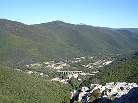
Puilaurens

You can help expand this article with text translated from the corresponding article in French. (December 2008) Click [show] for important translation instructions.
|
Puilaurens | |
|---|---|
 A general view of Puilaurens | |
| Coordinates: 42°48′38″N 2°18′21″E / 42.8106°N 2.3058°E | |
| Country | France |
| Region | Occitania |
| Department | Aude |
| Arrondissement | Limoux |
| Canton | La Haute-Vallée de l'Aude |
| Intercommunality | Pyrénées Audoises |
| Government | |
| • Mayor (2020–2026) | Jacques Galy[1] |
| Area 1 | 33.38 km2 (12.89 sq mi) |
| Population (2021)[2] | 268 |
| • Density | 8.0/km2 (21/sq mi) |
| Time zone | UTC+01:00 (CET) |
| • Summer (DST) | UTC+02:00 (CEST) |
| INSEE/Postal code | 11302 /11140 |
| Elevation | 399–1,420 m (1,309–4,659 ft) (avg. 424 m or 1,391 ft) |
| 1 French Land Register data, which excludes lakes, ponds, glaciers > 1 km2 (0.386 sq mi or 247 acres) and river estuaries. | |
Puilaurens (French pronunciation: [pɥiloʁɑ̃s] , also non-officially: Lapradelle-Puilaurens; Occitan: La Pradèla de Puèglhaurenç) is a commune in the Aude department in southern France.
It includes the hamlets of Lapradelle, Puilaurens and Lavignac. It is known for the medieval Puilaurens Castle.
Geography
[edit]The commune is situated on the Boulzane river and the Green Meridian.
History
[edit]The built-up area of Lapradelle did not exist until the 19th century and owes its development to activities related to water power taken from the Boulzane: textile spinning and sawmills.
In 1904, a railway was constructed from Quillan to Rivesaltes (the Carcassonne - Rivesaltes Line) passing through Lapradelle on a viaduct spanning the valley of the Boulzane. The line carried passengers until 1939. Afterwards it was used to transport feldspar between the Aude and the Pyrénées-Orientales, the railway line is today used in the summer for a tourist train, running between Axat and Rivesaltes.
In 1868, Puilaurens lost the hamlets of Salvezines and Le Caunil, established as the separate commune of Salvezines.
Population
[edit]Its inhabitants are called Puilaurenois.
| Year | Pop. | ±% |
|---|---|---|
| 1962 | 324 | — |
| 1968 | 378 | +16.7% |
| 1975 | 257 | −32.0% |
| 1982 | 222 | −13.6% |
| 1990 | 219 | −1.4% |
| 1999 | 236 | +7.8% |
| 2006 | 252 | +6.8% |
| 2007 | 254 | +0.8% |
| 2012 | 265 | +4.3% |
| 2015 | 266 | +0.4% |
See also
[edit]References
[edit]- ^ "Répertoire national des élus: les maires". data.gouv.fr, Plateforme ouverte des données publiques françaises (in French). 2 December 2020.
- ^ "Populations légales 2021" (in French). The National Institute of Statistics and Economic Studies. 28 December 2023.


