Ramberg (Harz)

| Ramberg | |
|---|---|
 Ramberg | |
| Highest point | |
| Elevation | 582 m (1,909 ft) |
| Coordinates | 51°41′09″N 11°04′57″E / 51.68583°N 11.0825°E |
| Geography | |
| Location | Saxony-Anhalt, Germany |
| Parent range | Harz Mountains |
| Geology | |
| Mountain type | Granite |
The Ramberg, also called the Ramberg Massif, is a granite massif, about 30 square kilometres in area, in the eastern part of the Harz Mountains of central Germany. It is located in the federal state of Saxony-Anhalt and lies southwest of Quedlinburg, between Friedrichsbrunn, Gernrode, Harzgerode and Thale. The Ramberg massif has a number of summits, the highest of which is the Viktorshöhe at 582 m above sea level (NN).
Places of interest[edit]
In the vicinity of the Viktorshöhe are the two natural monuments, the Kleine Teufelsmühle and Große Teufelsmühle, two granite tors that are shrouded in legend. Also within the Ramberg are the Bremer Teich, the Bear Monument and the castles ruins of Erichsberg.
-
 The Große Teufelsmühle tor
 -
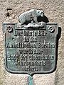 The Bear Monument

