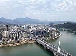
Shunchang County

Shunchang County 顺昌县 | |
|---|---|
 | |
 Location of Shunchang County within Nanping City | |
| Coordinates: 26°47′35″N 117°48′36″E / 26.793°N 117.810°E | |
| Country | People's Republic of China |
| Province | Fujian |
| Prefecture-level city | Nanping |
| Government | |
| • CPC County Committee Secretary | Jiang Jianhua |
| Area | |
| • Land | 1,985 km2 (766 sq mi) |
| Population (2020 census) | |
| • County | 179,064 |
| • Urban | 92,001 |
| • Rural | 87,063 |
| Time zone | UTC+8 (China Standard) |
| Vehicle licence plates | 闽H |
| Website | www.fjsc.gov.cn |
Shunchang County (simplified Chinese: 顺昌县; traditional Chinese: 順昌縣; pinyin: Shùnchāng Xiàn; Northern Min: Sē̤ng-chióng-gṳ̄ing) is a county under the administration of Nanping City, in the northwest of Fujian province, People's Republic of China. The county's name was established in 933, during the Tang dynasty. It has a total population of approximately 179,064 people as of the end of 2020.[1] It is a key region for forestry and the production of coarse bamboo in Fujian.
Administrative divisions
[edit]Shunchang County administers one subdistrict, seven towns, and four rural townships. The subdistrict is Shuangxi. The towns include Jianxi, Yangkou, Yuankeng, Bushang, Dali, Dagan, and Renshou. The rural townships include Yangdun, Zhengfang, Lanxia, and Gaoyang.
Geography
[edit]Shunchang County has two major brooks, Futunxi and Jinxi, as well as numerous smaller tributaries.
Specialty
[edit]- Renshou Guandan (仁寿灌蛋)
Notable people
[edit]Climate
[edit]| Climate data for Shunchang (1991–2020 normals, extremes 1981–2010) | |||||||||||||
|---|---|---|---|---|---|---|---|---|---|---|---|---|---|
| Month | Jan | Feb | Mar | Apr | May | Jun | Jul | Aug | Sep | Oct | Nov | Dec | Year |
| Record high °C (°F) | 28.1 (82.6) | 33.2 (91.8) | 33.8 (92.8) | 35.9 (96.6) | 36.7 (98.1) | 37.5 (99.5) | 40.8 (105.4) | 40.3 (104.5) | 38.2 (100.8) | 36.2 (97.2) | 34.4 (93.9) | 28.5 (83.3) | 40.8 (105.4) |
| Mean daily maximum °C (°F) | 14.0 (57.2) | 16.3 (61.3) | 19.3 (66.7) | 24.8 (76.6) | 28.4 (83.1) | 31.0 (87.8) | 34.4 (93.9) | 34.0 (93.2) | 31.2 (88.2) | 26.9 (80.4) | 21.5 (70.7) | 16.0 (60.8) | 24.8 (76.7) |
| Daily mean °C (°F) | 8.9 (48.0) | 11.0 (51.8) | 14.0 (57.2) | 19.1 (66.4) | 22.9 (73.2) | 25.8 (78.4) | 28.3 (82.9) | 27.8 (82.0) | 25.4 (77.7) | 20.6 (69.1) | 15.5 (59.9) | 10.3 (50.5) | 19.1 (66.4) |
| Mean daily minimum °C (°F) | 5.7 (42.3) | 7.6 (45.7) | 10.7 (51.3) | 15.4 (59.7) | 19.4 (66.9) | 22.4 (72.3) | 24.0 (75.2) | 24.0 (75.2) | 21.7 (71.1) | 16.8 (62.2) | 12.0 (53.6) | 6.8 (44.2) | 15.5 (60.0) |
| Record low °C (°F) | −4.5 (23.9) | −3.2 (26.2) | −3.2 (26.2) | 4.3 (39.7) | 10.2 (50.4) | 14.0 (57.2) | 19.5 (67.1) | 18.8 (65.8) | 13.0 (55.4) | 4.9 (40.8) | −0.8 (30.6) | −7.7 (18.1) | −7.7 (18.1) |
| Average precipitation mm (inches) | 71.7 (2.82) | 107.5 (4.23) | 211.5 (8.33) | 196.6 (7.74) | 260.5 (10.26) | 337.8 (13.30) | 149.6 (5.89) | 153.3 (6.04) | 91.5 (3.60) | 58.7 (2.31) | 70.8 (2.79) | 60.6 (2.39) | 1,770.1 (69.7) |
| Average precipitation days (≥ 0.1 mm) | 11.5 | 13.6 | 18.4 | 17.0 | 18.4 | 18.8 | 12.6 | 14.2 | 10.4 | 7.2 | 8.3 | 9.1 | 159.5 |
| Average snowy days | 0.5 | 0.5 | 0 | 0 | 0 | 0 | 0 | 0 | 0 | 0 | 0 | 0.3 | 1.3 |
| Average relative humidity (%) | 81 | 81 | 82 | 80 | 81 | 83 | 77 | 78 | 78 | 77 | 80 | 80 | 80 |
| Mean monthly sunshine hours | 86.2 | 85.3 | 90.1 | 110.6 | 130.9 | 136.5 | 234.0 | 215.0 | 175.2 | 159.9 | 120.0 | 109.3 | 1,653 |
| Percent possible sunshine | 26 | 27 | 24 | 29 | 31 | 33 | 56 | 54 | 48 | 45 | 37 | 34 | 37 |
| Source: China Meteorological Administration[2][3] | |||||||||||||
See also
[edit]References
[edit]- ^ "Shùnchāng Xiàn (County, China) - Population Statistics, Charts, Map and Location". www.citypopulation.de. Retrieved 2024-10-30.
- ^ 中国气象数据网 – WeatherBk Data (in Simplified Chinese). China Meteorological Administration. Retrieved 23 June 2023.
- ^ 中国气象数据网 (in Simplified Chinese). China Meteorological Administration. Retrieved 23 June 2023.
