Sobrarbe

You can help expand this article with text translated from the corresponding article in Aragonese. (April 2009) Click [show] for important translation instructions.
|
Sobrarbe | |
|---|---|
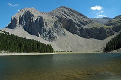
 Bassa de la Mora or Ibon de Plan near Cotiella. | |
 | |
| Country | |
| Autonomous community | Aragon |
| Province | Huesca |
| Capital | Aínsa, Boltaña |
| Municipalities | List
|
| Area | |
| • Total | 2,202.70 km2 (850.47 sq mi) |
| Population | |
| • Total | 7,293 |
| • Density | 3.3/km2 (8.6/sq mi) |
| Time zone | UTC+1 (CET) |
| • Summer (DST) | UTC+2 (CEST) |

Sobrarbe is one of the comarcas of Aragon, Spain. It is located in the northern part of the province of Huesca, part of the autonomous community of Aragon in Spain. Many of its people speak the Aragonese language locally known as fabla.
Sobrarbe is a mountainous region with some of the highest altitudes in the Pyrenees mountain range,[1][2] extending from the heights of the Axial Pyrenees in the north and in the border with France, to the external Pyrenean mountain ranges in the south which separate it from the Aragonese mountains.
The administrative capital is Boltaña and the economic development capital is Aínsa.
History
[edit]Sobrarbe was one of the Christian principalities of the Marca Hispanica, with obscure origins. Legend says there was a Kingdom of Sobrarbe, where a cross appeared upon a tree Latin: Supra Arbore.

It became part of the County of Aragon, but in the early 9th century was held for five years by Amrus ibn Yusuf, the governor of Zaragoza, being retaken after his death. Sobrarbe was joined to the County of Ribagorza in the early 10th century through the marriage of Bernard I of Ribagorza to Toda Galíndez of Aragon, daughter of Galindo Aznárez II. However, in the late 10th and early 11th century, a series of incursions from the south left it disorganized and depopulated, and for a time it again fell under Muslim control. This was reversed by Sancho the Great of Pamplona, who reconquered the region in 1015, similarly extending his power into Ribagorza over the subsequent years. Whatever hereditary claim might have existed was subsequently brought to Sancho through his wife Muniadona of Castile, heiress to the Ribagorza counts.
Sancho divided the territories he had united, and his third son, Gonzalo, was given the counties of Sobrarbe and Ribagorza. After the death of Gonzalo in 1038, his illegitimate half-brother Ramiro I of Aragon brought Sobrarbe and Ribagorza into his hands, creating the nucleus of the Kingdom of Aragon.
Sobrarbe Geopark
[edit]The entire territory of Sobrarbe is "Sobrarbe Geopark" which is a member of the European Geoparks Network (2004-) and Global Geoparks Network (2006-) on account of its outstanding geological heritage, educational programs and projects, and promotion of geotourism.[3]
Municipalities
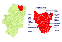
[edit]Abizanda, Aínsa-Sobrarbe, Bárcabo, Bielsa, Boltaña, Broto, Fanlo, Fiscal, La Fueva, Gistaín, Labuerda, Laspuña, Palo, Plan, Puértolas, El Pueyo de Araguás, San Juan de Plan, Tella-Sin, Torla
See also
[edit]References
[edit]- ^ (in Spanish) ANTOR CASTELLARNAU, Ramón et alter. Sobrarbe (num. 21 en a colección Red Natural de Aragón); Ed. Gobierno de Aragón + Sodemasa + PRAMES. Zaragoza, 2008. ISBN 978-84-8321-821-1
- ^ (in Spanish) PALLARUELO CAMPO, Severino et al. Comarca de Sobrarbe (Num. 23 en a «Colección Territorio»). Gobierno de Aragón; Zaragoza, 2007. ISBN 84-7753-630-9
- ^ Sobrarbe Geopark (Geoparque de Sobrarbe)
