Tindfjallajökull

| Tindfjallajökull | |
|---|---|
 Tindfjallajökull | |
| Highest point | |
| Elevation | 1,462 m (4,797 ft)[1] |
| Prominence | 1,200 m (3,900 ft)[2]: 24 |
| Coordinates | 63°48′N 19°35′W / 63.8°N 19.58°W |
| Dimensions | |
| Area | 300 km2 (120 sq mi)[2]: 22 |
| Geography | |
| Location | Iceland |
| Parent range | Mid-Atlantic Ridge |
| Geology | |
| Mountain type | Stratovolcano |
| Last eruption | Possibly Holocene |
 Geological features near the Tindfjallajökull volcanic system (red outline). Other shading shows: calderas, central volcanoes and fissure swarms, subglacial terrain above 1,100 m (3,600 ft), and seismically active areas. Clicking on the image enlarges to full window and enables mouse-over with more detail. | |
Tindfjallajökull (Icelandic pronunciation: [ˈtʰɪntˌfjatlaˌjœːkʏtl̥] , alternatively Tindafjallajökull)[3] is a glacier in the south of Iceland whose name is also given to the underlying stratovolcano. Tindfjöll ([ˈtʰɪntˌfjœtl̥], "peak mountains") is a ridge that extends to the south of the glacier and is an alternative name for the volcano.[2]: 22 [4][5] The name of the glacier in Icelandic means "Tindfjöll glacier".
Geography[edit]
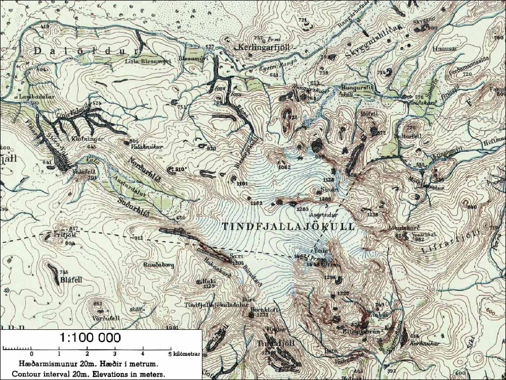
Its highest peak is Ýmir [ˈiːmɪr̥] at 1,462 m (4,797 ft),[1][6] which takes its name from the giant Ýmir of Norse mythology. The peak Ýma is about 500 m (1,600 ft) to its east.[1] The Thórólfsfell (Þórólfsfel) tuya at 595 m (1,952 ft) is on the southern flanks of Tindfjallajökull, about 8 km (5.0 mi) south of the glacier.[1][7] Its eastern slopes abutt the Þórsmörk ignimbrite.[2]: 29 The western flank has a prominence near Austurdalur and the eastern flank that of Vestriöxl at 1,002 m (3,287 ft).[2]: 24 [1] About 2 km (1.2 mi) to the north of Ýma is the peak of Sindri at 1,272 m (4,173 ft). Ásgrindur at 1,299 m (4,262 ft) is a similar distance north of Ýmir.
Volcano[edit]
The central volcano is 15 to 20 km (9.3 to 12.4 mi) in diameter with a 5 by 7 km (3.1 by 4.3 mi) wide caldera and has erupted rocks of basaltic to rhyolitic composition.[5] The most recent eruption is suspected to have been in the Holocene,[4] and the prior mountain building eruptions must have been before 55,000 years ago.[8] There are eight tuyas in the volcanic system.[2]: 26 The largest, the asymmetric Thórólfsfell tuya with its area of about 8 km2 (3.1 sq mi) and prominence of about 450 m (1,480 ft) is the type tuya for tuya's where there is no evidence for the presence of a large and long-lived meltwater lake under the ice cover, as meltwater was able to drain away between its formative eruptions.[7] In the 1980's it was postulated that the Þórsmörk ignimbrite originated from the volcano but it originated from Torfajökull to the north.[2]: 27 [8] Sultarfell is a pale coloured rhyolitic hill in the fissure swarm north-east of Tindfjallajökull.[2]: 27 There is a hot spring in Hitagil to the south-east so some geothermal activity remains.[2]: 24
Glacier[edit]
| Tindfjallajökull | |
|---|---|
| Type | Glacier |
| Location | Iceland |
| Coordinates | 63°48′N 19°35′W / 63.800°N 19.583°W |
| Area | 12.4 km2 (4.8 sq mi).[9] |
| Status | Retreating |
 Map of Tindfjallajökull glacier. (light grey shading with white outline). Clicking on the map to enlarge it enables mouse over that allows identification of other glacial catchments. | |
It is capped by a glacier that has been mapped to a maximum in the 1890's of about 22.6 km2 (8.7 sq mi) in area, but which by 2019 had had a 45% decrease in area. In 1945 to 1946 it was mapped to an area of 16.8 km2 (6.5 sq mi), in 2000 15 km2 (5.8 sq mi)[10] and 2019 12.4 km2 (4.8 sq mi).[9][10] The only current outlet glacier with a moraine is unnamed down the Eystri Botná valley but between 1994 and 2006[11] had surge glacier characteristics before regressing again. Part of the glacier to the north has now separated into three with one glacier being called Blesárjökull.[1] A small glacier on the eastern slopes of Ýma called Ýmujökull has disappeared.[1]
The rivers that flow from the glacier are Hvítmaga [ˈkʰvitˌmaːɣa] to the north-east, Gilsá [ˈcɪlsˌauː] to the south, Þórólfsá [ˈθouːroul(f)sˌauː] to the south-west, Valá [ˈvaːlˌauː] to the north-west and Blesá [ˈplɛːsˌauː] to the north. Hvítmaga, Gilsá and Þórólfsá drain into Markarfljót while Valá and Blesá drain into Eystri Rangá [ˈeistrɪ ˈrauŋkˌauː].
See also[edit]
References[edit]
- ^ a b c d e f g "National Land Survey of Iceland-Mapviewer (Kortasja-Landmælingar Íslands)". Retrieved 27 May 2024.
- ^ a b c d e f g h i Moles, J. D.; McGarvie, D.; Stevenson, J. A.; Sherlock, S. C. (2018). "Geology of Tindfjallajökull volcano, Iceland". Journal of Maps. 14 (2): 22–31. doi:10.1080/17445647.2018.1425163.
- ^ Sigurðsson, Oddur; Williams, Richard S. (2008). "Geographic Names of Iceland's Glaciers:Historic and Modern". In Richard S. Williams Jr.; Jane G. Ferrigno (eds.). Satellite Image Atlas of Glaciers of the World series (U.S. Geological Survey Professional Paper 1386-D (PDF). Retrieved 21 May 2024.
- ^ a b "Tindfjallajökull". Global Volcanism Program. Smithsonian Institution.
- ^ a b Guðmundsson, Magnús T. (2019). "Catalogue of Icelandic Volcanoes:Tindfjallajökull Alternative name: Tindfjöll". Retrieved 26 May 2024.: Short Description
- ^ "nat.is - Tindfjallajökull". Archived from the original on 2012-07-09. Retrieved 2007-09-12.
- ^ a b Hodgetts, A.G.; McGarvie, D.; Tuffen, H.; Simmons, I.C. (2021). "The Thórólfsfell tuya, South Iceland–A new type of basaltic glaciovolcano". Journal of Volcanology and Geothermal Research. 411: 107175. Bibcode:2021JVGR..41107175H. doi:10.1016/j.jvolgeores.2021.107175.
- ^ a b Moles, J.D.; McGarvie, D.; Stevenson, J.A.; Sherlock, S.C.; Abbott, P.M.; Jenner, F.E.; Halton, A.M. (2019). "Widespread tephra dispersal and ignimbrite emplacement from a subglacial volcano (Torfajökull, Iceland)". Geology. 47 (6): 577–580. doi:10.1130/G46004.1.
- ^ a b Hannesdóttir, H.; Sigurðsson, O.; Þrastarson, R.H.; Guðmundsson, S.; Belart, J.M.; Pálsson, F.; Magnusson, E.; Víkingsson, S.; Kaldal, I.; Jóhannesson, T. (2020). "A national glacier inventory and variations in glacier extent in Iceland from the Little Ice Age maximum to 2019". Jökull. 12: 1–34. doi:10.33799/jokull2020.70.001.: Table 2
- ^ a b Miodońska, Alicja. Assessing evolution of ice caps in Suðurland, Iceland, in years 1986 - 2014, using multispectral satellite imagery: Masters Thesis (Thesis). Lund, Sweden: Lund University. pp. 1–110.: 20
- ^ Arnar, Elías (2021). Geomorphological mapping of a paraglacial slope instability at the southeastern Tindfjallajökull glacier: BS thesis (Thesis). Reykjavík, Iceland: Faculty of Life and Environmental Sciences, University of Iceland. pp. 1–51.: 17–19, 27
External links[edit]
- Tindfjallajökull Archived 2019-03-01 at the Wayback Machine in the Catalogue of Icelandic Volcanoes
- Map of the area