Toshimaen Station

SI39 E36 Toshimaen Station 豊島園駅 | |||||||||||||||||||||
|---|---|---|---|---|---|---|---|---|---|---|---|---|---|---|---|---|---|---|---|---|---|
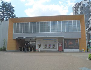
 The Seibu station in July 2023 | |||||||||||||||||||||
| General information | |||||||||||||||||||||
| Location | 4-16-5 Nerima, Nerima-ku, Tokyo Japan | ||||||||||||||||||||
| Operated by | |||||||||||||||||||||
| Line(s) | |||||||||||||||||||||
| Platforms | 2 island platforms (1 Seibu, 1 Toei) | ||||||||||||||||||||
| Tracks | 4 | ||||||||||||||||||||
| Construction | |||||||||||||||||||||
| Structure type | At grade (Seibu), Underground (Toei) | ||||||||||||||||||||
| Other information | |||||||||||||||||||||
| Station code | SI39 (Seibu) E36 (Toei) | ||||||||||||||||||||
| History | |||||||||||||||||||||
| Opened | 15 October 1927 | ||||||||||||||||||||
| Previous names | Toshima (until 1933) | ||||||||||||||||||||
| Passengers | |||||||||||||||||||||
| Seibu, FY2013 | 13,583 daily | ||||||||||||||||||||
| Services | |||||||||||||||||||||
| |||||||||||||||||||||
| |||||||||||||||||||||
Toshimaen Station (豊島園駅, Toshimaen-eki) is a railway station in Nerima, Tokyo, Japan, operated by the private railway operator Seibu Railway and the Tokyo subway operator Toei Subway. It is located next to the former site of Toshimaen amusement park and the current Warner Bros. Studio Tour Tokyo – The Making of Harry Potter.
Lines
[edit]Toshimaen Station is served by the Seibu Toshima Line and the Toei Ōedo Line.
Platforms
[edit]Seibu Toshima Line
[edit]The Seibu station consists of an island platform serving two terminating tracks.[1] An additional disembarking platform originally existed opposite platform 2.[1]
| 1/2 | for Nerima and Ikebukuro |
- Seibu platforms, 2023
Toei Ōedo Line
[edit]The Toei station has an island platform serving two tracks.[1]
| 1 | E Ōedo Line | for Tochōmae, Roppongi, and Daimon |
| 2 | E Ōedo Line | for Hikarigaoka |
- Toei platforms, 2023
History
[edit]The Seibu station opened on 15 October 1927, originally named Toshima Station (豊島駅).[2] It was renamed Toshimaen on 1 March 1933.[2] The Toei station opened on 10 December 1991.[2]
Station numbering was introduced on all Seibu Railway lines during fiscal 2012, with Toshimaen Station becoming "SI39".[3]
Passenger statistics
[edit]In fiscal 2013, the Seibu station was the 60th busiest on the Seibu network with an average of 13,583 passengers daily.[4]
The passenger figures for the Seibu station in previous years are as shown below.
| Fiscal year | Daily average |
|---|---|
| 2000 | 12,560[2] |
| 2009 | 12,927[5] |
| 2010 | 12,639[5] |
| 2011 | 12,707[6] |
| 2012 | 13,318[4] |
| 2013 | 13,583[4] |
Surrounding area
[edit]
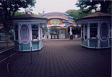
- Toshimaen amusement park (formerly)
- Warner Bros. Studio Tour Tokyo – The Making of Harry Potter
See also
[edit]References
[edit]- ^ a b c Kawashima, Ryozo (March 2011). 日本の鉄道 中部ライン 全線・全駅・全配線 第12巻 東京都心北部 [Railways of Japan - Chubu Line - Lines/Stations/Track plans - Vol 12 Northern Central Tokyo]. Japan: Kodansha. p. 31/66. ISBN 978-4-06-270072-6.
- ^ a b c d Terada, Hirokazu (July 2002). データブック日本の私鉄 [Databook: Japan's Private Railways]. Japan: Neko Publishing. pp. 202–215. ISBN 4-87366-874-3.
- ^ 西武線全駅で駅ナンバリングを導入します [Station numbering to be introduced at all Seibu stations] (PDF). News Release (in Japanese). Japan: Seibu Railway. 23 February 2012. Archived from the original (PDF) on 2015-09-24. Retrieved 10 February 2013.
- ^ a b c 駅別乗降人員 2013(平成25)年度 1日平均 [Average daily station usage figures (fiscal 2013)] (PDF) (in Japanese). Japan: Seibu Railway. Archived from the original (PDF) on 14 July 2014. Retrieved 2 September 2014.
- ^ a b 駅別乗降人員 2010(平成22)年度 1日平均 [Average daily station usage figures (fiscal 2010)] (PDF) (in Japanese). Japan: Seibu Railway. Archived from the original (PDF) on 26 June 2011. Retrieved 26 January 2013.
- ^ 駅別乗降人員 2011(平成23)年度 1日平均 [Average daily station usage figures (fiscal 2011)] (PDF) (in Japanese). Japan: Seibu Railway. Archived from the original (PDF) on 1 November 2012. Retrieved 2 September 2014.
External links
[edit]- Toshimaen Station information (Seibu Railway) (in Japanese)
- Toshimaen Station information (Toei) (in English)


