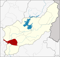
Tron district

Tron ตรอน | |
|---|---|
 District location in Uttaradit province | |
| Coordinates: 17°28′56″N 100°6′47″E / 17.48222°N 100.11306°E | |
| Country | Thailand |
| Province | Uttaradit |
| Seat | Wang Daeng |
| Area | |
| • Total | 314.501 km2 (121.430 sq mi) |
| Population (2008) | |
| • Total | 35,036 |
| • Density | 113.6/km2 (294/sq mi) |
| Time zone | UTC+7 (ICT) |
| Postal code | 53140 |
| Geocode | 5302 |
Tron (Thai: ตรอน, pronounced [trɔ̄ːn]) is a district (amphoe) of Uttaradit province, northern Thailand.
Geography
[edit]Neighboring districts are (from the north clockwise) Laplae, Mueang Uttaradit, Thong Saen Khan, Phichai, of Uttaradit Province, Si Nakhon and Si Satchanalai of Sukhothai province
Administration
[edit]The district is divided into five sub-districts (tambons), which are further subdivided into 47 villages (mubans). There are two sub-district municipalities (thesaban tambon): Tron covers parts of tambon Wang Daeng, and Ban Kaeng covers parts of the same-named tambon. There are a further five tambon administrative organizations (TAO).
| No. | Name | Thai | Villages | Pop.[1] |
|---|---|---|---|---|
| 1. | Wang Daeng | วังแดง | 12 | 11,091 |
| 2. | Ban Kaeng | บ้านแก่ง | 10 | 7,567 |
| 3. | Hat Song Khwae | หาดสองแคว | 7 | 4,148 |
| 4. | Nam Ang | น้ำอ่าง | 10 | 7,975 |
| 5. | Khoi Sung | ข่อยสูง | 8 | 4,255 |
References
[edit]- ^ "Population statistics 2008". Department of Provincial Administration. Archived from the original on 2009-08-20.
External links
[edit]- amphoe.com (Thai)