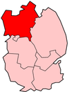
West Lindsey

| Niet-metropolitaans district in Engeland | |||
|---|---|---|---|
  | |||
| Situering | |||
| Land | Engeland | ||
| County | Lincolnshire | ||
| Regio | East Midlands | ||
| Coördinaten | 53°21'NB, 0°36'WL | ||
| Algemeen | |||
| Oppervlakte | 1155,7321[1] km² | ||
| Inwoners (2018[2]) | 94.869 (82 inw./km²) | ||
| ONS-code | E07000142 | ||
| Website | www | ||
| Detailkaart | |||
 | |||
| |||
West Lindsey is een Engels district in het shire-graafschap (non-metropolitan county OF county) Lincolnshire en telt 79.515 inwoners. De oppervlakte bedraagt 1156 km².
Van de bevolking is 18,2% ouder dan 65 jaar. De werkloosheid bedraagt 3,2% van de beroepsbevolking (cijfers volkstelling 2001).
Civil parishes in district West Lindsey
[bewerken | brontekst bewerken]Aisthorpe, Apley, Bardney, Barlings, Bigby, Bishop Norton, Blyborough, Blyton, Brampton, Brattleby, Broadholme, Brocklesby, Brookenby, Broxholme, Bullington, Burton, Buslingthorpe, Cabourne, Caenby, Caistor, Cammeringham, Cherry Willingham, Claxby, Cold Hanworth, Corringham, Dunholme, East Ferry, East Stockwith, Faldingworth, Fenton, Fillingham, Fiskerton, Friesthorpe, Fulnetby, Gainsborough, Gate Burton, Glentham, Glentworth, Goltho, Grange de Lings, Grasby, Grayingham, Great Limber, Greetwell, Hackthorn, Hardwick, Harpswell, Heapham, Hemswell, Hemswell Cliff, Holton cum Beckering, Holton le Moor, Ingham, Keelby, Kettlethorpe, Kexby, Kirmond le Mire, Knaith, Laughton, Lea, Legsby, Linwood, Lissington, Market Rasen, Marton, Middle Rasen, Morton, Nettleham, Nettleton, Newball, Newton on Trent, Normanby by Spital, Normanby le Wold, North Carlton, North Kelsey, North Willingham, Northorpe, Osgodby, Owersby, Owmby, Pilham, Rand, Reepham, Riby, Riseholme, Rothwell, Saxby, Saxilby with Ingleby, Scampton, Scothern, Scotter, Scotton, Searby cum Owmby, Sixhills, Snarford, Snelland, Snitterby, Somerby, South Carlton, South Kelsey, Spridlington, Springthorpe, Stainfield, Stainton by Langworth, Stainton le Vale, Stow, Sturton by Stow, Sudbrooke, Swallow, Swinhope, Tealby, Thonock, Thoresway, Thorganby, Thorpe in the Fallows, Toft Newton, Torksey, Upton, Waddingham, Walesby, Walkerith, Welton, West Firsby, West Rasen, Wickenby, Wildsworth, Willingham, Willoughton.
- ↑ Office for National Statistics → Download → SAM_for_Administrative_Areas_(2018).zip → SAM_LAD_DEC_2018_UK.xlsx.
- ↑ https://www.ons.gov.uk/file?uri=/peoplepopulationandcommunity/populationandmigration/populationestimates/datasets/populationestimatesforukenglandandwalesscotlandandnorthernireland/mid20182019laboundaries/ukmidyearestimates20182019ladcodes.xls Schatting Office for National Statistics: knop MYE5 → kolom Estimated Population mid-2018]