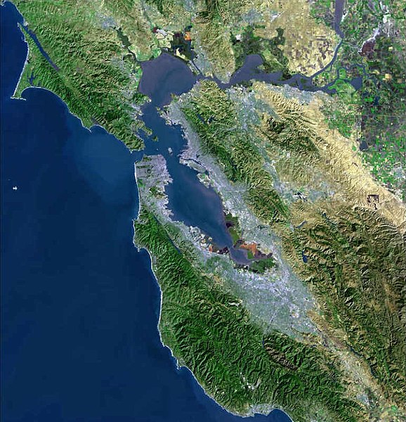
Файл:BayareaUSGS.jpg
 Из Википедии, бесплатной энциклопедии

Исходный файл (769 × 798 пкс, размер файла: 613 КБ, MIME-тип: image/jpeg)
История файла
Нажмите на дату/время, чтобы посмотреть файл, который был загружен в тот момент.
| Дата/время | Миниатюра | Размеры | Участник | Примечание | |
|---|---|---|---|---|---|
| текущий | 00:08, 19 апреля 2009 |  | 769 × 798 (613 КБ) | Yarnalgo | rmving little border on top and right and rmving USGS watermark |
| 15:14, 22 декабря 2006 |  | 770 × 800 (98 КБ) | Nk | Satellite map of the San Francisco Bay Area from the U.S. Geological Survey. The effect of the San Andreas Fault on the terrain can been seen on a diagonal line from the upper left corner to the lower right. The green and golden mountainous regions (wri |
Использование файла
Следующая страница использует этот файл:
Глобальное использование файла
Данный файл используется в следующих вики:
- Использование в ar.wikipedia.org
- سان فرانسيسكو
- سان خوسيه (كاليفورنيا)
- مقاطعة ألاميدا (كاليفورنيا)
- مقاطعة كونترا كوستا (كاليفورنيا)
- مقاطعة مارين (كاليفورنيا)
- مقاطعة نابا (كاليفورنيا)
- مقاطعة سان ماتيو (كاليفورنيا)
- مقاطعة سانتا كلارا (كاليفورنيا)
- مقاطعة سولانو (كاليفورنيا)
- مقاطعة سونوما (كاليفورنيا)
- ستانفورد (كاليفورنيا)
- فاليجو (كاليفورنيا)
- نابا (كاليفورنيا)
- أوكلاند (كاليفورنيا)
- فريمونت (كاليفورنيا)
- هايوارد (كاليفورنيا)
- سان ماتيو (كاليفورنيا)
- ريدوود (كاليفورنيا)
- سانيفال (كاليفورنيا)
- سانتا كلارا (كاليفورنيا)
- سانتا روسا (كاليفورنيا)
- بيتالوما
- فيرفيلد (كاليفورنيا)
- مارتينز (كاليفورنيا)
- بنيسيا (كاليفورنيا)
- ريتشموند (كاليفورنيا)
- سان رافاييل (كاليفورنيا)
- أنتيوك
- منطقة خليج سان فرانسيسكو
- خليج سان فرانسيسكو
- ألاميدا (كاليفورنيا)
- ألباني (كاليفورنيا)
- أميريكان كانيون (كاليفورنيا)
- بيلمونت (كاليفورنيا)
- بيركيلي (كاليفورنيا)
- برينتوود (كاليفورنيا)
- بورلينغامي (كاليفورنيا)
- كامببيل (كاليفورنيا)
- كلايتون (كاليفورنيا)
- كونكورد (كاليفورنيا)
- كوبيرتينو (كاليفورنيا)
- دالي سيتي (كاليفورنيا)
- دانفيل (كاليفورنيا)
- ديكسون (كاليفورنيا)
- دوبلين (كاليفورنيا)
- إيست بالو ألتو (كاليفورنيا)
- إل سيرريتو (كاليفورنيا)
- إميريفيلي (كاليفورنيا)
- فوستير سيتي (كاليفورنيا)
- غيلروي (كاليفورنيا)
Просмотреть глобальное использование этого файла.
