Файл:Harz map.png
 Из Википедии, бесплатной энциклопедии

Размер этого предпросмотра: 800 × 482 пкс. Другие разрешения: 320 × 193 пкс | 640 × 385 пкс | 1024 × 617 пкс | 1280 × 771 пкс | 2529 × 1523 пкс.
Исходный файл (2529 × 1523 пкс, размер файла: 3,15 МБ, MIME-тип: image/png)
Этот файл находится на Викискладе. Сведения о нём показаны ниже. Викисклад — централизованное хранилище для свободных файлов, используемых в проектах Викимедиа. |
Краткое описание
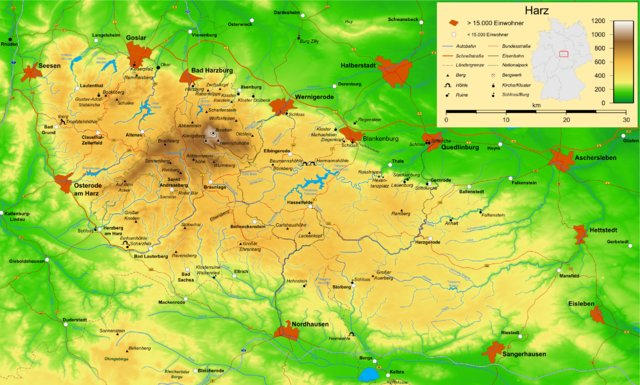
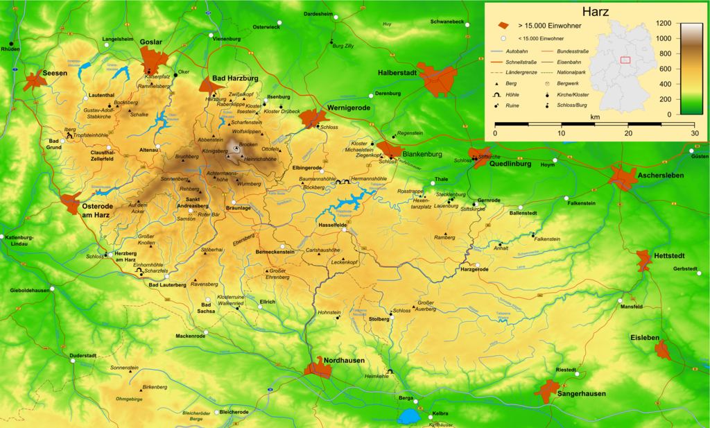
| Описание | Map of the Harz mountains in Germany with mountains, rivers, lakes, reservoirs, all highways, all Bundesstraßen, Harzquerbahn, Brockenbahn, Selketalbahn, major towns and sights. |
| Дата | |
| Источник | Собственная работа |
| Автор | Bamse |
| Другие версии | Производные работы от этого файла: Karte Harzer Schmalspurbahnen.png  , ,  , ,  |
The map has been created with the Generic Mapping Tools: https://www.generic-mapping-tools.org/ using one or more of these public-domain datasets for the relief:
|
 | Разрешается копировать, распространять и/или изменять этот документ в соответствии с условиями GNU Free Documentation License версии 1.2 или более поздней, опубликованной Фондом свободного программного обеспечения, без неизменяемых разделов, без текстов, помещаемых на первой и последней обложке. Копия лицензии включена в раздел, озаглавленный GNU Free Documentation License. |
| Этот файл доступен по лицензии Creative Commons Attribution-Share Alike 3.0 Unported. | ||
| ||
| Этот признак лицензирования был добавлен к этому файлу как часть обновления лицензии GFDL. |
 | Эта карта была улучшена в немецкой Kartenwerkstatt. Вы можете также предложить другие карты для улучшения. |
История файла
Нажмите на дату/время, чтобы посмотреть файл, который был загружен в тот момент.
| Дата/время | Миниатюра | Размеры | Участник | Примечание | |
|---|---|---|---|---|---|
| текущий | 16:05, 15 декабря 2009 | | 2529 × 1523 (3,15 МБ) | Bamse | update, B6n is completed |
| 06:12, 14 декабря 2007 |  | 2529 × 1523 (3,15 МБ) | Bamse | {{Information |Description=Map of the Harz mountains in Germany with mountains, rivers, lakes, reservoirs, all highways, all Bundesstraßen, Harzquerbahn, Brockenbahn, [[:w:Selketalba | |
| 05:10, 19 сентября 2007 |  | 2529 × 1523 (3,14 МБ) | Bamse | ||
| 02:33, 19 сентября 2007 |  | 2529 × 1523 (3,13 МБ) | Bamse | {{Information |Description=Map of the w:Harz mountains in Germany. |Source=self-made |Date=19-09-2007 |Author= Bamse }} {{GFDL-GMT}} | |
| 08:21, 5 сентября 2007 |  | 2529 × 1523 (3,09 МБ) | Bamse | {{Information |Description=Map of the w:Harz mountains in Germany. |Source=self-made |Date=05-09-2007 |Author= Bamse }} {{GFDL-GMT}} | |
| 06:02, 25 июля 2007 |  | 2532 × 1527 (3 МБ) | Bamse | {{Information |Description=Map of the w:Harz mountains in Germany. |Source=self-made |Date=25-07-2007 |Author= Bamse }} {{GFDL-GMT}} | |
| 10:30, 17 июля 2007 |  | 2529 × 1526 (2,94 МБ) | Bamse | {{Information |Description=Map of the w:Harz mountains in Germany. |Source=self-made |Date=17-07-2007 |Author= Bamse }} {{GFDL-GMT}} | |
| 11:42, 11 июля 2007 |  | 2529 × 1523 (2,89 МБ) | Bamse | {{Information |Description=Map of the w:Harz mountains in Germany. |Source=self-made |Date=11-07-2007 |Author= Bamse }} {{GFDL-GMT}} | |
| 10:21, 6 июля 2007 |  | 2529 × 1523 (2,84 МБ) | Bamse | {{Information |Description=Map of the w:Harz mountains in Germany. |Source=self-made |Date=06-07-2007 |Author= Bamse }} {{GFDL-GMT}} | |
| 02:48, 28 июня 2007 |  | 2529 × 1523 (2,77 МБ) | Bamse | {{Information |Description=Map of the w:Harz mountains in Germany. |Source=self-made |Date=28-06-2007 |Author= Bamse }} {{GFDL-GMT}} |
Использование файла
Следующая страница использует этот файл:
Глобальное использование файла
Данный файл используется в следующих вики:
- Использование в ar.wikipedia.org
- Использование в be.wikipedia.org
- Использование в bg.wikipedia.org
- Использование в br.wikipedia.org
- Использование в ca.wikipedia.org
- Использование в de.wikipedia.org
- Harz (Mittelgebirge)
- Harzer Hexenstieg
- Kaiserweg (Harz)
- Karstwanderweg
- Wikipedia:Kartenwerkstatt/Archiv/2007-09
- Liste von Bergen im Harz
- Wikipedia:Kandidaten für exzellente Bilder/Archiv2007/14
- Harzklippen
- Selketalstieg
- Benutzer:Ulflulfl/Karten
- Harzer Baudensteig
- Harzer Försterstieg
- Unterharzer Teich- und Grabensystem
- Portal:Harz
- Bode-Selke-Stieg
- Oberharzer Erzgänge
- Vorlage:Navigationsleiste Regionale Wanderwege im Harz
- Harzer Grenzweg
- Liste der Moore im Harz
- Harzer Klosterwanderweg
- Kaiser-Otto-Höhenweg
- Georgi Wladimirowitsch Iwanow
- Steinway Trail
- Teufelsstieg
- Gebietstausch 1945 im Harz
- Portal:Harz/Eingangstext
- Benutzer:D.W.Germann/Liste von Poststempeln im Harz
- Benutzer:D.W.Germann/Liste der Brockenkarten
- Benutzer:D.W.Germann/Eigenes/Mediensammlung
- Benutzer:D.W.Germann/Liste der Kartenwerke des Harzes
- Использование в en.wikipedia.org
- Использование в eo.wikipedia.org
- Использование в fi.wikipedia.org
- Использование в fr.wikipedia.org
- Использование в fr.wiktionary.org
- Использование в hu.wikipedia.org
- Использование в incubator.wikimedia.org
- Использование в is.wikipedia.org
- Использование в it.wikipedia.org
Просмотреть глобальное использование этого файла.