Файл:Kingdom of Germany 1004.svg
 Из Википедии, бесплатной энциклопедии

Размер этого PNG-превью для исходного SVG-файла: 485 × 340 пкс. Другие разрешения: 320 × 224 пкс | 640 × 449 пкс | 1024 × 718 пкс | 1280 × 897 пкс | 2560 × 1795 пкс.
Исходный файл (SVG-файл, номинально 485 × 340 пкс, размер файла: 1,23 Мб)
Этот файл находится на Викискладе. Сведения о нём показаны ниже. Викисклад — централизованное хранилище для свободных файлов, используемых в проектах Викимедиа. |
Краткое описание
Это векторное изображение было создано с помощью Inkscape .


.svg)
.svg)
.svg)
.svg)
.svg)


.svg)
.svg)
.svg)


.png)
.png)


.svg)


.svg)

.svg)


.svg)
.svg)
.svg)
.svg)


.svg)
.png)


.svg)


.svg)
.svg)


.svg)


.svg)


.svg)
.svg)
.svg)
.svg)
.svg)
.svg)
.svg)
.svg)
_cropped.svg)
.svg)
.svg)
.svg)
.svg)
.svg)
.svg)
.svg)
.svg)
.svg)
.svg)
.svg)
.svg)
.svg)
.svg)
.svg)
.svg)
.svg)
.svg)
.svg)
.svg)
.svg)
.svg)
.svg)
.svg)
.svg)
.svg)
.svg)
.svg)
.svg)
.svg)
.svg)
.svg)
.svg)
.svg)
.svg)
.svg)
.svg)
.svg)
.svg)
.svg)
.svg)
.svg)
.svg)
.svg)
.svg)
Лицензирование
Этот файл доступен по лицензии Creative Commons Attribution-Share Alike 4.0 International
- Вы можете свободно:
- делиться произведением – копировать, распространять и передавать данное произведение
- создавать производные – переделывать данное произведение
- При соблюдении следующих условий:
- атрибуция – Вы должны указать авторство, предоставить ссылку на лицензию и указать, внёс ли автор какие-либо изменения. Это можно сделать любым разумным способом, но не создавая впечатление, что лицензиат поддерживает вас или использование вами данного произведения.
- распространение на тех же условиях – Если вы изменяете, преобразуете или создаёте иное произведение на основе данного, то обязаны использовать лицензию исходного произведения или лицензию, совместимую с исходной.
История файла
Нажмите на дату/время, чтобы посмотреть файл, который был загружен в тот момент.
| Дата/время | Миниатюра | Размеры | Участник | Примечание | |
|---|---|---|---|---|---|
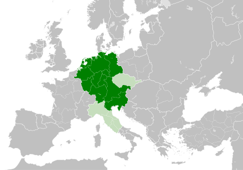
| текущий | 11:49, 4 мая 2021 | | 485 × 340 (1,23 Мб) | E-960 | Tribute was paid under Mieszko I, by the year 1000 Bolesław I the Brave stopped paying it |
| 13:14, 23 мая 2016 |  | 485 × 340 (1,23 Мб) | Der Golem | Duchy of Bohemia was part of the Holy Roman Empire, but not within the Kingdom of Germany | |
| 20:19, 22 мая 2016 |  | 485 × 340 (1,23 Мб) | Alphathon | == {{int:filedesc}} == {{Inkscape}} {{Information |Description={{en|A map of the Kingdom of Germany within the Holy Roman Empire and within Europe circa 1004 CE, after the incorporation of the [[:en:Duchy of Bohemia|Duchy of... |
Использование файла
Следующая страница использует этот файл:
Глобальное использование файла
Данный файл используется в следующих вики:
- Использование в az.wikipedia.org
- Использование в ba.wikipedia.org
- Использование в be.wikipedia.org
- Использование в ca.wikipedia.org
- Использование в cs.wikipedia.org
- Использование в en.wikipedia.org
- Использование в eo.wikipedia.org
- Использование в es.wikipedia.org
- Использование в et.wikipedia.org
- Использование в eu.wikipedia.org
- Использование в fr.wikipedia.org
- Использование в id.wikipedia.org
- Использование в ja.wikipedia.org
- Использование в ko.wikipedia.org
- Использование в la.wikipedia.org
- Использование в lv.wikipedia.org
- Использование в pl.wikipedia.org
- Использование в uk.wikipedia.org
- Использование в www.wikidata.org
.svg)