Файл:King John's campaign 1215-6.png
 Из Википедии, бесплатной энциклопедии
Размер этого предпросмотра: 458 × 600 пкс. Другие разрешения: 183 × 240 пкс | 366 × 480 пкс | 781 × 1023 пкс.
Исходный файл (781 × 1023 пкс, размер файла: 165 Кб, MIME-тип: image/png)
Этот файл находится на Викискладе. Сведения о нём показаны ниже. Викисклад — централизованное хранилище для свободных файлов, используемых в проектах Викимедиа. |
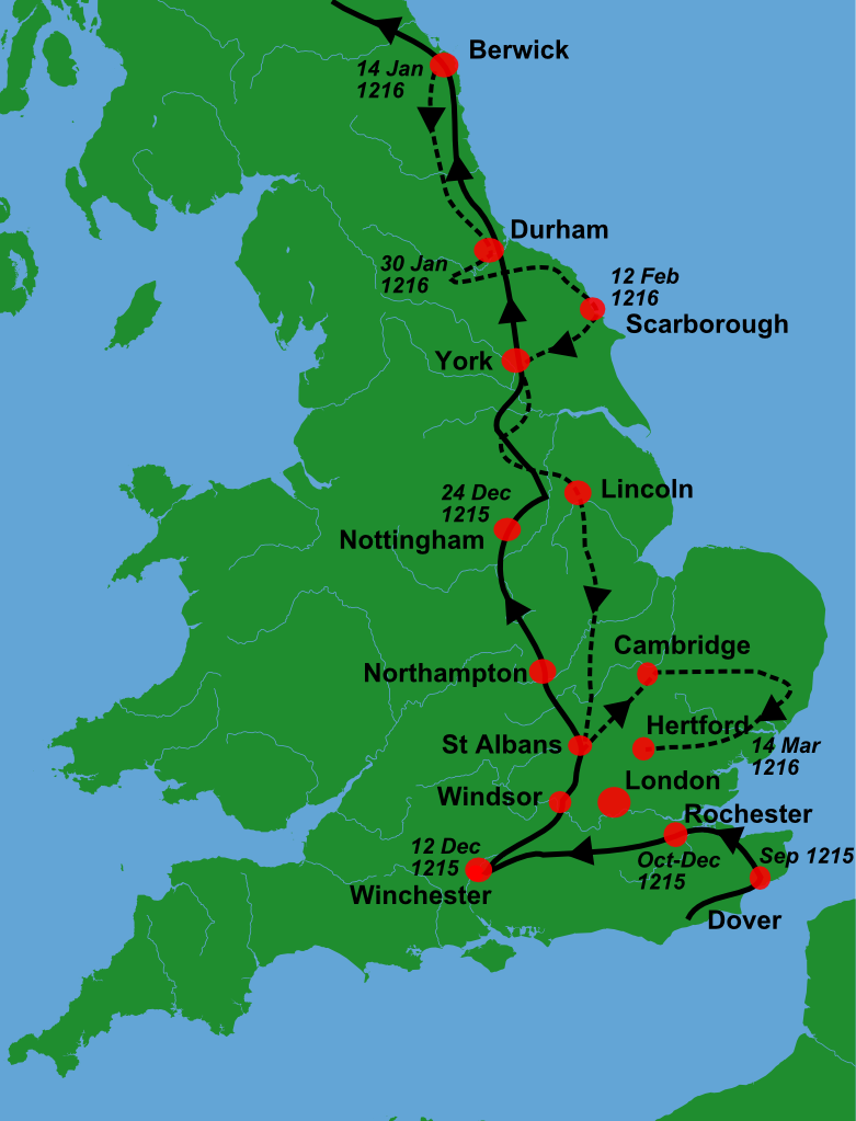
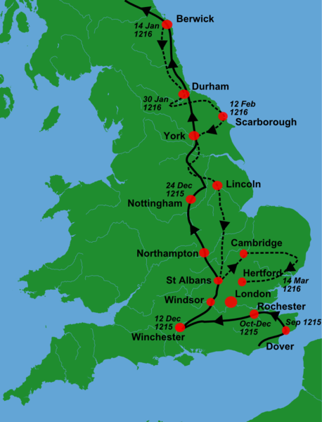
| Описание | A blank locator map for Great Britain, with King John's 1216-6 military campaigns superimposed on it (using information from Warren, "King John", p. 250. The idea is to superimpose Image:dot4gb.svg at the appropriate point. See w:Template:GBthumb for code to do this. These two images can replace any locator map posted by Lupin - see w:Special:Contributions/LupinBot. This is a vectorized version of Image:Gb4dot.png, with the scale changed from 200 km to 150 km/150 miles. The shoreline data come from the file gshhs_h.b from the GSHHS, and the rivers and the Irish border come from the CIA World DataBank II; both sources are in the public domain. Mercator projection. == |
| Дата | (UTC) |
| Источник | Собственная работа, используя:
|
| Автор |
|
| Это отретушированное изображение, что означает, что первоначальной версия изображения была изменена цифровым способом. Изменения: Trimmed, campaign superimposed. Оригинал доступен по ссылке: Gb4dot.svg:
|
Я, владелец авторских прав на это произведение, добровольно публикую его на условиях следующей лицензии:
| Я, владелец авторских прав на это произведение, передаю его в общественное достояние. Это разрешение действует по всему миру. В некоторых странах это не может быть возможно юридически, в таком случае: Я даю право кому угодно использовать данное произведение в любых целях без каких-либо условий, за исключением таких условий, которые требуются по закону. |
Исходный журнал загрузок
This image is a derivative work of the following images:
- File:Gb4dot.svg licensed with PD-self
Uploaded with derivativeFX
История файла
Нажмите на дату/время, чтобы посмотреть файл, который был загружен в тот момент.
| Дата/время | Миниатюра | Размеры | Участник | Примечание | |
|---|---|---|---|---|---|
| текущий | 10:08, 2 января 2011 | | 781 × 1023 (165 Кб) | Hchc2009 | {{Information |Description=A blank locator map for Great Britain, with King John's 1216-6 military campaigns superimposed on it (using information from Warren, "King John", p.250. The idea is to superimpose Image:dot4gb.svg at the appropriate point. |
Использование файла
Следующая страница использует этот файл:
Глобальное использование файла
Данный файл используется в следующих вики:
- Использование в az.wikipedia.org
- Использование в en.wikipedia.org
- Использование в fr.wikipedia.org
- Использование в gl.wikipedia.org
- Использование в hu.wikipedia.org
- Использование в nl.wikipedia.org
- Использование в tr.wikipedia.org
- Использование в zh.wikipedia.org