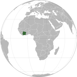
Ivory Coast

Republic of Côte d'Ivoire République de Côte d'Ivoire (French) | |
|---|---|
| Motto: "Union – Discipline – Travail" (French) "Unity – Discipline – Work" | |
| Anthem: L'Abidjanaise Song of Abidjan | |
 | |
 | |
| Capital | Yamoussoukro (political) Abidjan (economic) 6°51′N 5°18′W / 6.850°N 5.300°W |
| Largest city | Abidjan |
| Official languages | French |
| Recognised national languages | Bété • Dioula • Baoulé • Abron • Agni • Cebaara Senufo • others |
| Ethnic groups (2018) |
|
| Demonym(s) |
|
| Government | Unitary presidential republic under a parliamentary system |
| Alassane Ouattara | |
| Tiémoko Meyliet Koné | |
| Robert Beugré Mambé | |
| Legislature | Parliament of Ivory Coast |
| Senate | |
| National Assembly | |
| Independence | |
• from France | 7 August 1960 |
| Area | |
• Total | 322,463 km2 (124,504 sq mi) (68th) |
• Water (%) | 1.4[1] |
| Population | |
• 2018 estimate | 23,740,424[2] (54th) |
• 2015 census | 24,905,843 |
• Density | 63.9/km2 (165.5/sq mi) (139th) |
| GDP (PPP) | 2018 estimate |
• Total | $106.412 billion[3] |
• Per capita | $4,155[3] |
| GDP (nominal) | 2018 estimate |
• Total | $48.142 billion[3] |
• Per capita | $1,879[3] |
| Gini (2008) | 41.5[4] medium |
| HDI (2017) | low · 170th |
| Currency | West African CFA franc (XOF) |
| Time zone | UTC+0 (GMT) |
| Driving side | right |
| Calling code | +225 |
| ISO 3166 code | CI |
| Internet TLD | .ci |
Ivory Coast or Côte d'Ivoire,[a] officially the Republic of Côte d'Ivoire, is a country in West Africa.
The capital of Côte d'Ivoire is Yamoussoukro but its biggest city is Abidjan. Other cities can be found at List of cities in Côte d'Ivoire.
Geography
[change | change source]It borders the Gulf of Guinea to the south and five other African nations. Liberia is to the southwest, Guinea to the northwest, Mali to the north-northwest, Burkina Faso to the north-northeast, and Ghana to the east.
Districts
[change | change source]
Ivory Coast is divided into 12 districts and 2 district-level cities. The districts were created in 2011.
| Map no. | District | District capital |
|---|---|---|
| 1 | Abidjan (District Autonome d'Abidjan) | |
| 2 | Bas-Sassandra (District du Bas-Sassandra) | San-Pédro |
| 3 | Comoé (District du Comoé) | Abengourou |
| 4 | Denguélé (District du Denguélé) | Odienné |
| 5 | Gôh-Djiboua (District du Gôh-Djiboua) | Gagnoa |
| 6 | Lacs (District des Lacs) | Dimbokro |
| 7 | Lagunes (District des Lagunes) | Dabou |
| 8 | Montagnes (District des Montagnes) | Man |
| 9 | Sassandra-Marahoué (District du Sassandra-Marahoué) | Daloa |
| 10 | Savanes (District des Savanes) | Korhogo |
| 11 | Vallée du Bandama (District de la Vallée du Bandama) | Bouaké |
| 12 | Woroba (District du Woroba) | Séguéla |
| 13 | Yamoussoukro (District Autonome du Yamoussoukro) | |
| 14 | Zanzan (District du Zanzan) | Bondoukou |
Related pages
[change | change source]References
[change | change source]- ↑ "Côte d'Ivoire". The World Factbook. CIA Directorate of Intelligence. 24 July 2008. Archived from the original on 31 August 2020. Retrieved 8 August 2008.
- ↑ "Côte d'Ivoire". The World Factbook. CIA Directorate of Intelligence. Archived from the original on 31 August 2020. Retrieved 18 February 2017.
- ↑ 3.0 3.1 3.2 3.3 "Côte d'Ivoire". International Monetary Fund.
- ↑ "Gini Index". World Bank. Retrieved 2 March 2011.
- ↑ http://hdr.undp.org/sites/default/files/2018_human_development_statistical_update.pdf
- ↑ "Cote d'Ivoire definition". Dictionary.com. Retrieved 23 May 2014.
Notes
- ↑ The latter being pronounced /ˌkoʊt diːˈvwɑːr/ KOHT dee-VWAR in English and [kot divwaʁ] (
 listen) in French.[6]


