Minneapolis–Saint Paul

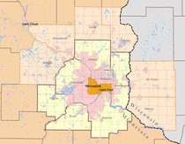
| Minneapolis-St. Paul U.S. Census Bureau Areas | ||
|---|---|---|
 | ||
| Minneapolis-St. Paul CSA, MN-WI[1] | ||
| Population | 4,078,788 | |
| Minnesota counties | Anoka · Benton · Carver · Chisago · Dakota · Goodhue · Hennepin · Isanti · Le Sueur · McLeod · Mille Lacs · Ramsey · Rice · Scott · Sherburne · Stearns · Steele · Washington · Wright | |
| Wisconsin counties | Pierce · St. Croix | |
| Minneapolis-St. Paul-Bloomington MSA, MN-WI[2] | ||
| Population | 3,690,261 | |
| Largest cities | Minneapolis | |
| Other cities | Saint Paul · Bloomington · Brooklyn Park · Plymouth · Woodbury · Maple Grove . Blaine . Lakeville . Eagan | |
| Density | 456/sq mi. (176/km²) | |
| Area | 8,093 total sq mi. (20,960 km²) | |
| Minnesota counties | Anoka · Carver · Chisago · Dakota · Hennepin · Isanti · Le Sueur · Mille Lacs · Ramsey · Scott · Sherburne · Washington · Wright | |
| Wisconsin counties | Pierce · St. Croix | |
| Minneapolis-St. Paul, MN Urbanized Area | ||
| Population | 2,914,866[3] | |
| Area codes | 612 · 651 · 763 · 952 | |
| Minnesota counties | Anoka · Carver · Dakota · Hennepin · Ramsey · Scott · Washington | |
Minneapolis-Saint Paul is the most populous urban area in the state of Minnesota, United States, and is made up of over 200 cities and townships. Built around the Mississippi, Minnesota and St. Croix rivers, the area is also nicknamed the Twin Cities for its two largest cities, Minneapolis and Saint Paul.
Related pages
[change | change source]References
[change | change source]- ↑ "Metropolitan and Micropolitan Statistical Areas Population Totals: 2020-2022". United States Census Bureau. February 24, 2022. Retrieved August 13, 2022.
- ↑ "2020 Population and Housing State Data". United States Census Bureau, Population Division. May 18, 2023. Archived from the original on June 29, 2022. Retrieved May 18, 2023.
- ↑ "Urban and Rural: List of 2020 Census Urban Areas". United States Census Bureau. Retrieved July 22, 2023.
Other websites
[change | change source]- Flyby video courtesy NASA/Goddard Scientific Visualization Studio
- Fact sheet about Minneapolis-St. Paul Metropolitan Area Comparison Archived 2009-02-21 at the Wayback Machine
- History of the National Weather Service in Minneapolis-St. Paul, Minnesota
- Twin Cities Daily Photograph — One photograph a day of the Twin Cities Metro Area
- GIS-based Demographic Guide to Twin Cities Region Archived 2018-04-12 at the Wayback Machine
