Dosya:Aster newyorkcity lrg.jpg
 Vikipedi, özgür ansiklopedi

Tam çözünürlük ((1.964 × 2.607 piksel, dosya boyutu: 3,31 MB, MIME tipi: image/jpeg))
Dosya geçmişi
Dosyanın herhangi bir zamandaki hâli için ilgili tarih/saat kısmına tıklayın.
| Tarih/Saat | Küçük resim | Boyutlar | Kullanıcı | Yorum | |
|---|---|---|---|---|---|
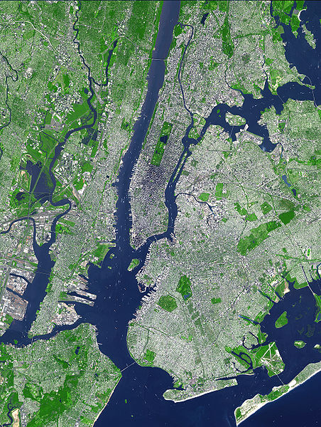
| güncel | 18.54, 8 Ağustos 2007 |  | 1.964 × 2.607 (3,31 MB) | HenrikRomby | {{Information |Description=This false-color satellite image shows Greater New York City. The Island of Manhattan juts southward from top center, bordered by the Hudson River to the west and the East River to the east (north is straight up in this scene.) |
Dosya kullanımı
Bu görüntü dosyasına bağlanan sayfa yok.
Küresel dosya kullanımı
Aşağıdaki diğer vikiler bu dosyayı kullanır:
- af.wikipedia.org üzerinde kullanımı
- ar.wikipedia.org üzerinde kullanımı
- ast.wikipedia.org üzerinde kullanımı
- bn.wikipedia.org üzerinde kullanımı
- ca.wikipedia.org üzerinde kullanımı
- da.wikipedia.org üzerinde kullanımı
- de.wikipedia.org üzerinde kullanımı
- el.wikipedia.org üzerinde kullanımı
- en.wikipedia.org üzerinde kullanımı
- Topography
- Hudson County, New Jersey
- User:TimAlderson/Userboxes
- Hudson Waterfront
- List of bridges, tunnels, and cuts in Hudson County, New Jersey
- User:NYCRuss/Sandbox/New York City
- Trees of New York City
- Talk:Trees of New York City
- Wikipedia:WikiProject New York City/Environment Task Force
- Wikipedia:WikiProject New York City/400 Task Force
- en.wikibooks.org üzerinde kullanımı
- eo.wikipedia.org üzerinde kullanımı
- es.wikipedia.org üzerinde kullanımı
- et.wikipedia.org üzerinde kullanımı
- fi.wikipedia.org üzerinde kullanımı
- fr.wikipedia.org üzerinde kullanımı
- fr.wikinews.org üzerinde kullanımı
- gl.wikipedia.org üzerinde kullanımı
- he.wikipedia.org üzerinde kullanımı
- hr.wikipedia.org üzerinde kullanımı
- hu.wikipedia.org üzerinde kullanımı
- hy.wikipedia.org üzerinde kullanımı
- id.wikipedia.org üzerinde kullanımı
- it.wikipedia.org üzerinde kullanımı
- ja.wikipedia.org üzerinde kullanımı
Bu dosyanın daha fazla küresel kullanımını görüntüle.

