Aristotle Lane


Aristotle Lane is a road in north Oxford, England.[1]
The lane links North Oxford, leading from the junction of Kingston Road and Hayfield Road (close to the junction with Polstead Road), with Port Meadow to the west, via bridges over the Oxford Canal and railway. The other access to the meadow from North Oxford is via Walton Well Road to the south.
St Philip & St James Primary School is located in Aristotle Lane, having previously below in Leckford Road to the south.[2] The Aristotle Lane Allotments are also located here.[3] To the north of the allotments is the Burgess Field Nature Park, formerly a landfill site. In addition, there is a recreation ground.[4]
Aristotle Lane Wildlife Corridor which is located within the residential development site of Burgess Mead is a 0.25-hectare (0.62-acre) strip of land either side of a minor drainage channel which runs for some 154 metres through the site. Included is a narrow strip of land at the northern site boundary which buffers the site from the adjacent Trap Grounds. This is an area of reed and sedge beds enclosed by damp woodland dominated by willows. Its interest includes breeding water rail, reed warbler and reed bunting and it has a certain historical ornithological value due to a past history of bird ringing at the site, as well as it being the location of a television documentary about the cuckoo. The pond/wetland created as part of the development has been successful and currently supports a dense central area of tall emergent vegetation typified by common reed and purple loosestrife, with other species at the margins including water mint and marsh marigold. The grasslands within the wildlife corridor have their origins partly in wildflower seeding and partly due to turfing (a legacy of the developers’ sales team). Seed of guaranteed native local provenance was used to create species-rich grasslands . The mammal shelves of sand/concrete bags installed alongside the stream channel beneath the new bridge, which is designed to permit terrestrial wildlife movement along the entire length of the watercourse. [5]
History[edit]
There is evidence of Iron Age tracks from the location of Aristotle Lane across Port Meadow to Binsey Ford.[6] The lane is named after Aristotle's Well in the vicinity, deriving from the name of the Ancient Greek philosopher Aristotle.[1]
On 3 June 1644, King Charles I passed this way with around 5,000 men, strategically withdrawing from Oxford, his temporary capital during the Civil War, across Port Meadow and the Thames.[7]
T. E. Lawrence (1888–1935, aka Lawrence of Arabia) used this route from his home as a child in Polstead Road on his way to Port Meadow to dig in the mounds there.[7]
Port Meadow Halt railway station was located just north of Aristotle Lane on the Varsity Line.[7] The London and North Western Railway opened the halt, originally called Summertown after the north Oxford district, on 20 August 1906.[8] It was renamed to Port Meadow Halt in January 1907. The station temporarily closed during World War I between 1 January 1917 and 5 May 1919. On 30 October 1926, London, Midland and Scottish Railway permanently closed the station.[9]
The land south of Aristotle Lane was acquired from Lucy's by Berkeley Homes and developed during 1996–1999 into the Waterside estate.[7]
Gallery[edit]
-
 View north along the Oxford Canal from Aristotle Bridge.
 -
 View south along the canal from Aristotle Bridge.
 -
 Oxford Canal in the snow south of Aristotle Bridge.
 -
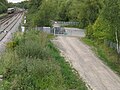 The site of the former Port Meadow Halt railway station, viewed from Aristotle Lane footbridge, looking north towards Wolvercote.


References[edit]
- ^ a b Aristotle Lane. In Christopher Hibbert and Edward Hibbert (editors), The Encyclopaedia of Oxford. Macmillan, 1988, page 19. ISBN 978-0-333-39917-0.
- ^ Aristotle Lane[permanent dead link], Oxford Waterside Residents' Association, Oxford, UK.
- ^ The Aristotle Lane Allotments[permanent dead link], Oxford Waterside Residents' Association, Oxford, UK.
- ^ Friends of Aristotle Lane Recreation Ground Archived 11 August 2011 at the Wayback Machine, Oxford, UK.
- ^ "The Friends of the Trap Grounds". UK: The Friends of The Trap Grounds. Retrieved 4 April 2020.
- ^ Aristotle Lane, Oxford. In Gazetteer of archaeological investigations in England, Volume 1, page 123. Council for British Archaeology, Archaeological Investigations Project, English Heritage, 1999.
- ^ a b c d "The History of Oxford Waterside". UK: Oxford Waterside Residents' Association. Archived from the original on 24 July 2012. Retrieved 23 October 2012.
- ^ Waters, Laurence (1986). Oxford. Rail Centres. London: Ian Allan. p. 128. ISBN 0-7110-1590-2.
- ^ Mitchell, Vic; Smith, Keith (July 2005). Oxford to Bletchley. Country Railway Routes. Middleton Press. ISBN 1-904474-57-8. Figure III.