Cade's Road

54°51′21″N 1°34′19″W / 54.855944°N 1.571972°W
This article has multiple issues. Please help improve it or discuss these issues on the talk page. (Learn how and when to remove these messages)
|
| Cade's Road | |
|---|---|
| Roman Road | |
 Roman Roads in Britain | |
| Route information | |
| Length | 100 mi (160 km) |
| Margary number | 80 ( a ) -- Petuaria to Old Durham ( b ) -- Concangis to Pons Aelius |
| Major junctions | |
| From | Petuaria ( Brough, Humber Estuary ) |
| Derventio ( Stamford Bridge ), (North-East)--Malton Roman Fort [a] (East)--Bridlington (West)--Eboracum ( York ) Lugunduno , River Tees (East)--Dunum Sinus, ( Tees Bay, North Sea ) (West)--Piercebridge Roman Fort (North-West)--Vinovia ( Binchester Roman Fort ) Old Durham, River Wear ( 80 b ) Concangis ( Chester-le-Street Roman Fort ) (North-East)--Arbeia ( South Shields Roman Fort ) | |
| To | Pons Aelius ( Newcastle Roman Fort ), River Tyne |
| Location | |
| Country | United Kingdom |
| Road network | |
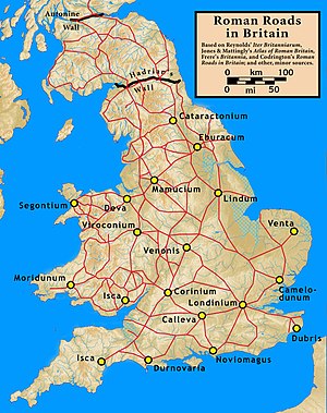
Cade's Road is a Roman Road in north-east England.[1][2] It is named after John Cade of Durham, an 18th-century antiquarian who in 1785 proposed its existence and possible course from the Humber Estuary northwards to the River Tyne, a distance of about 100 miles (160 km). The road's Roman name is unknown. Although evidence exists for such a road on some parts of the proposed route, there is still some doubt regarding its exact course.[1][3][4]

Examples of place names with the suffix "le-Street": [b]
Route
[edit]From the Humber to the Tees
[edit]Cade's Road began at Brough on the north bank of the River Humber, where there was a ferry, a Roman fort and civilian settlement (Petuaria) alongside a major Celtic settlement. The road ran northwards through Thorpe le Street and Market Weighton, before gradually turning westwards (possibly following the line of another Roman road) until it reached York (Roman Eboracum). From York it continued northwards to Thornton-le-Street near Thirsk and on to cross the River Tees (on a stone bridge now gone, but stones of which are incorporated into local buildings)[12] near Middleton St George and Middleton One Row, where 'Pounteys Lane' is possibly named after the Roman Pons Tees (Bridge of Tees).
From the Tees to the Tyne
[edit]From the Tees the road heads north through Sadberge and then Great Stainton (also known as Stainton-le-Street) near Sedgefield. The route of the road in the Durham area is unknown, but it is thought the road passed east of Durham City, crossing the River Wear at Kepier.[13] The road ran past the Roman fort of Concangis, located at Chester-le-Street.[14] Concangis is the only known Roman fort on the road between York and Newcastle.
From Concangis the road headed north through Birtley to Wrekenton, once a village but now a suburb of Gateshead. From Wrekenton, a branch road, known as the Wrekendyke, headed north-east to the Roman fort and harbour of Arbeia at South Shields. It has been conjectured that the site of a Roman fort exists on the golf course at Wrekenton, but this has never been confirmed.
Cade's Road continued north from Wrekenton along Gateshead High Street and crossed the Tyne over the Roman bridge of Pons Aelius (Newcastle upon Tyne). It is not believed that the road continued north of Hadrian's Wall.
See also
[edit]References
[edit]Notes
[edit]- ^ Malton Roman Fort was previously known as Derventio Brigantum , see Derventio (disambiguation)
- ^ Place names with the suffix "le-Street" were so named because they were on (or near) a Roman road. [5]
- ^ The route can be seen heading North to Bullamoor (near Northallerton) and beyond, followed intermittently by a parish boundary. (Drag map down)
- ^ The route follows the A1079 North-West towards Hayton and Barmby Moor (West of Pocklington), where the route separated from the modern road and headed slightly North of Wilberfoss towards Low Catton and the Roman fort of Derventio at Stamford Bridge[11]
Citations
[edit]- ^ a b Selkirk 2001, pp. 212–217.
- ^ "MYO4439 – Roman Road". York Historic Environment Record. City of York Council. 3 November 2021.
- ^ *"Cade's Road : Stamford bridge to River Tees". Roads of Roman Britain. Retrieved 1 July 2022.
- ^ *"Cade's Road : River Tees to Durham". Bowburn Local History. Retrieved 1 July 2022.
- ^ "Key to English Place-Names : Chester-le-Street". University of Nottingham.
[for Chester-le-Street] : "Street" from strēt (Anglian), a Roman road
- ^ MAGiC MaP : Table of Contents
- Designations
- -- Listed Buildings (COLOURED SQUARE)
- -- Scheduled Monuments (SHADED POLYGON)
- OS Colour Mapping
- ^ "MAGiC MaP : Chester-le-Street". Natural England - Magic in the Cloud.
- ^ a b MAGiC MaP : Table of Contents
- Administrative
- -- Parish Boundary (PURPLE LINE)
- OS Colour Mapping
- ^ "MAGiC MaP : Thornton le Street near Thirsk". Natural England - Magic in the Cloud.
- ^ "MAGiC MaP : Thorpe le Street near Pocklington". Natural England - Magic in the Cloud.
- ^ *Roman Britain (Historical Map and Guide). Ordnance Survey. 2010. ISBN 9780319290378.
- ^ Selkirk 2001, p. 217.
- ^ Selkirk 2001, pp. 214–217.
- ^ Selkirk 2001, pp. 212–213.
Sources
[edit]- Graham, Frank (1979). The Roman Wall: comprehensive history and guide. Newcastle upon Tyne: Frank Graham. pp. 242–244. ISBN 0-85983-140-X.
- Selkirk, Raymond (1995). On the Trail of the Legions. Ipswich: Anglia Publishing. pp. 94, 95, 215, 329. ISBN 1-897874-08-1.
- Selkirk, Raymond (2001). Chester-le-Street and Its Place in History. Washington, Tyne and Wear: Northern Archaeology Group. pp. 212–217, 221. ISBN 1-900456-05-2.
External links
[edit]This article derives from local newspaper reports and local amateur group reports listed below:
- https://web.archive.org/web/20070217044906/http://www.n-a-g.freeserve.co.uk/DOCUMENTS/ISS02_OCT98/ISS02_OCT98.htm#6
- https://web.archive.org/web/20070926225336/http://www.communigate.co.uk/ne/archaeologynorth/page5.phtml
- https://web.archive.org/web/20070321174841/http://www.biffvernon.freeserve.co.uk/northallerton.htm
- https://web.archive.org/web/20070929083619/http://www.communigate.co.uk/ne/sadberge/page3.phtml
- On verge of rewriting history, The Northern Echo, 2005-09-22. Retrieved on 2007-07-29.
- http://www.northeastengland.talktalk.net/Darlington%20and%20the%20Tees%20Vale.htm