Jakartovice

Jakartovice | |
|---|---|
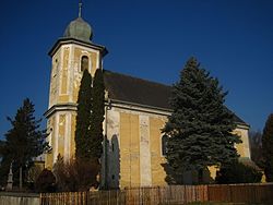
 Church of the Nativity of the Virgin Mary | |
| Coordinates: 49°54′54″N 17°41′3″E / 49.91500°N 17.68417°E | |
| Country | |
| Region | Moravian-Silesian |
| District | Opava |
| First mentioned | 1250 |
| Area | |
| • Total | 50.04 km2 (19.32 sq mi) |
| Elevation | 356 m (1,168 ft) |
| Population (2024-01-01)[1] | |
| • Total | 1,080 |
| • Density | 22/km2 (56/sq mi) |
| Time zone | UTC+1 (CET) |
| • Summer (DST) | UTC+2 (CEST) |
| Postal code | 747 53 |
| Website | www |
Jakartovice (German: Eckersdorf, Polish: Jakartowice) is a municipality and village in Opava District in the Moravian-Silesian Region of the Czech Republic. It has about 1,100 inhabitants.
Administrative parts
[edit]The villages of Bohdanovice, Deštné and Hořejší Kunčice are administrative parts of Jakartovice.
Geography
[edit]Jakartovice is located about 14 kilometres (9 mi) west of Opava and 38 km (24 mi) west of Ostrava. It lies in the Nízký Jeseník range. The highest point is at 563 m (1,847 ft) above sea level. The southern municipal border is formed by the Kružberk Reservoir, built on the Moravice River.
History
[edit]The first written mention of Jakartovice is from 1250. Bohdanovice was first mentioned in 1265, Deštné at the beginning of the 14th century and Hořejší Kunčice in 1403.[2]
In 1974 the villages of Bohdanovice, Deštné, Hořejší Kunčice, and the territory of former villages of Kerhartice and Medlice were joined to Jakartovice and since then they make up one municipality.[3]
Demographics
[edit]
|
|
| ||||||||||||||||||||||||||||||||||||||||||||||||||||||
| Source: Censuses[4][5] | ||||||||||||||||||||||||||||||||||||||||||||||||||||||||
Transport
[edit]The I/46 road from Olomouc to Opava passes through the municipality.
Jakartovice is located on the railway line Opava–Svobodné Heřmanice, but trains run on it only on weekends and holidays during the summer season.[6]
Sights
[edit]
The most valuable buildings are the Church of the Nativity of the Virgin Mary, built in the Baroque style in 1755, and the complex of historic buildings in Deštné – the Baroque Deštné Castle from the 18th century (rebuilt from a fortress from 1408) with a park, and the Gothic Church of the Visitation of Our Lady from the second half of the 14th century.[2]
References
[edit]- ^ "Population of Municipalities – 1 January 2024". Czech Statistical Office. 2024-05-17.
- ^ a b "Obec" (in Czech). Obec Jakartovice. Retrieved 2020-11-26.
- ^ "Home Page" (in Czech). Obec Jakartovice. Retrieved 2020-11-26.
- ^ "Historický lexikon obcí České republiky 1869–2011" (in Czech). Czech Statistical Office. 2015-12-21.
- ^ "Population Census 2021: Population by sex". Public Database. Czech Statistical Office. 2021-03-27.
- ^ "Jízdní řády" (in Czech). Railway Capital. Retrieved 2024-04-11.


