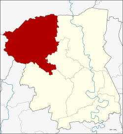
Kamphaeng Saen district

Kamphaeng Saen กำแพงแสน | |
|---|---|
 District location in Nakhon Pathom province | |
| Coordinates: 13°59′2″N 99°59′38″E / 13.98389°N 99.99389°E | |
| Country | Thailand |
| Province | Nakhon Pathom |
| Area | |
| • Total | 405.019 km2 (156.379 sq mi) |
| Population (2017) | |
| • Total | 129,081 |
| • Density | 318.70/km2 (825.4/sq mi) |
| Time zone | UTC+7 (ICT) |
| Postal code | 73140 |
| Geocode | 7302 |

Kamphaeng Saen (Thai: กำแพงแสน, pronounced [kām.pʰɛ̄ːŋ sɛ̌ːn]) is the northwesternmost district (amphoe) of Nakhon Pathom province, central Thailand.
History
[edit]Kamphaeng Saen was a moated centre of Dvaravati culture, dating from 410-870 CE, with the foundation of a Buddhist stupa identified.[1]: 304
Geography
[edit]Neighbouring districts are (from the north clockwise): Song Phi Nong of Suphanburi province; Bang Len, Don Tum, and Mueang Nakhon Pathom of Nakhon Pathom Province; Ban Pong of Ratchaburi province; and Tha Maka of Kanchanaburi province.
Kasetsart University's Kamphaeng Saen campus is in this district.
Administration
[edit]The district is divided into 15 subdistricts (tambons), which are further subdivided into 202 villages (mubans). Kamphaeng Saen is also a township (thesaban tambon), which covers parts of tambons Kamphaeng Saen and Thung Kraphang Hom.
| 1. | Thung Kraphang Hom | ทุ่งกระพังโหม | |
| 2. | Kratip | กระตีบ | |
| 3. | Thung Luk Nok | ทุ่งลูกนก | |
| 4. | Huai Khwang | ห้วยขวาง | |
| 5. | Thung Khwang | ทุ่งขวาง | |
| 6. | Sa Si Mum | สระสี่มุม | |
| 7. | Thung Bua | ทุ่งบัว | |
| 8. | Don Khoi | ดอนข่อย | |
| 9. | Sa Phatthana | สระพัฒนา | |
| 10. | Huai Mon Thong | ห้วยหมอนทอง | |
| 11. | Huai Muang | ห้วยม่วง | |
| 12. | Kamphaeng Saen | กำแพงแสน | |
| 13. | Rang Phikun | รางพิกุล | |
| 14. | Nong Krathum | หนองกระทุ่ม | |
| 15. | Wang Nam Khiao | วังน้ำเขียว |
References
[edit]- ^ Higham, C., 2014, Early Mainland Southeast Asia, Bangkok: River Books Co., Ltd., ISBN 9786167339443