[5] Name on the Register[6] Image Date listed[7] Location Neighborhood Description 1 Adler Planetarium Adler Planetarium February 27, 1987 (#87000819 ) 1300 S. Lake Shore Drive 41°51′58″N 87°36′24″W / 41.866111°N 87.606667°W / 41.866111; -87.606667 (Adler Planetarium ) Near South Side Built in 1930 2 America Fore Building America Fore Building June 21, 2016 (#16000383 ) 844 N. Rush Street 41°53′53″N 87°37′34″W / 41.898056°N 87.626245°W / 41.898056; -87.626245 (America Fore Building ) Near North Side 3 Auditorium Building, Roosevelt University Auditorium Building, Roosevelt University April 17, 1970 (#70000230 ) 430 S. Michigan Avenue 41°52′32″N 87°37′29″W / 41.875556°N 87.624722°W / 41.875556; -87.624722 (Auditorium Building, Roosevelt University ) Chicago Loop Built in 1889 4 B.F. Goodrich Company Showroom B.F. Goodrich Company Showroom May 28, 2009 (#09000347 ) 1925 S. Michigan Avenue 41°51′21″N 87°37′24″W / 41.855958°N 87.623425°W / 41.855958; -87.623425 (B.F. Goodrich Company Showroom ) Near South Side 5 Balaban and Katz Chicago Theatre Balaban and Katz Chicago Theatre June 6, 1979 (#79000822 ) 175 N. State Street 41°53′08″N 87°37′38″W / 41.885556°N 87.627222°W / 41.885556; -87.627222 (Balaban and Katz Chicago Theatre ) Chicago Loop Built in 1921 6 Blackstone Hotel Blackstone Hotel May 8, 1986 (#86001005 ) 80 E. Balbo Drive 41°52′24″N 87°37′28″W / 41.873333°N 87.624444°W / 41.873333; -87.624444 (Blackstone Hotel ) Chicago Loop Built in 1910 7 Boyce Building Boyce Building February 29, 1996 (#96000080 ) 500–510 N. Dearborn Street 41°53′28″N 87°37′48″W / 41.891111°N 87.63°W / 41.891111; -87.63 (Boyce Building ) Near North Side 8 Buckingham Building Buckingham Building August 10, 2000 (#00000942 ) 63 E. Van Buren Street 41°52′36″N 87°37′30″W / 41.876667°N 87.625°W / 41.876667; -87.625 (Buckingham Building ) Chicago Loop 9 Building at 14–16 Pearson Street Building at 14–16 Pearson Street May 8, 1980 (#80001343 ) 14–16 E. Pearson Street 41°53′51″N 87°37′40″W / 41.8975°N 87.627778°W / 41.8975; -87.627778 (Building at 14–16 Pearson Street ) Near North Side 10 Building at 257 East Delaware Place Building at 257 East Delaware Place June 26, 1987 (#87001113 ) 257 E. Delaware Place 41°53′57″N 87°37′10″W / 41.899167°N 87.619444°W / 41.899167; -87.619444 (Building at 257 East Delaware Place ) Near North Side 11 Buildings at 860–880 N. Lake Shore Drive Buildings at 860–880 N. Lake Shore Drive August 28, 1980 (#80001344 ) 860–880 N. Lake Shore Drive 41°53′55″N 87°37′08″W / 41.898658°N 87.618839°W / 41.898658; -87.618839 (Buildings at 860–880 N. Lake Shore Drive ) Near North Side Built in 1949 12 Burlingham Building Burlingham Building February 14, 1985 (#85000264 ) 104 W. Oak Street 41°54′04″N 87°37′54″W / 41.901111°N 87.631667°W / 41.901111; -87.631667 (Burlingham Building ) Near North Side 13 Bush Temple of Music Bush Temple of Music December 31, 2013 (#13001001 ) 100 W. Chicago Avenue , 800 N. Clark Street 41°53′49″N 87°37′54″W / 41.896819°N 87.631696°W / 41.896819; -87.631696 (Bush Temple of Music ) Near North Side 14 Calumet Plant, R. R. Donnelly & Sons Company Calumet Plant, R. R. Donnelly & Sons Company February 17, 1983 (#83000308 ) 350 E. Cermak Road 41°51′13″N 87°37′05″W / 41.853611°N 87.618056°W / 41.853611; -87.618056 (Calumet Plant, R. R. Donnelly & Sons Company ) Near South Side 15 Carling Hotel Carling Hotel January 24, 2017 (#100000563 ) 1512 N. LaSalle Street 41°54′35″N 87°38′01″W / 41.909662°N 87.633549°W / 41.909662; -87.633549 (Carling Hotel ) Near North Side 16 Carson, Pirie, Scott and Company Building Carson, Pirie, Scott and Company Building April 17, 1970 (#70000231 ) 1 S. State Street 41°52′54″N 87°37′39″W / 41.881667°N 87.6275°W / 41.881667; -87.6275 (Carson, Pirie, Scott and Company Building ) Chicago Loop Now occupied by a Target department store 17 Chapin and Gore Building Chapin and Gore Building June 27, 1979 (#79000823 ) 63 E. Adams Street 41°52′45″N 87°37′31″W / 41.879167°N 87.625278°W / 41.879167; -87.625278 (Chapin and Gore Building ) Chicago Loop 18 James Charnley House James Charnley House April 17, 1970 (#70000232 ) 1365 N. Astor Street 41°54′28″N 87°37′40″W / 41.907778°N 87.627778°W / 41.907778; -87.627778 (James Charnley House ) Near North Side 19 Chicago Avenue Water Tower and Pumping Station Chicago Avenue Water Tower and Pumping Station April 23, 1975 (#75000644 ) 806 N. Michigan Avenue 41°53′50″N 87°37′26″W / 41.897222°N 87.623889°W / 41.897222; -87.623889 (Chicago Avenue Water Tower and Pumping Station ) Near North Side Survived the Great Fire of October 1871 20 Chicago Board of Trade Building Chicago Board of Trade Building June 16, 1978 (#78003181 ) 141 W. Jackson Boulevard 41°52′41″N 87°37′56″W / 41.878139°N 87.632278°W / 41.878139; -87.632278 (Chicago Board of Trade Building ) Chicago Loop 21 Chicago Club Chicago Club February 28, 2005 (#05000109 ) 81 E. Van Buren Street 41°52′37″N 87°37′29″W / 41.876944°N 87.624722°W / 41.876944; -87.624722 (Chicago Club ) Chicago Loop 1929 22 Chicago Federal Center Chicago Federal Center March 24, 2011 (#08001165 ) Entire block bounded by S. Dearborn Street , W. Jackson Street , S. Clark Street and W. Adams Street and the contiguous half-block east of S. Dearborn Street 41°52′44″N 87°37′48″W / 41.878889°N 87.63°W / 41.878889; -87.63 (Chicago Federal Center ) Chicago Loop 23 Chicago Harbor Lighthouse Chicago Harbor Lighthouse July 19, 1984 (#84000986 ) North Breakwater 41°53′22″N 87°35′26″W / 41.889444°N 87.590556°W / 41.889444; -87.590556 (Chicago Harbor Lighthouse ) Near North Side 24 Chicago Public Library, Central Building Chicago Public Library, Central Building July 31, 1972 (#72000449 ) 78 E. Washington Street 41°53′02″N 87°37′30″W / 41.883889°N 87.625°W / 41.883889; -87.625 (Chicago Public Library, Central Building ) Chicago Loop 25 Chicago Savings Bank Building Chicago Savings Bank Building September 5, 1975 (#75000645 ) 7 W. Madison Street 41°52′54″N 87°37′42″W / 41.881667°N 87.628333°W / 41.881667; -87.628333 (Chicago Savings Bank Building ) Chicago Loop 26 Chicago Varnish Company Building Chicago Varnish Company Building June 14, 2001 (#01000649 ) 33 W. Kinzie Street 41°53′20″N 87°37′46″W / 41.888889°N 87.629444°W / 41.888889; -87.629444 (Chicago Varnish Company Building ) Near North Side 27 Henry B. Clarke House Henry B. Clarke House May 6, 1971 (#71000290 ) 1827 Indiana Avenue 41°51′26″N 87°37′19″W / 41.857222°N 87.621944°W / 41.857222; -87.621944 (Henry B. Clarke House ) Near South Side 28 Coca Cola Company Building Coca Cola Company Building February 22, 1991 (#91000114 ) 1322–1336 S. Wabash Avenue 41°51′54″N 87°37′34″W / 41.865°N 87.626111°W / 41.865; -87.626111 (Coca Cola Company Building ) Near South Side 29 Continental and Commercial National Bank Continental and Commercial National Bank February 14, 2007 (#07000064 ) 208 S. LaSalle Street 41°52′45″N 87°37′56″W / 41.879167°N 87.632222°W / 41.879167; -87.632222 (Continental and Commercial National Bank ) Chicago Loop 30 Conway Building Conway Building February 9, 1984 (#84000988 ) 111 W. Washington Street 41°52′58″N 87°37′53″W / 41.882778°N 87.631389°W / 41.882778; -87.631389 (Conway Building ) Chicago Loop 31 Cook County Criminal Court Building Cook County Criminal Court Building November 13, 1984 (#84000281 ) 54 W. Hubbard Street 41°53′25″N 87°37′49″W / 41.890278°N 87.630278°W / 41.890278; -87.630278 (Cook County Criminal Court Building ) Near North Side 32 Crane Company Building Crane Company Building January 28, 2002 (#01001538 ) 836 S. Michigan Avenue 41°52′14″N 87°37′28″W / 41.870556°N 87.624444°W / 41.870556; -87.624444 (Crane Company Building ) Chicago Loop 33 Curtiss–Wright Aeronautical University Building Curtiss–Wright Aeronautical University Building October 16, 2013 (#13000827 ) 1340 S. Michigan Avenue 41°51′53″N 87°37′28″W / 41.864591°N 87.624391°W / 41.864591; -87.624391 (Curtiss–Wright Aeronautical University Building ) Near South Side 1929–53 location of African-American aviation school 34 Dearborn Station Dearborn Station March 26, 1976 (#76000688 ) 47 W. Polk Street 41°52′20″N 87°37′42″W / 41.872222°N 87.628333°W / 41.872222; -87.628333 (Dearborn Station ) Chicago Loop 35 Delaware Building Delaware Building July 18, 1974 (#74000749 ) 36 W. Randolph Street 41°53′05″N 87°37′45″W / 41.884722°N 87.629167°W / 41.884722; -87.629167 (Delaware Building ) Chicago Loop 36 Drake Hotel Drake Hotel May 8, 1980 (#80001345 ) 140 E. Walton Street 41°54′02″N 87°37′27″W / 41.900556°N 87.624167°W / 41.900556; -87.624167 (Drake Hotel ) Near North Side 37 Jean Baptiste Point Du Sable Homesite Jean Baptiste Point Du Sable Homesite May 11, 1976 (#76000690 ) 401 N. Michigan Avenue 41°53′23″N 87°37′24″W / 41.889722°N 87.623333°W / 41.889722; -87.623333 (Jean Baptiste Point Du Sable Homesite ) Near North Side 38 Emmel Building Emmel Building November 13, 1984 (#84000283 ) 1357 N. Wells Street 41°54′26″N 87°38′03″W / 41.907222°N 87.634167°W / 41.907222; -87.634167 (Emmel Building ) Near North Side 39 Fairbanks, Morse and Company Building Fairbanks, Morse and Company Building November 16, 1988 (#88002233 ) 900 S. Wabash Avenue 41°52′13″N 87°37′34″W / 41.870278°N 87.626111°W / 41.870278; -87.626111 (Fairbanks, Morse and Company Building ) Chicago Loop 40 Field Museum of Natural History Field Museum of Natural History September 5, 1975 (#75000647 ) 1400 S. Lake Shore Drive 41°51′59″N 87°37′01″W / 41.866389°N 87.616944°W / 41.866389; -87.616944 (Field Museum of Natural History ) Near South Side 41 Marshall Field Garden Apartments Marshall Field Garden Apartments December 17, 1991 (#91001691 ) 1394 N. Sedgwick Street, 1395 N. Hudson Avenue, 412 W. Evergreen Street and 413 W. Blackhawk Street 41°54′29″N 87°38′20″W / 41.908056°N 87.638889°W / 41.908056; -87.638889 (Marshall Field Garden Apartments ) Near North Side 42 Fisher Building Fisher Building March 16, 1976 (#76000691 ) 343 S. Dearborn Street 41°52′37″N 87°37′44″W / 41.876944°N 87.628889°W / 41.876944; -87.628889 (Fisher Building ) Chicago Loop 43 Fort Dearborn Hotel Fort Dearborn Hotel November 12, 1982 (#82000390 ) 401 S. LaSalle Street 41°52′36″N 87°37′52″W / 41.876667°N 87.631111°W / 41.876667; -87.631111 (Fort Dearborn Hotel ) Chicago Loop 44 Fourth Presbyterian Church of Chicago Fourth Presbyterian Church of Chicago September 5, 1975 (#75000648 ) 126 E. Chestnut Street 41°53′55″N 87°37′28″W / 41.898611°N 87.624444°W / 41.898611; -87.624444 (Fourth Presbyterian Church of Chicago ) Near North Side 45 Gage Group-Ascher, Keith, and Gage Buildings Gage Group-Ascher, Keith, and Gage Buildings November 14, 1985 (#85002840 ) 18,24,30 S. Michigan Avenue 41°52′52″N 87°37′30″W / 41.881111°N 87.625°W / 41.881111; -87.625 (Gage Group-Ascher, Keith, and Gage Buildings ) Chicago Loop 46 Germania Club Germania Club October 22, 1976 (#76000692 ) 108 W. Germania Place 41°54′38″N 87°37′57″W / 41.910556°N 87.6325°W / 41.910556; -87.6325 (Germania Club ) Near North Side 47 John J. Glessner House John J. Glessner House April 17, 1970 (#70000233 ) 1800 S. Prairie Avenue 41°51′27″N 87°37′16″W / 41.8575°N 87.621111°W / 41.8575; -87.621111 (John J. Glessner House ) Near South Side 48 Gold Coast Historic District Gold Coast Historic District January 30, 1978 (#78001121 ) Roughly bounded by North Avenue , Lake Shore Drive , Clark and Oak Streets. 41°54′21″N 87°37′41″W / 41.905833°N 87.628056°W / 41.905833; -87.628056 (Gold Coast Historic District ) Near North Side 49 Grant Park Grant Park July 21, 1993 (#92001075 ) Roughly, from the Chicago River to E. McFetridge Drive at Lake Michigan 41°52′31″N 87°37′05″W / 41.875278°N 87.618056°W / 41.875278; -87.618056 (Grant Park ) Chicago Loop 50 Raymond M. Hilliard Center Historic District Raymond M. Hilliard Center Historic District September 13, 1999 (#99001072 ) Jct. of Cermak Road and S. State Street 41°51′15″N 87°36′59″W / 41.854167°N 87.616389°W / 41.854167; -87.616389 (Raymond M. Hilliard Center Historic District ) Near South Side 51 Holy Name Cathedral Holy Name Cathedral May 25, 2000 (#00000477 ) 735 N. State Street 41°53′46″N 87°37′40″W / 41.896111°N 87.627778°W / 41.896111; -87.627778 (Holy Name Cathedral ) Near North Side 52 Hotel St. Benedict Flats Hotel St. Benedict Flats September 1, 1995 (#88003311 ) 801 N. Wabash Avenue 41°53′49″N 87°37′35″W / 41.896944°N 87.626389°W / 41.896944; -87.626389 (Hotel St. Benedict Flats ) Near North Side 53 IBM Building IBM Building March 11, 2010 (#09000166 ) 330 N. Wabash Avenue 41°53′19″N 87°37′39″W / 41.888611°N 87.627583°W / 41.888611; -87.627583 (IBM Building ) Near North Side 54 Inland Steel Building Inland Steel Building February 18, 2009 (#09000024 ) 30 W. Monroe Street 41°52′51″N 87°37′44″W / 41.880756°N 87.628956°W / 41.880756; -87.628956 (Inland Steel Building ) Chicago Loop 55 Jewelers' Building Jewelers' Building August 7, 1974 (#74000752 ) 17 S. Wabash Avenue 41°52′53″N 87°37′33″W / 41.881389°N 87.625833°W / 41.881389; -87.625833 (Jewelers' Building ) Chicago Loop 56 William W. Kimball House William W. Kimball House December 9, 1971 (#71000291 ) 1801 S. Prairie Avenue 41°51′24″N 87°37′12″W / 41.856667°N 87.62°W / 41.856667; -87.62 (William W. Kimball House ) Near South Side 57 Lakeside Press Building Lakeside Press Building June 23, 1976 (#76000694 ) 731 S. Plymouth Court 41°52′21″N 87°37′42″W / 41.8725°N 87.628333°W / 41.8725; -87.628333 (Lakeside Press Building ) Chicago Loop 58 Bryan Lathrop House Bryan Lathrop House February 15, 1974 (#74000753 ) 120 E. Bellevue Place 41°54′06″N 87°37′31″W / 41.901667°N 87.625278°W / 41.901667; -87.625278 (Bryan Lathrop House ) Near North Side 59 Victor F. Lawson House YMCA Victor F. Lawson House YMCA May 8, 2017 (#100000959 ) 30 W. Chicago Avenue 41°53′48″N 87°37′46″W / 41.896723°N 87.629434°W / 41.896723; -87.629434 (Victor F. Lawson House YMCA ) Near North Side 60 Leiter II Building Leiter II Building January 7, 1976 (#76000695 ) 401 S. State Street 41°52′35″N 87°37′39″W / 41.876389°N 87.6275°W / 41.876389; -87.6275 (Leiter II Building ) Chicago Loop 61 Loop Retail Historic District Loop Retail Historic District November 27, 1998 (#98001351 ) Roughly bounded by Lake Street , Wabash Avenue, Congress Parkway , and State Street 41°52′52″N 87°37′37″W / 41.881111°N 87.626944°W / 41.881111; -87.626944 (Loop Retail Historic District ) Chicago Loop 62 Ludington Building Ludington Building May 8, 1980 (#80001347 ) 1104 S. Wabash Avenue 41°52′08″N 87°37′35″W / 41.868889°N 87.626389°W / 41.868889; -87.626389 (Ludington Building ) Chicago Loop 63 Lumber Exchange Building and Tower Addition Lumber Exchange Building and Tower Addition December 6, 2007 (#07001238 ) 11 S. LaSalle Street 41°52′54″N 87°37′55″W / 41.881667°N 87.631944°W / 41.881667; -87.631944 (Lumber Exchange Building and Tower Addition ) Chicago Loop 64 Albert F. Madlener House Albert F. Madlener House October 15, 1970 (#70000234 ) 4 W. Burton Street 41°54′35″N 87°37′45″W / 41.909722°N 87.629167°W / 41.909722; -87.629167 (Albert F. Madlener House ) Near North Side 65 Manhattan Building Manhattan Building March 16, 1976 (#76000697 ) 431 S. Dearborn Street 41°52′34″N 87°37′45″W / 41.876111°N 87.629167°W / 41.876111; -87.629167 (Manhattan Building ) Chicago Loop 66 Marquette Building Marquette Building August 17, 1973 (#73000697 ) 140 S. Dearborn Street 41°52′48″N 87°37′46″W / 41.88°N 87.629444°W / 41.88; -87.629444 (Marquette Building ) Chicago Loop 67 Marshall Hotel Marshall Hotel November 27, 2017 (#100001833 ) 1232 N. LaSalle Street 41°54′17″N 87°37′59″W / 41.904829°N 87.633058°W / 41.904829; -87.633058 (Marshall Hotel ) Near North Side 68 Marshall Field Company Store Marshall Field Company Store June 2, 1978 (#78001123 ) 111 N. State Street 41°53′01″N 87°37′37″W / 41.883611°N 87.626944°W / 41.883611; -87.626944 (Marshall Field Company Store ) Chicago Loop 69 Maxwell-Briscoe Automobile Company Showroom Maxwell-Briscoe Automobile Company Showroom November 18, 2002 (#02001349 ) 1737 S. Michigan Avenue 41°51′36″N 87°37′25″W / 41.86°N 87.623611°W / 41.86; -87.623611 (Maxwell-Briscoe Automobile Company Showroom ) Near South Side 70 Isaac N. Maynard Rowhouses Isaac N. Maynard Rowhouses February 25, 2004 (#04000077 ) 119,121,123 W. Delaware Place 41°54′04″N 87°37′57″W / 41.901111°N 87.6325°W / 41.901111; -87.6325 (Isaac N. Maynard Rowhouses ) Near North Side 71 McClurg Building McClurg Building August 17, 1970 (#70000235 ) 218 S. Wabash Avenue 41°52′44″N 87°37′34″W / 41.878889°N 87.626111°W / 41.878889; -87.626111 (McClurg Building ) Chicago Loop 72 Michigan-Wacker Historic District Michigan-Wacker Historic District November 15, 1978 (#78001124 ) Michigan Avenue and Wacker Drive and environs41°53′19″N 87°37′29″W / 41.888611°N 87.624722°W / 41.888611; -87.624722 (Michigan-Wacker Historic District ) Chicago Loop 73 Monadnock Block Monadnock Block November 20, 1970 (#70000236 ) 53 W. Jackson Boulevard 41°52′41″N 87°37′46″W / 41.878056°N 87.629444°W / 41.878056; -87.629444 (Monadnock Block ) Chicago Loop 74 Montgomery Ward Company Complex Montgomery Ward Company Complex June 2, 1978 (#78001125 ) 619 W. Chicago Avenue 41°53′50″N 87°38′37″W / 41.897222°N 87.643611°W / 41.897222; -87.643611 (Montgomery Ward Company Complex ) Near North Side 75 Motor Row Historic District Motor Row Historic District November 18, 2002 (#02001387 ) Roughly bounded by E. Cermak Road , Indiana Avenue, E. 24th Place, and S. Wabash Avenue 41°51′10″N 87°37′26″W / 41.852778°N 87.623889°W / 41.852778; -87.623889 (Motor Row Historic District ) Near South Side 76 Municipal Courts Building Municipal Courts Building August 29, 1985 (#85001912 ) 116 S. Michigan Avenue 41°52′48″N 87°37′28″W / 41.88°N 87.624444°W / 41.88; -87.624444 (Municipal Courts Building ) Chicago Loop 77 The Neuville The Neuville January 2, 2013 (#12001113 ) 232 E. Walton Place 41°54′01″N 87°37′14″W / 41.900301°N 87.62056°W / 41.900301; -87.62056 (The Neuville ) Near North Side 78 New Masonic Building and Oriental Theater New Masonic Building and Oriental Theater September 26, 1978 (#78003401 ) 20 W. Randolph Street 41°53′04″N 87°37′41″W / 41.884444°N 87.628056°W / 41.884444; -87.628056 (New Masonic Building and Oriental Theater ) Chicago Loop 79 Samuel Nickerson House Samuel Nickerson House November 7, 1976 (#76000700 ) 40 E. Erie Street 41°53′38″N 87°37′36″W / 41.893889°N 87.626667°W / 41.893889; -87.626667 (Samuel Nickerson House ) Near North Side 80 North Wells Street Historic District North Wells Street Historic District May 3, 1984 (#84001021 ) 1200 block of N. Wells Street 41°54′20″N 87°38′05″W / 41.905556°N 87.634722°W / 41.905556; -87.634722 (North Wells Street Historic District ) Near North Side 81 Old Chicago Historical Society Building Old Chicago Historical Society Building November 28, 1978 (#78001126 ) 632 N. Dearborn Street 41°53′37″N 87°37′48″W / 41.893611°N 87.63°W / 41.893611; -87.63 (Old Chicago Historical Society Building ) Near North Side 82 Old Colony Buildings Old Colony Buildings January 2, 1976 (#76000701 ) 407 S. Dearborn Street 41°52′34″N 87°37′45″W / 41.876192°N 87.6291°W / 41.876192; -87.6291 (Old Colony Buildings ) Chicago Loop 83 Oliver Building Oliver Building December 8, 1983 (#83003563 ) 159 N. Dearborn Street 41°53′06″N 87°37′45″W / 41.885°N 87.629167°W / 41.885; -87.629167 (Oliver Building ) Chicago Loop 84 One LaSalle Street Building One LaSalle Street Building November 22, 1999 (#99001378 ) 1 N. LaSalle Street 41°52′55″N 87°37′56″W / 41.881944°N 87.632222°W / 41.881944; -87.632222 (One LaSalle Street Building ) Chicago Loop 85 Orchestra Hall Orchestra Hall March 21, 1978 (#78001127 ) 220 S. Michigan Avenue 41°52′43″N 87°37′29″W / 41.878611°N 87.624722°W / 41.878611; -87.624722 (Orchestra Hall ) Chicago Loop 86 Page Brothers Building Page Brothers Building June 5, 1975 (#75000649 ) 177–91 N. State Street 41°53′08″N 87°37′39″W / 41.885556°N 87.6275°W / 41.885556; -87.6275 (Page Brothers Building ) Chicago Loop 87 Palmolive Building Palmolive Building August 21, 2003 (#03000784 ) 919 N. Michigan Avenue 41°53′59″N 87°37′26″W / 41.899722°N 87.623889°W / 41.899722; -87.623889 (Palmolive Building ) Near North Side 88 Peck and Hills Furniture Company Warehouse Peck and Hills Furniture Company Warehouse May 18, 2015 (#15000225 ) 909 W. Bliss Street 41°54′04″N 87°39′04″W / 41.901114°N 87.651200°W / 41.901114; -87.651200 (Peck and Hills Furniture Company Warehouse ) Near North Side 89 Peoples Gas Building Peoples Gas Building November 13, 1984 (#84000293 ) 122 S. Michigan Avenue 41°52′47″N 87°37′29″W / 41.879722°N 87.624722°W / 41.879722; -87.624722 (Peoples Gas Building ) Chicago Loop 90 Pontiac Building Pontiac Building March 16, 1976 (#76000702 ) 542 S. Dearborn Street 41°52′29″N 87°37′44″W / 41.874722°N 87.628889°W / 41.874722; -87.628889 (Pontiac Building ) Chicago Loop 91 Prairie Avenue District Prairie Avenue District November 15, 1972 (#72000452 ) S. Prairie Avenue 41°51′26″N 87°37′19″W / 41.857222°N 87.621944°W / 41.857222; -87.621944 (Prairie Avenue District ) Near South Side 92 Quigley Preparatory Seminary Quigley Preparatory Seminary February 16, 1996 (#96000093 ) 103 E. Chestnut Street 41°53′52″N 87°37′33″W / 41.897778°N 87.625833°W / 41.897778; -87.625833 (Quigley Preparatory Seminary ) Near North Side 93 Quinn Chapel of the A.M.E. Church Quinn Chapel of the A.M.E. Church September 4, 1979 (#79000827 ) 2401 S. Wabash Avenue 41°50′56″N 87°37′30″W / 41.848889°N 87.625°W / 41.848889; -87.625 (Quinn Chapel of the A.M.E. Church ) Near South Side 94 Railway Exchange Building Railway Exchange Building June 3, 1982 (#82002530 ) 80 E. Jackson Boulevard and 224 S. Michigan Avenue 41°52′42″N 87°37′28″W / 41.878333°N 87.624444°W / 41.878333; -87.624444 (Railway Exchange Building ) Chicago Loop 95 Harriet F. Rees House Harriet F. Rees House May 22, 2007 (#07000458 ) 2017 S. Prairie Avenue 41°51′14″N 87°37′15″W / 41.853889°N 87.620833°W / 41.853889; -87.620833 (Harriet F. Rees House ) Near South Side Moved from 2110 S. Prairie Avenue in 2014 96 Reid House Reid House August 21, 2003 (#03000783 ) 2013 S. Prairie Avenue 41°51′19″N 87°37′12″W / 41.855278°N 87.62°W / 41.855278; -87.62 (Reid House ) Near South Side 97 Reid Murdoch Building Reid Murdoch Building August 28, 1975 (#75000650 ) 325 N. LaSalle Street 41°53′17″N 87°37′54″W / 41.888056°N 87.631667°W / 41.888056; -87.631667 (Reid Murdoch Building ) Near North Side 98 Reliance Building Reliance Building October 15, 1970 (#70000237 ) 32 N. State Street 41°52′58″N 87°37′42″W / 41.882778°N 87.628333°W / 41.882778; -87.628333 (Reliance Building ) Chicago Loop 99 Rookery Building Rookery Building April 17, 1970 (#70000238 ) 209 S. LaSalle Street 41°52′45″N 87°37′56″W / 41.879167°N 87.632222°W / 41.879167; -87.632222 (Rookery Building ) Chicago Loop 100 A. M. Rothschild & Company Store A. M. Rothschild & Company Store November 27, 1989 (#89002025 ) 333 S. State Street 41°52′39″N 87°37′38″W / 41.877418°N 87.627302°W / 41.877418; -87.627302 (A. M. Rothschild & Company Store ) Chicago Loop 101 St. Luke's Hospital Complex St. Luke's Hospital Complex November 24, 1982 (#82000392 ) 1435 S. Michigan Avenue 41°51′47″N 87°37′23″W / 41.863056°N 87.623056°W / 41.863056; -87.623056 (St. Luke's Hospital Complex ) Near South Side 102 Second Presbyterian Church Second Presbyterian Church December 27, 1974 (#74000754 ) 1936 S. Michigan Avenue 41°51′21″N 87°37′28″W / 41.855833°N 87.624444°W / 41.855833; -87.624444 (Second Presbyterian Church ) Near South Side 103 John G. Shedd Aquarium John G. Shedd Aquarium February 27, 1987 (#87000820 ) 1200 S. Lake Shore Drive 41°52′04″N 87°36′50″W / 41.867778°N 87.613889°W / 41.867778; -87.613889 (John G. Shedd Aquarium ) Near South Side 104 Silversmith Building Silversmith Building May 16, 1997 (#97000435 ) 10 S. Wabash Avenue 41°52′52″N 87°37′35″W / 41.881111°N 87.626389°W / 41.881111; -87.626389 (Silversmith Building ) Chicago Loop 105 Singer Building Singer Building February 10, 1983 (#83000314 ) 120 S. State Street 41°52′48″N 87°37′41″W / 41.88°N 87.628056°W / 41.88; -87.628056 (Singer Building ) Chicago Loop 106 Somerset Hotel Somerset Hotel March 3, 2000 (#00000153 ) 1152–1154 S. Wabash Avenue 41°52′04″N 87°37′34″W / 41.867778°N 87.626111°W / 41.867778; -87.626111 (Somerset Hotel ) Chicago Loop 107 South Dearborn Street-Printing House Row Historic District South Dearborn Street-Printing House Row Historic District January 7, 1976 (#76000705 ) S. Dearborn Street and W. Jackson Boulevard 41°52′42″N 87°37′41″W / 41.878333°N 87.628056°W / 41.878333; -87.628056 (South Dearborn Street-Printing House Row Historic District ) Chicago Loop 108 South Loop Printing House District South Loop Printing House District March 2, 1978 (#78001130 ) Roughly bounded by W. Taylor Street, W. Polk Street, S. Wells Street , W. Congress Parkway and S. State Street 41°52′26″N 87°37′51″W / 41.873889°N 87.630833°W / 41.873889; -87.630833 (South Loop Printing House District ) Chicago Loop 109 The Steuben Club The Steuben Club May 22, 2007 (#07000457 ) 188 W. Randolph Street 41°53′04″N 87°38′01″W / 41.884444°N 87.633611°W / 41.884444; -87.633611 (The Steuben Club ) Chicago Loop 110 Studebaker Building Studebaker Building August 11, 1975 (#75000653 ) 414 S. Michigan Avenue 41°52′34″N 87°37′29″W / 41.876111°N 87.624722°W / 41.876111; -87.624722 (Studebaker Building ) Chicago Loop 111 Swedish Club of Chicago Swedish Club of Chicago December 2, 1985 (#85003031 ) 1258 N. LaSalle Street 41°54′20″N 87°38′00″W / 41.905556°N 87.633333°W / 41.905556; -87.633333 (Swedish Club of Chicago ) Near North Side 112 Tree Studio Building and Annexes Tree Studio Building and Annexes December 16, 1974 (#74000756 ) 4 E. Ohio Street 41°53′34″N 87°37′40″W / 41.892778°N 87.627778°W / 41.892778; -87.627778 (Tree Studio Building and Annexes ) Near North Side 113 Trustees System Service Building Trustees System Service Building September 3, 1998 (#98001132 ) 201 N. Wells Street 41°53′10″N 87°38′01″W / 41.886111°N 87.633611°W / 41.886111; -87.633611 (Trustees System Service Building ) Chicago Loop 114 Mark Twain Hotel Mark Twain Hotel May 8, 2017 (#100000961 ) 111 W. Division Street 41°54′14″N 87°37′55″W / 41.903892°N 87.631820°W / 41.903892; -87.631820 (Mark Twain Hotel ) Near North Side 115 Vesta Accumulator Company Building Vesta Accumulator Company Building January 2, 2013 (#12001115 ) 2100 S. Indiana Avenue 41°51′15″N 87°37′22″W / 41.854115°N 87.622685°W / 41.854115; -87.622685 (Vesta Accumulator Company Building ) Near South Side 116 William Waller House William Waller House November 21, 1980 (#80001346 ) 1012 N. Dearborn Street 41°54′03″N 87°37′49″W / 41.900833°N 87.630278°W / 41.900833; -87.630278 (William Waller House ) Near North Side 117 Washington Square Washington Square May 20, 1991 (#91000566 ) 901 N. Clark Street 41°53′58″N 87°37′50″W / 41.899444°N 87.630556°W / 41.899444; -87.630556 (Washington Square ) Near North Side 118 Washington Square Historic District Washington Square Historic District August 21, 2003 (#03000786 ) Washington Square , N. Dearborn Street , from W. Walton Street to W. Chicago Avenue 41°53′56″N 87°37′49″W / 41.898889°N 87.630278°W / 41.898889; -87.630278 (Washington Square Historic District ) Near North Side 119 West Burton Place Historic District West Burton Place Historic District December 6, 2007 (#07001239 ) 143-161 W. Burton Place 41°54′32″N 87°38′02″W / 41.908889°N 87.633889°W / 41.908889; -87.633889 (West Burton Place Historic District ) Near North Side 120 West Loop–LaSalle Street Historic District West Loop–LaSalle Street Historic District June 1, 2013 (#12001238 ) Roughly bounded by W. Wacker Drive N. & S. Wells Street , W. Van Buren Street and N. & S. Clark Street 41°52′50″N 87°37′56″W / 41.880617°N 87.632341°W / 41.880617; -87.632341 (West Loop–LaSalle Street Historic District ) Chicago Loop Second set of addresses represents a boundary increase on 2017-07-24 121 Wheeler-Kohn House Wheeler-Kohn House August 12, 1999 (#99000975 ) 2018 S. Calumet Avenue 41°51′18″N 87°37′10″W / 41.855°N 87.619444°W / 41.855; -87.619444 (Wheeler-Kohn House ) Near South Side 122 Wooden Alley Wooden Alley May 22, 2002 (#02000543 ) 1535 N. between N. Astor Street and N. State Street 41°54′37″N 87°37′42″W / 41.910278°N 87.628333°W / 41.910278; -87.628333 (Wooden Alley ) Near North Side 123 YMCA Hotel YMCA Hotel August 30, 1989 (#89001202 ) 824 S. Wabash Avenue 41°52′17″N 87°37′34″W / 41.871486°N 87.626234°W / 41.871486; -87.626234 (YMCA Hotel ) Chicago Loop 


.jpg)

.jpg)


.jpg)


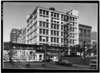
.jpg)


_-_correct_version.jpg)


.jpg)


.jpg)

.jpg)


.gif)
_Building.jpg)


.jpg)