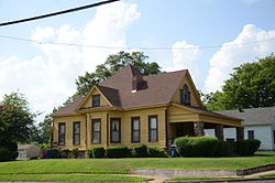
Paul Laurence Dunbar School Neighborhood Historic District

Paul Laurence Dunbar School Neighborhood Historic District | |
 | |
Location in Arkansas | |
| Location | Roughly bounded by Wright Ave., S. Chester, S. Ringo & W. 24th Sts., Little Rock, Arkansas |
|---|---|
| Coordinates | 34°43′44″N 92°17′7″W / 34.72889°N 92.28528°W |
| NRHP reference No. | 13000789 |
| Added to NRHP | September 27, 2013[1] |
The Paul Laurence Dunbar School Neighborhood Historic District encompasses a historical neighborhood area of central Little Rock, Arkansas. Primarily developed between 1890 and 1915, the area was initially racially integrated, but had by the mid-1960s become predominantly African-American. It is anchored at the northern end by the Dunbar School campus, and extends south for 6-1/2 blocks along South Cross and South Ringo Streets. Prominent houses in the district include the Miller House (1853 S. Ringo), the Womack House (1867 S. Ringo), and the Scipio A. Jones House (1872 S. Cross).[2]
The district was listed on the National Register of Historic Places in 2013.[1]
See also
[edit]References
[edit]- ^ a b "National Register Information System". National Register of Historic Places. National Park Service. April 15, 2008.
- ^ "NRHP nomination for Paul Laurence Dunbar School Neighborhood Historic District". Arkansas Preservation. Retrieved November 14, 2015.

