| [2] | Name[3] | Bild | Eintragsdatum | Lage | Ort | Beschreibung |
| 1 | Amherst Central Business District |  Amherst Central Business District Amherst Central Business District | 27. Dez. 1991
ID-Nr. 91001859 |
42° 22′ 38″ N, 72° 31′ 13″ W42.377222-72.520278 | Amherst | |
| 2 | Amherst West Cemetery | 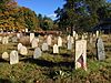 Amherst West Cemetery Amherst West Cemetery | 26. Mai 2000
ID-Nr. 00000534 | Triangle St.
42° 22′ 45″ N, 72° 31′ 7″ W42.379167-72.518611 | Amherst | |
| 3 | Baird House |  Baird House Baird House | 3. Jan. 1985
ID-Nr. 85000026 | 38 Shays St.
42° 21′ 0″ N, 72° 31′ 9″ W42.35-72.519167 | Amherst | |
| 4 | Belchertown Center Historic District |  Belchertown Center Historic District Belchertown Center Historic District | 2. Juni 1982
ID-Nr. 82001913 |
42° 16′ 37″ N, 72° 24′ 6″ W42.276944-72.401667 | Belchertown | |
| 5 | Belchertown State School |  Belchertown State School Belchertown State School | 19. Juli 1994
ID-Nr. 94000688 | 30 State St.
42° 16′ 28″ N, 72° 25′ 27″ W42.274444-72.424167 | Belchertown | |
| 6 | Bisbee Mill |  Bisbee Mill Bisbee Mill | 31. März 2005
ID-Nr. 05000219 | 66 East St.
42° 22′ 36″ N, 72° 49′ 9″ W42.376667-72.819167 | Chesterfield | |
| 7 | Bradstreet Historic District |  Bradstreet Historic District Bradstreet Historic District | 17. Juli 1997
ID-Nr. 97000724 |
42° 24′ 19″ N, 72° 35′ 26″ W42.405278-72.590556 | Hatfield | |
| 8 | William Cullen Bryant Homestead | 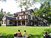 William Cullen Bryant Homestead William Cullen Bryant Homestead
weitere Bilder | 15. Okt. 1966
ID-Nr. 66000136 |
42° 28′ 19″ N, 72° 56′ 9″ W42.471944-72.935833 | Cummington | |
| 9 | Building at 8-22 Graves Avenue |  Building at 8-22 Graves Avenue Building at 8-22 Graves Avenue | 7. Nov. 1985
ID-Nr. 85002784 | 8-22 Graves Ave.
42° 19′ 19″ N, 72° 37′ 44″ W42.321944-72.628889 | Northampton | |
| 10 | Center Cemetery | 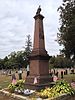 Center Cemetery Center Cemetery | 16. Apr. 2013
ID-Nr. 13000170 | 178 College Hwy. (Route 10)
42° 14′ 5,5″ N, 72° 43′ 37,3″ W42.234869-72.727031 | Southampton | |
| 11 | Center Cemetery |  Center Cemetery Center Cemetery | 26. Feb. 2004
ID-Nr. 04000084 | Sam Hill Rd.
42° 23′ 40″ N, 72° 56′ 36″ W42.394444-72.943333 | Worthington | |
| 12 | Chesterfield Center Historic District |  Chesterfield Center Historic District Chesterfield Center Historic District | 11. Dez. 2008
ID-Nr. 08001177 | Main Rd., South St., North Rd., Bagg Rd., Bryant St.
42° 23′ 30″ N, 72° 50′ 27″ W42.391667-72.840833 | Chesterfield | |
| 13 | Church Street Historic District | 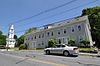 Church Street Historic District Church Street Historic District | 23. Mai 1986
ID-Nr. 86001246 |
42° 15′ 57″ N, 72° 13′ 53″ W42.265833-72.231389 | Ware | |
| 14 | Clarke School for the Deaf Historic District | | 2. Mai 2022
ID-Nr. 100007664 |
42° 20′ 17,5″ N, 72° 37′ 50,2″ W42.3382-72.6306 | Northampton | |
| 15 | Conkey-Stevens House |  Conkey-Stevens House Conkey-Stevens House | 10. Mai 1979
ID-Nr. 79000352 | 664 Main St.
42° 22′ 33″ N, 72° 30′ 20″ W42.375833-72.505556 | Amherst | |
| 16 | Calvin Coolidge House |  Calvin Coolidge House Calvin Coolidge House | 12. Dez. 1976
ID-Nr. 76000262 | 19-21 Massasoit St.
42° 19′ 29″ N, 72° 38′ 49″ W42.324722-72.646944 | Northampton | |
| 17 | Cushman Village Historic District |  Cushman Village Historic District Cushman Village Historic District | 5. Nov. 1992
ID-Nr. 92001553 |
42° 25′ 3″ N, 72° 30′ 26″ W42.4175-72.507222 | Amherst | |
| 18 | Dickinson Historic District |  Dickinson Historic District Dickinson Historic District | 16. Aug. 1977
ID-Nr. 77000182 | Kellogg Ave., Main, Gray, und Lessey Sts.
42° 22′ 35″ N, 72° 30′ 55″ W42.376389-72.515278 | Amherst | |
| 19 | Emily Dickinson House | 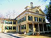 Emily Dickinson House Emily Dickinson House
weitere Bilder | 15. Okt. 1966
ID-Nr. 66000363 | 280 Main St.
42° 22′ 33″ N, 72° 30′ 52″ W42.375833-72.514444 | Amherst | |
| 20 | Dorsey-Jones House | 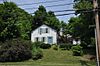 Dorsey-Jones House Dorsey-Jones House | 2. Sep. 2005
ID-Nr. 05000931 | 191 Nonotuck St.
42° 19′ 52″ N, 72° 40′ 18″ W42.331111-72.671667 | Northampton | Standort der Underground Railroad. |
| 21 | East Village Historic District |  East Village Historic District East Village Historic District | 6. Juli 1986
ID-Nr. 86001408 | Main, N. und S. East Sts.
42° 22′ 36″ N, 72° 30′ 4″ W42.376667-72.501111 | Amherst | |
| 22 | Elm Street Historic District |  Elm Street Historic District Elm Street Historic District | 7. Dez. 2000
ID-Nr. 00001481 | Elm, Sunset, und Scotland Sts., Little Neponset Rd.
42° 21′ 35″ N, 72° 37′ 0″ W42.359722-72.616667 | Hatfield | |
| 23 | First Congregational Church | | 3. März 2020
ID-Nr. 100003963 | 1 Church St.
42° 15′ 30,8″ N, 72° 34′ 37,1″ W42.2585684-72.5769701 | South Hadley | |
| 24 | Fort Hill Historic District |  Fort Hill Historic District Fort Hill Historic District | 7. Apr. 1989
ID-Nr. 88000910 |
42° 18′ 43″ N, 72° 38′ 1″ W42.311944-72.633611 | Northampton | |
| 25 | Forty Acres and Its Skirts Historic District |  Forty Acres and Its Skirts Historic District Forty Acres and Its Skirts Historic District | 4. Mai 2023
ID-Nr. 100008956 | 130 113-115 123 River Dr.
42° 22′ 8″ N, 72° 35′ 7″ W42.368889-72.585278 | Hadley | |
| 26 | Gate Cemetery |  Gate Cemetery Gate Cemetery | 1. Juli 2009
ID-Nr. 09000470 | Ireland Street
42° 23′ 33,5″ N, 72° 53′ 2″ W42.392639-72.883889 | Chesterfield | |
| 27 | Goodwin Memorial African Methodist Episcopal Zion Church |  Goodwin Memorial African Methodist Episcopal Zion Church Goodwin Memorial African Methodist Episcopal Zion Church | 28. Apr. 2000
ID-Nr. 00000416 | Woodside Ave.
42° 22′ 15″ N, 72° 31′ 23″ W42.370833-72.523056 | Amherst | |
| 28 | Goshen Town Hall |  Goshen Town Hall Goshen Town Hall | 28. Aug. 2018
ID-Nr. 100002829 | 42 Main St.
42° 26′ 29,4″ N, 72° 48′ 7,2″ W42.4415001-72.8019904 | Goshen | |
| 29 | Grove Hill Mansion |  Grove Hill Mansion Grove Hill Mansion
weitere Bilder | 11. Aug. 1982
ID-Nr. 82001910 | Florence Rd. und Front St.
42° 21′ 11″ N, 72° 41′ 58″ W42.353056-72.699444 | Northampton | |
| 30 | Hadley Center Historic District |  Hadley Center Historic District Hadley Center Historic District | 2. Dez. 1977
ID-Nr. 77000185 | Middle und Russell Sts.
42° 20′ 28″ N, 72° 35′ 22″ W42.341111-72.589444 | Hadley | |
| 31 | Hatfield Center Historic District |  Hatfield Center Historic District Hatfield Center Historic District | 27. Juli 1994
ID-Nr. 94000737 |
42° 21′ 43″ N, 72° 36′ 1″ W42.361944-72.600278 | Hatfield | |
| 32 | Haydenville Historic District |  Haydenville Historic District Haydenville Historic District | 26. März 1976
ID-Nr. 76000273 | Main und High Sts. und Kingsley Ave.
42° 22′ 31″ N, 72° 42′ 9″ W42.375278-72.7025 | Williamsburg | |
| 33 | Hockanum Rural Historic District |  Hockanum Rural Historic District Hockanum Rural Historic District | 30. Dez. 1993
ID-Nr. 93001474 |
42° 17′ 52″ N, 72° 35′ 53″ W42.297778-72.598056 | Hadley | |
| 34 | Huntington Village Historic District |  Huntington Village Historic District Huntington Village Historic District | 15. Sep. 1999
ID-Nr. 99001080 |
42° 14′ 7″ N, 72° 52′ 54″ W42.235278-72.881667 | Huntington | |
| 35 | Ireland Street Cemetery |  Ireland Street Cemetery Ireland Street Cemetery | 1. Juli 2009
ID-Nr. 09000471 | Ireland Street
42° 21′ 54″ N, 72° 53′ 3″ W42.365-72.884167 | Chesterfield | |
| 36 | Lincoln-Sunset Historic District |  Lincoln-Sunset Historic District Lincoln-Sunset Historic District | 22. Feb. 1993
ID-Nr. 93000008 |
42° 22′ 33″ N, 72° 31′ 33″ W42.375833-72.525833 | Amherst | |
| 37 | Lockville Historic District |  Lockville Historic District Lockville Historic District | 24. Jan. 2001
ID-Nr. 00001657 | College Hwy.
42° 12′ 42″ N, 72° 43′ 52″ W42.211667-72.731111 | Southampton | |
| 38 | Main Street Historic District |  Main Street Historic District Main Street Historic District | 17. März 1986
ID-Nr. 86000451 |
42° 16′ 11″ N, 72° 40′ 22″ W42.269722-72.672778 | Easthampton | |
| 39 | The Manse |  The Manse The Manse | 14. Okt. 1976
ID-Nr. 76000263 | 54 Prospect St.
42° 19′ 20″ N, 72° 38′ 12″ W42.322222-72.636667 | Northampton | |
| 40 | Middlefield-Becket Stone Arch Railroad Bridge District |  Middlefield-Becket Stone Arch Railroad Bridge District Middlefield-Becket Stone Arch Railroad Bridge District
weitere Bilder | 11. Apr. 1980
ID-Nr. 80000502 |
42° 18′ 44″ N, 73° 1′ 10″ W42.312222-73.019444 | Middlefield | |
| 41 | Middlefield Center Historic District |  Middlefield Center Historic District Middlefield Center Historic District | 3. Okt. 2012
ID-Nr. 12000827 | 138-188 Skyline Trail, & 7 Bell Rd.
42° 20′ 55,4″ N, 73° 0′ 55,4″ W42.348712-73.015394 | Middlefield | |
| 42 | Mill-Prospect Street Historic District |  Mill-Prospect Street Historic District Mill-Prospect Street Historic District | 22. Okt. 2002
ID-Nr. 02001188 | Prospect, Chestnut, Bridge, School Sts., Raymond Ave., Prospect Court
42° 22′ 31″ N, 72° 36′ 47″ W42.375278-72.613056 | Hatfield | |
| 43 | Miss Florence Diner |  Miss Florence Diner Miss Florence Diner | 22. Sep. 1999
ID-Nr. 99001123 | 99 Main St.
42° 20′ 7″ N, 72° 40′ 18″ W42.335278-72.671667 | Northampton | |
| 44 | Mountain Rest |  Mountain Rest Mountain Rest | 10. Nov. 1983
ID-Nr. 83003984 |
42° 27′ 36″ N, 72° 50′ 23″ W42.46-72.839722 | Goshen | |
| 45 | Nashawannuck Mills Historic District |  Nashawannuck Mills Historic District Nashawannuck Mills Historic District | 12. Feb. 2015
ID-Nr. 15000001 | 1-15 Cottage St.
42° 15′ 57,2″ N, 72° 40′ 2″ W42.265889-72.667231 | Easthampton | |
| 46 | North Amherst Center Historic District |  North Amherst Center Historic District North Amherst Center Historic District | 13. Dez. 1991
ID-Nr. 91001824 | 1184-1136 N. Pleasant St., 1-39 Pine St., 11-13 Meadow St.
42° 24′ 33″ N, 72° 31′ 52″ W42.409167-72.531111 | Amherst | |
| 47 | North Cemetery |  North Cemetery North Cemetery | 3. März 2004
ID-Nr. 04000121 | Cold St.
42° 25′ 22″ N, 72° 56′ 49″ W42.422778-72.946944 | Worthington | |
| 48 | North Hadley Historic District |  North Hadley Historic District North Hadley Historic District | 30. Dez. 1993
ID-Nr. 93001475 |
42° 23′ 23″ N, 72° 34′ 50″ W42.389722-72.580556 | Hadley | |
| 49 | North Hatfield Historic District |  North Hatfield Historic District North Hatfield Historic District | 30. Okt. 1997
ID-Nr. 97000879 |
42° 24′ 33″ N, 72° 37′ 26″ W42.409167-72.623889 | Hatfield | |
| 50 | Northampton Downtown Historic District |  Northampton Downtown Historic District Northampton Downtown Historic District | 17. Mai 1976
ID-Nr. 85001464 |
42° 19′ 5″ N, 72° 37′ 57″ W42.318056-72.6325 | Northampton | |
| 51 | Northampton State Hospital |  Northampton State Hospital Northampton State Hospital | 25. Juli 1994
ID-Nr. 94000696 | 1 Prince St.
42° 18′ 45″ N, 72° 39′ 15,8″ W42.3125-72.6544 | Northampton | In den 2000er Jahren größtenteils abgerissen. |
| 52 | Northampton Veterans Administration Hospital Historic District |  Northampton Veterans Administration Hospital Historic District Northampton Veterans Administration Hospital Historic District | 4. Dez. 2012
ID-Nr. 12000994 | 421 N. Main St.
42° 20′ 59,1″ N, 72° 40′ 53,9″ W42.34976-72.68163 | Northampton | |
| 53 | Old Chapel |  Old Chapel Old Chapel | 11. Mai 2015
ID-Nr. 15000211 | 144 Hicks Way
42° 23′ 20,4″ N, 72° 31′ 40,8″ W42.389-72.528 | Amherst | Eines der ältesten Gebäude auf dem Campus der University of Massachusetts Amherst. |
| 54 | Old Mill Site Historic District | 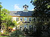 Old Mill Site Historic District Old Mill Site Historic District | 2. Juni 1982
ID-Nr. 82001911 | 48 und 50 Prospect St.
42° 22′ 16″ N, 72° 35′ 49″ W42.371111-72.596944 | Hatfield | |
| 55 | Otis Company Mill No. 1 |  Otis Company Mill No. 1 Otis Company Mill No. 1 | 2. Mai 1982
ID-Nr. 82001909 | E. Main St.
42° 15′ 31″ N, 72° 14′ 20″ W42.258611-72.238889 | Ware | |
| 56 | Parsons, Shepherd, und Damon Houses Historic District | 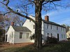 Parsons, Shepherd, und Damon Houses Historic District Parsons, Shepherd, und Damon Houses Historic District | 6. Juni 2001
ID-Nr. 01000627 | 46, 58 und 66 Bridge St.
42° 19′ 20″ N, 72° 37′ 35″ W42.322222-72.626389 | Northampton | |
| 57 | Pelham Town Hall Historic District | 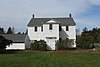 Pelham Town Hall Historic District Pelham Town Hall Historic District | 23. Nov. 1971
ID-Nr. 71000085 | Amherst Rd. at the corner of Daniel Shays Hwy.
42° 23′ 32″ N, 72° 24′ 16″ W42.392222-72.404444 | Pelham | |
| 58 | Plainfield Center Historic District | 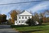 Plainfield Center Historic District Plainfield Center Historic District | 27. Juli 2015
ID-Nr. 15000468 |
42° 30′ 58,3″ N, 72° 54′ 47,9″ W42.5162-72.9133 | Plainfield | |
| 59 | Pomeroy Terrace Historic District |  Pomeroy Terrace Historic District Pomeroy Terrace Historic District | 11. Mai 2018
ID-Nr. 100002420 |
42° 19′ 16,3″ N, 72° 37′ 34,6″ W42.3211885-72.6262834 | Northampton | |
| 60 | Porter-Phelps-Huntington House |  Porter-Phelps-Huntington House Porter-Phelps-Huntington House | 26. März 1973
ID-Nr. 73000303 | 130 River Dr.
42° 22′ 19″ N, 72° 35′ 24″ W42.371944-72.59 | Hadley | |
| 61 | Prospect-Gaylord Historic District |  Prospect-Gaylord Historic District Prospect-Gaylord Historic District | 4. Feb. 1993
ID-Nr. 93000007 |
42° 22′ 33″ N, 72° 31′ 22″ W42.375833-72.522778 | Amherst | |
| 62 | Ringville Cemetery | 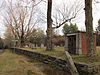 Ringville Cemetery Ringville Cemetery | 11. Feb. 2004
ID-Nr. 04000024 | Witt Hill Rd.
42° 22′ 13″ N, 72° 54′ 56″ W42.370278-72.915556 | Worthington | |
| 63 | Ross Farm | 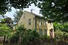 Ross Farm Ross Farm | 8. Jan. 2008
ID-Nr. 07001360 | 123 Meadow St.
42° 20′ 2″ N, 72° 40′ 49″ W42.333889-72.680278 | Northampton | Standort der Underground Railroad |
| 64 | Smith Alumnae Gymnasium |  Smith Alumnae Gymnasium Smith Alumnae Gymnasium | 30. Apr. 1976
ID-Nr. 76000259 | Smith College campus Green St.
42° 19′ 1″ N, 72° 38′ 18″ W42.316944-72.638333 | Northampton | |
| 65 | South Amherst Common Historic District | 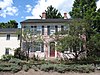 South Amherst Common Historic District South Amherst Common Historic District | 17. Feb. 1995
ID-Nr. 95000100 |
42° 20′ 29″ N, 72° 30′ 18″ W42.341389-72.505 | Amherst | |
| 66 | South Hadley Canal Historic District |  South Hadley Canal Historic District South Hadley Canal Historic District | 11. März 1992
ID-Nr. 92000077 |
42° 13′ 14,9″ N, 72° 36′ 33,1″ W42.2208-72.6092 | South Hadley | |
| 67 | South Worthington Historic District |  South Worthington Historic District South Worthington Historic District | 1. Sep. 2005
ID-Nr. 05000935 |
42° 20′ 47″ N, 72° 53′ 36″ W42.346389-72.893333 | Worthington und Chesterfield | |
| 68 | Southampton Center Historic District |  Southampton Center Historic District Southampton Center Historic District | 4. Apr. 1991
ID-Nr. 91000363 |
42° 13′ 25″ N, 72° 43′ 55″ W42.223611-72.731944 | Southampton | |
| 69 | Strong House | 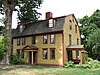 Strong House Strong House | 5. Juli 1984
ID-Nr. 84002457 | 67 Amity St.
42° 22′ 33″ N, 72° 31′ 19″ W42.375833-72.521944 | Amherst | |
| 70 | The Town Farm |  The Town Farm The Town Farm | 12. Sep. 1996
ID-Nr. 96000950 | 75 Oliver St.
42° 16′ 50″ N, 72° 41′ 51″ W42.280556-72.6975 | Easthampton | |
| 71 | Upper Main Street Historic District |  Upper Main Street Historic District Upper Main Street Historic District | 22. Juli 1994
ID-Nr. 94000735 |
42° 23′ 15″ N, 72° 35′ 52″ W42.3875-72.597778 | Hatfield | |
| 72 | US Post Office-Easthampton Main |  US Post Office-Easthampton Main US Post Office-Easthampton Main | 1. Apr. 1986
ID-Nr. 86000714 | 19 Union St.
42° 16′ 10″ N, 72° 40′ 19″ W42.269444-72.671944 | Easthampton | |
| 73 | US Post Office-South Hadley Main |  US Post Office-South Hadley Main US Post Office-South Hadley Main | 28. Mai 1986
ID-Nr. 86001188 | 1 Hadley St.
42° 15′ 30″ N, 72° 34′ 31″ W42.258333-72.575278 | South Hadley | |
| 74 | Walker-Collis House |  Walker-Collis House Walker-Collis House | 30. Sep. 1982
ID-Nr. 82001903 | 1 Stadler St.
42° 16′ 21″ N, 72° 24′ 38″ W42.2725-72.410556 | Belchertown | |
| 75 | Ware Center Historic District |  Ware Center Historic District Ware Center Historic District | 8. Mai 1986
ID-Nr. 86001013 | MA 9 und Greenwich Plains Rd.
42° 15′ 40″ N, 72° 16′ 42″ W42.261111-72.278333 | Ware | |
| 76 | Ware Millyard Historic District |  Ware Millyard Historic District Ware Millyard Historic District | 21. Nov. 1986
ID-Nr. 86003508 |
42° 15′ 33″ N, 72° 14′ 17″ W42.259167-72.238056 | Ware | |
| 77 | Ware Town Hall |  Ware Town Hall Ware Town Hall | 26. Juni 1986
ID-Nr. 86001403 | Main und West Sts.
42° 15′ 36″ N, 72° 14′ 35″ W42.26-72.243056 | Ware | |
| 78 | Ware-Hardwick Covered Bridge |  Ware-Hardwick Covered Bridge Ware-Hardwick Covered Bridge | 8. Mai 1986
ID-Nr. 86001006 | Old Gilbertville Rd. und Bridge St.
42° 18′ 37″ N, 72° 12′ 45″ W42.310278-72.2125 | Ware | |
| 79 | West Chesterfield Historic District |  West Chesterfield Historic District West Chesterfield Historic District
weitere Bilder | 25. Sep. 2008
ID-Nr. 08000950 |
42° 24′ 12″ N, 72° 52′ 37″ W42.403333-72.876944 | Chesterfield | |
| 80 | West Hatfield Historic District |  West Hatfield Historic District West Hatfield Historic District | 24. Feb. 2005
ID-Nr. 05000079 | 3-12 Church Ave., 2 Linseed Rd., 23-42 West St.
42° 22′ 19″ N, 72° 38′ 12″ W42.371944-72.636667 | Hatfield | |
| 81 | Westside Historic District |  Westside Historic District Westside Historic District | 25. Juli 2000
ID-Nr. 00000793 | Baker und Snell Sts., Northampton Rd., und Hazel Ave.
42° 22′ 0″ N, 72° 31′ 51″ W42.366667-72.530833 | Amherst | |
| 82 | Williamsburg Center Historic District |  Williamsburg Center Historic District Williamsburg Center Historic District | 22. Juni 1980
ID-Nr. 80000506 | MA 9
42° 23′ 32″ N, 72° 43′ 49″ W42.392222-72.730278 | Williamsburg | |
| 83 | Woodbridge Street Historic District |  Woodbridge Street Historic District Woodbridge Street Historic District | 14. Nov. 1983
ID-Nr. 83003987 | 3 und 7 Silver St., 25-82 Woodbridge St.
42° 15′ 52″ N, 72° 34′ 21″ W42.264444-72.5725 | South Hadley | |
 Van Wikipedia, de gratis encyclopedie


_map.jpg)


