Azov Upland
 From Wikipedia the free encyclopedia

This article includes a list of references, related reading, or external links, but its sources remain unclear because it lacks inline citations. (December 2023) |
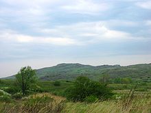
Azov Upland is a plateau or range of hills in East Ukraine within the Donetsk and Zaporizhia oblasts.
To the north it borders Dnieper Lowland, to northeast – Donets Ridge, southwest – Black Sea Lowland, south – Azov Lowland. Elevation varies between 200–250 m (660–820 ft).
Interesting features are mounds locally known as mohyly similar to Russian equivalent of kurgan. The highest hill is Belmak-Mohyla (Horyla) that rises at 327 m (1,073 ft).
The climate is similar to Donets Ridge. Soils are categorized as chernozem of poor or medium humus. Vegetation is a fescue-feather-grass steppe.
References
[edit]External links
[edit]- Azov Upland at the Encyclopedia of Ukraine
- Azov Upland at the Encyclopædia Britannica
- Azov Upland at the Great Soviet Encyclopedia
47°19′53″N 36°34′45″E / 47.3315°N 36.5791°E