Boulevard Adolphe Max
 From Wikipedia the free encyclopedia
 Narrow, triangle-shaped building on the Boulevard Adolphe Max/Adolphe Maxlaan | |
 Location within Brussels  Boulevard Adolphe Max (Belgium) | |
| Location | City of Brussels, Brussels-Capital Region, Belgium |
|---|---|
| Quarter | Marais–Jacqmain Quarter |
| Coordinates | 50°51′13″N 04°21′20″E / 50.85361°N 4.35556°E |
| Construction | |
| Completion | 1868–1871 |
| Other | |
| Designer | Léon Suys |
The Boulevard Adolphe Max (French: [bul.vaʁ a.dɔlf maks]) or Adolphe Maxlaan (Dutch) is a central boulevard in Brussels, Belgium. It was created following the covering of the river Senne (1867–1871), and bears the name of Adolphe Max, a former mayor of the City of Brussels.
The Boulevard Adolphe Max is located between the Place de Brouckère/De Brouckèreplein and the Place Charles Rogier/Karel Rogierplein, in the extension of the Boulevard Anspach/Anspachlaan. It runs parallel to Brussels' busiest shopping street, the Rue Neuve/Nieuwstraat. It is served by the metro and premetro (underground tram) stations De Brouckère (on lines 1, 3, 4 and 5) and Rogier (on lines 2, 3, 4 and 6).
History[edit]
The Boulevard Adolphe Max was built between 1867 and 1871, as part of the North–South Axis, which was created after the covering of the river Senne.[1][2] To stimulate the new boulevard's development, an architectural competition was organised. The first prize was awarded in 1876 to the Maison des Chats or Hier is't in den kater en de kat (loosely, "House of Cats") by the architect Henri Beyaert.[3] The boulevard was originally named the Boulevard du Nord/Noordlaan ("North Boulevard"), since it led to the old North Station on the Place Charles Rogier.[4] In 1919, it was renamed in honour of the then-mayor of the City of Brussels, Adolphe Max (1869–1939).[4]

Until the Second World War, the Boulevard Adolphe Max was one of the liveliest streets in Brussels, with renowned shops, typical Brussels cafés and an impressive number of cinemas. On 4 September 1944, it was the scene of great jubilation during the liberation of Brussels by the British Guards Armoured Division. From the 1970s, however, the area entered a period of urban decay. Almost all the old shops disappeared, and in their place, souvenir shops, snack bars and sex shops opened. The luxurious Hotel Le Plaza, located on the boulevard, also closed its doors in 1976. Since 1976, the North–South line of the Brussels premetro has run underneath the boulevard. The reopening of the Hotel Le Plaza in 1998 marked the beginning of a certain revival. By the turn of the 21st century, only a few sex cinemas remained. The last one, the ABC, closed in 2014.
In recent years, the introduction of one-way traffic on the side near the Place de Brouckère has reduced the traffic volume considerably. There are also currently plans to renovate the Boulevard Adolphe Max and its surrounding streets, as part of the broader revitalisation of the city centre.[5]
Notable buildings[edit]
The Boulevard Adolphe Max is home to many buildings in neoclassical, Beaux-Arts, Art Nouveau, Art Deco and eclectic styles. Some examples include:
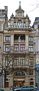
- No. 1–3: Maison des Chats or Hier ist in den kater en de kat (1874), an eclectic building of neo-Flemish Renaissance inspiration, by Henri Beyaert[3]
- No. 5–9: Hotel Atlanta (1925–1929), an Art Deco hotel by Michel Polak[6]
- No. 11–17: Thonet House (1872), an eclectic apartment building by Félix Laureys[7]
- No. 104: Marivaux theatre, original neoclassical building (1873) by D.G. Marinus, Art Deco redesign (1923) by G. Hubrecht[8]
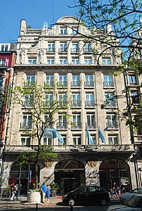
- No. 118–126: Hotel Le Plaza (1928), an Art Deco hotel and cinema, by Alfred Hoch and Michel Polak[9]
-
-
 Hotel Atlanta (Polak, 1925–1929)
 -
 Thonet House (Laureys, 1872)
 -
 Marivaux theatre (Marinus, 1873 and Hubrecht, 1923)
 -
 Hotel le Plaza (Hoch and Polak, 1928)


See also[edit]
- List of streets in Brussels
- Neoclassical architecture in Belgium
- Art Nouveau in Brussels
- Art Deco in Brussels
- History of Brussels
- Belgium in the long nineteenth century
References[edit]
Citations[edit]
- ^ Demey 1990, p. 65.
- ^ Map of Suys' proposal. City Archives of Brussels: p.p. 1.169
- ^ a b "Bruxelles Pentagone - Hier is\'t in den Kater en de Kat - Boulevard Adolphe Max 1-3 - BEYAERT Henri". www.irismonument.be. Retrieved 16 December 2018.
- ^ a b Eggericx 1997, p. 5.
- ^ "Preliminary design for the reconstruction of the Boulevard Adolphe Max and surroundings". www.brussels.be. Retrieved 16 December 2018.
- ^ "Hôtel Atlanta – Inventaire du patrimoine architectural". monument.heritage.brussels (in French). Retrieved 26 January 2021.
- ^ "Bruxelles Pentagone - Boulevard Adolphe Max 11-13-15-17 - LAUREYS F." www.irismonument.be. Retrieved 16 December 2018.
- ^ "Bruxelles Pentagone - Theatre Marivaux (1922) / Marivaux (1967) - Boulevard Adolphe Max 104-106 - Rue Saint-Pierre 17-19-21-23-25 - MARINUS D.G." www.irismonument.be. Retrieved 16 December 2018.
- ^ "Bruxelles Pentagone - Hotel Plaza - Boulevard Adolphe Max 118-126 - Rue de Malines 29-31 - Rue Saint-Pierre 37-39 - HOCH Alfred". www.irismonument.be. Retrieved 16 December 2018.
Bibliography[edit]
- Demey, Thierry (1990). Bruxelles, chronique d'une capitale en chantier (in French). Vol. I: Du voûtement de la Senne à la jonction Nord-Midi. Brussels: Paul Legrain/CFC. OCLC 44643865.
- Demey, Thierry (2013). Bruxelles, des remparts aux boulevards (in French). Brussels: Badeaux. ISBN 978-2-930609-02-7.
- Eggericx, Laure (1997). Les Boulevards du Centre. Bruxelles, ville d'Art et d'Histoire (in French). Vol. 20. Brussels: Centre d'information, de Documentation et d'Etude du Patrimoine.
- Le Patrimoine monumental de la Belgique: Bruxelles (PDF) (in French). Vol. 1B: Pentagone E-M. Liège: Pierre Mardaga. 1993.
External links[edit]
 Media related to Boulevard Adolphe Max/Adolphe Maxlaan, Brussels at Wikimedia Commons