Carn Llidi
 From Wikipedia the free encyclopedia
| Carn Llidi | |
|---|---|
.jpg) | |
| Highest point | |
| Elevation | 181 m (594 ft)[1] |
| Prominence | 122 m (400 ft)[1] |
| Listing | HuMP |
| Coordinates | 51°54′16″N 5°17′23″W / 51.90456°N 5.28967°W |
| Naming | |
| English translation | Cairn of the Ashes |
| Language of name | Welsh |
| Geography | |
 Carn Llidi | |
| OS grid | SM738280 |
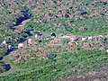
Carn Llidi is a hill east of St David's Head in Pembrokeshire, Wales. Carn Llidi and its surrounding area is part of the Pembrokeshire Coast National Park.[2]
The 594 feet (181 m) rocky hill stands in a prominent and isolated position dominating Whitesands Bay. On clear days, there are views west towards Ramsey Island and the Bishops and Clerks islets, and north towards Strumble Head; on clear evenings, in mid-summer at sunset, glimpses of the Wicklow Mountains in Ireland.[2][3]
Archaeology[edit]
The area is rich in archaeology. Two burial chambers, presumed to be neolithic, are located on the higher southwest slopes of the hill.[4] Another stone nearby may be the capstone of a megalithic chamber.[5] Prehistoric enclosures and field systems are located to the northwest of the hill,[6] near to an iron-age defensive wall.[7]
During World War II, a Chain Home Low early-warning radar station was located on Carn Llidi. The concrete base and a Lewis gun pit remain.[8]
Also during World War II, on 4 June 1943, a Martin B-26 Marauder medium bomber of the 335th Bombardment Group of the US Air Force crashed into Carn Llidi killing all four crew, after it had become lost in poor weather on a flight from North Africa to Cornwall. A memorial incorporating one of the twisted propeller blades is located in the Whitesands Bay car park.[9]
Name[edit]
The meaning of Carn Llidi is Cairn of the Ashes, llidi being a South Walian variant of lludw, meaning ash or ashes.[10]
Access to the summit[edit]
The walk which leads from a Whitesands Bay car park can take you to the summit either through Porthmawr Farm or via the coast path towards St Davids Head. The climb does not require any special hiking ability, but it is advisable to wear proper outdoor clothing.[11]
-
![Carn Llidi from Whitesands Bay]](//upload.wikimedia.org/wikipedia/commons/thumb/e/e5/Carn_Llidi_from_Whitesands_Bay.png/120px-Carn_Llidi_from_Whitesands_Bay.png) Carn Llidi from Whitesands Bay]
Carn Llidi from Whitesands Bay] -
 Welsh mountain ponies near the summit
 -
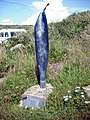 Memorial to the 1943 USAF plane crash


See also[edit]
References[edit]
- ^ a b "Carn Llidi". Hill Bagging. Retrieved 3 February 2017.[self-published source]
- ^ a b "Places to visit on the St Davids Peninsula". Pembrokeshire Coast National Park. Retrieved 3 February 2017.
- ^ Dennis Kelsall, Jan Kelsall (2012). Walking in Pembrokeshire: 41 circular walks in the national park. Cicerone Press. p. 69. ISBN 9781849655194. Retrieved 5 February 2017.
- ^ "Carn Llidi, Burial Chambers (305392)". Coflein. RCAHMW. Retrieved 3 February 2017.
- ^ "Carn Llidi, Stone S of (400282)". Coflein. RCAHMW. Retrieved 3 February 2017.
- ^ "Carn Llidi Enclosures; Penmaen Dewi Field System, St David's Head (24364)". Coflein. RCAHMW. Retrieved 3 February 2017.
- ^ "Carn Llidi Defensive Wall (418496)". Coflein. RCAHMW. Retrieved 3 February 2017.
- ^ "St David's Head". Experience Pembrokeshire. Archived from the original on 4 February 2017. Retrieved 3 February 2017.
- ^ "Daughters remember US crash crew". BBC News. 6 June 2005.
- ^ Charles, B.G. (1992). The Place Names of Pembrokeshire. National Library of Wales. p. sv Cnwc y Lludw. ISBN 0907158587.
- ^ Jacinta Ashworth. "Walk 2057 - St. David's Head & Carn Llidi". www.walkingbritain.co.uk. Retrieved 3 February 2017.