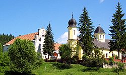
Gomirje
 From Wikipedia the free encyclopedia
Gomirje | |
|---|---|
Village | |
 | |
| Coordinates: 45°20′10″N 15°07′01″E / 45.33611°N 15.11694°E | |
| Country | |
| County | Primorje-Gorski Kotar |
| Municipality | Vrbovsko |
| Area | |
• Total | 6.7 km2 (2.6 sq mi) |
| Population (2021)[3] | |
• Total | 255 |
| • Density | 38/km2 (99/sq mi) |
| Time zone | UTC+1 (CET) |
| • Summer (DST) | UTC+2 (CEST) |
Gomirje is a settlement in north-western Croatia, situated at the far east of the mountainous region of Gorski kotar in the Primorje-Gorski Kotar County. It is part of the Vrbovsko municipality. The population is 343 (as of the 2011 census). [4][5]
Demographics
[edit]
Sights
[edit]- Gomirje Monastery - the westernmost Orthodox monastery
Notable natives and residents
[edit]- Lazar Mamula (1795-1878) - baron, general in the general in Austro-Hungarian army and governor of Dalmatia
- Bogdan Mamula (1918-2002) - antifascist, partisan and People's Hero of Yugoslavia
- Desanka Đorđević (1927-2011) - dancer and folk dance choreographer in the National Ensemble of Folk Dances and Songs of Serbia, Ensemble "Kolo"
References
[edit]- ^ Government of Croatia (October 2013). "Peto izvješće Republike Hrvatske o primjeni Europske povelje o regionalnim ili manjinskim jezicima" (PDF) (in Croatian). Council of Europe. p. 36. Retrieved 30 November 2016.
- ^ Register of spatial units of the State Geodetic Administration of the Republic of Croatia. Wikidata Q119585703.
- ^ "Population by Age and Sex, by Settlements" (xlsx). Census of Population, Households and Dwellings in 2021. Zagreb: Croatian Bureau of Statistics. 2022.
- ^ a b "Population by Age and Sex, by Settlements, 2011 Census: Gomirje". Census of Population, Households and Dwellings 2011. Zagreb: Croatian Bureau of Statistics. December 2012.
- ^ "The Gomirje Chronicle - Gomirje history".
- ^ "Naselja i stanovništvo Republike Hrvatske 1857-2001, www.dzs.hr". Archived from the original on 2013-11-13. Retrieved 2018-07-24.
- ^ "Anđelka Mamula: Goranski suživot i sloga / Anđelka Mamula: Co-existence and Harmony of Gorani". portalnovosti.com (in Croatian). 12 April 2018. Retrieved 24 July 2018.

