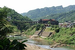
Houtong Coal Mine Ecological Park
 From Wikipedia the free encyclopedia
| Houtong Coal Mine Ecological Park | |
|---|---|
| 猴硐煤礦博物園區 | |
 | |
 | |
| Type | former coal mine |
| Location | Ruifang, New Taipei, Taiwan |
| Coordinates | 25°05′12.3″N 121°49′40.3″E / 25.086750°N 121.827861°E |
| Public transit access | Houtong Station |
The Houtong Coal Mine Ecological Park (traditional Chinese: 猴硐煤礦博物園區; simplified Chinese: 猴硐煤矿博物园区; pinyin: Hóudòng Méikuàng Bówù Yuánqū) is a former coal mine in Ruifang District, New Taipei, Taiwan.
History[edit]
The park used to be a coal mine in the region.[1] The mine began operating in 1930 and was taken over by the Ruisan Mining Company in 1934. The mine closed in 1990. Both men and women worked at the mine until 1963.[2]
Mine[edit]
The mine workings are 6 kilometers long and up to a half kilometer deep. The mine contains 300km of narrow gauge railway track. Due to its size and length of operation more coal was extracted from the Ruisan mine than any other mine in Taiwan. Due to the high temperatures underground the miners often wore little or no clothing.[2]
Architecture[edit]

The park consists of various buildings built during the Japanese rule and coal-related structures, such as coal transportation bridge, coal preparation plant, historical trail etc.[3][4]
Transportation[edit]
The park is accessible within walking distance from Houtong Station of Taiwan Railways.[5]
See also[edit]
References[edit]
- ^ "Houtong Coal Mine Ecological Park". Taiwan Medical Travel. January 2014. Retrieved 5 May 2021.
- ^ a b Cottenie, Tyler (28 April 2023). "Travel: Houtong's coal miners tell their story". Taipei Times. Retrieved 29 April 2023.
- ^ "Houtong Coal Mine Ecological Park". New Taipei City Travel. Retrieved 5 May 2021.
- ^ Claire. "Houtong". TravelKing. Retrieved 12 January 2022.
- ^ "Nostalgia Houtong". Tourism and Travel Department, New Taipei City Government. September 2020. Retrieved 23 November 2022.