Langtang
 From Wikipedia the free encyclopedia


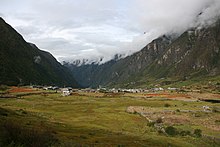
Langtang Valley (Nepali: लाङटाङ उपत्यका) also known as Lamtang Valley is a Himalayan valley in the mountains of north-central Nepal, known for its trekking routes and natural environment.
Administrative
[edit]The Langtang Valley lies in Rasuwa district of the Bagmati Province in Nepal. Situated about 80 kilometres north of the Kathmandu Valley, the valley lies within the Langtang National Park, which borders the Tibet Autonomous Region in Southwest China. Prior to the 2015 earthquake, 668 individuals were estimated to be living within the valley.[1]
Ecology
[edit]The Langtang Valley lies within the Langtang National Park. The park contains a wide variety of climatic zones, from subtropical to alpine.[2] Approximately 25% of the park is forested. Trees include the deciduous oak and maple, evergreens like pine, and various types of rhododendron. Animal life includes the Himalayan black bear, Himalayan tahr, Assam macaque, snow leopard, yak, red panda and more than 250 species of birds.[3]
Culture
[edit]Among themselves, the local inhabitants of the Langtang valley refer to each other as 'Langtangpa'. They generally follow Tibetan Buddhism, and speak a Tibetan language that is closely related to the Tibetan spoken in Kyirong, southern Tibet. The Langtangpas regard the mountain Langtang Lirung as their 'yu-lha', their local country god. However, in the state census, the Langtangpas are categorised as Tamang.[4] Langtang valley is believed to be the Beyul Dagam Namgo, one of the many hidden valleys blessed by Guru Padmasambhava.[5]
Economy
[edit]The traditional livelihoods of the Langtangpas have centered around agropastoralism.[6][7] Since the mid-1970s, tourism has grown to become an important source of livelihoods in the Langtang Valley.[8][9][10] Swiss cheese-making was introduced in Langtang in the 1950s by Werner Schulthess. Over time, Swiss cheese became a popular product of Langtang, and its production in the valley continues to this day.[11]
Access
[edit]The nearest motorable roadhead for the Langtang Valley is Syaphrubesi, which is also the base for most treks into the Langtang Valley. The distance of Syaphrubesi from Kathmandu is 80 km. But due to bad road conditions, it usually takes 6-8 hours to drive from Kathmandu to Syaphrubesi.[12] Just as for the Langtang National Park, entering the Langtang Valley requires everyone except locals to have the TIMS permit and the Langtang National Park entry permit.[13]
Tourism
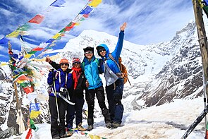
[edit]The Langtang Valley trek, from Syaphrubesi to Kyanjin Gompa and back, is known to be the third most popular trek in Nepal, after the Annapurna Circuit and Everest Base Camp (EBC) treks.[citation needed] There are several treks that go through the Langtang valley and link it to nearby valleys,[14] like the Helambu valley. In most of these treks, one can stay at local 'tea-houses', which are run by locals in nearly every village in the valley, and where one gets basic lodging and food. Around 2000, with support of the United Nations Development Programme, some of these were equipped with solar panels so that hikers could shower with warm water. There are several mountain-climbing options available too in the Langtang valley, ranging from relatively easy-to-climb peaks around 5,000 m high, such as Kyanjin Ri and Tsergo Ri, to technically challenging peaks, such as Dorje Lhakpa and Langtang Lirung.[15][16]
2015 Nepal earthquake
[edit]The village of Langtang was almost completely destroyed (1 building survived) by a massive avalanche caused by the April 2015 Nepal earthquake. The village suffered an estimated 310 deaths, including 176 Langtang residents, 80 foreigners, and 10 army personnel. More than 100 bodies were never recovered.[17] Several other villages in upper Langtang valley were also destroyed.[18] The Langtangpas who survived the destruction of the earthquake were evacuated by helicopter to Kathmandu, where a displaced persons camp was temporarily set up at the Yellow Gumba near Swayanmbhu.[19] Many Langtangpas returned to the valley in the following months, and a significant amount of reconstruction was completed within the first year after the earthquake.[20] By early 2018, the centuries-old gompa at Kyanjin Gompa, which had also been destroyed in the earthquake, had been rebuilt.[21] The Swiss-cheese factory at Kyanjin Gompa village was destroyed too, but has been rebuilt and since then become operational again.[11]
Climate change
[edit]Since the mid-2010s, Langtangpas have noticed that most natural springs in the valley have gone dry.[11] Scientists have attributed the reduction in the glacier area of the Langtang glacier directly to anthropogenic climate change since the 1970s.[22] The intergovernmental organisation ICIMOD conducts periodic cryospheric research in the Langtang valley and Yala Glacier.[23][24][25]
Langtang Himal
[edit]Langtang Himal is a mountain range in the Himalayas which includes the following peaks:[26]
| Peak | elevation |
|---|---|
| Langtang Lirung | 7,234 m (23,734 ft) |
| Langtang Ri | 7,205 m (23,638 ft) |
| Dorje Lakpa | 6,966 m (22,854 ft) |
| Loenpo Gang | 6,979 m (22,897 ft) |
| Changbu | 6,781 m (22,247 ft) |
| Yansa Tsenji | 6,690 m (21,950 ft) |
| Kyunga Ri | 6,601 m (21,657 ft) |
| Dogpache | 6,562 m (21,529 ft) |
| Langshisha Ri | 6,427 m (21,086 ft) |
| Gangchenpo | 6,387 m (20,955 ft) |
| Morimoto | 6,150 m (20,180 ft) |
| Tsogaka | 5,846 m (19,180 ft) |
| Yala Peak | 5,520 m (18,110 ft) |

See also
[edit]References
[edit]- ^ "Langtang Valley Assessment - Langtang Valley, May 2015" (PDF). Retrieved August 6, 2022.
- ^ "Flora and Fauna in Langtang national park". Ministry of Forest and Environment, Government of Nepal.
- ^ "Faunal Diversity". dnpwc.gov.np. Retrieved 2021-12-23.
- ^ Lim, Francis Khek Gee (2008). Imagining the Good Life: Negotiating Culture and Development in Nepal Himalaya. BRILL. p. 19. ISBN 978-90-474-4337-7.
- ^ "Langtang". Nekhor. Retrieved 2022-08-06.
- ^ McVeigh, Colleen (2004). "Himalayan Herding is Alive and Well: The Economics of Pastoralism in the Langtang Valley". Nomadic Peoples. 8 (2): 107–124. doi:10.3167/082279404780446023. ISSN 0822-7942. JSTOR 43123727.
- ^ Aryal, Suman; Maraseni, Tek Narayan; Cockfield, Geoff (2014-07-01). "Sustainability of transhumance grazing systems under socio-economic threats in Langtang, Nepal". Journal of Mountain Science. 11 (4): 1023–1034. doi:10.1007/s11629-013-2684-7. ISSN 1993-0321. S2CID 129575462.
- ^ Lim, Francis Khek Ghee (2007). "Hotels as sites of power: tourism, status, and politics in Nepal Himalaya". Journal of the Royal Anthropological Institute. 13 (3): 721–738. doi:10.1111/j.1467-9655.2007.00452.x.
- ^ Acharya, Rajesh (2011). Mountain Tourism in Nepal (A Case Study of Langtang Rastriya Nikunja, Rasuwa) (Thesis thesis). Central Departmental of Rural Development.
- ^ Kunwar, Ramesh Raj; Aryal, Dev Raj; Karki, Neeru (2019-04-19). "Dark Tourism: A Preliminary Study of Barpak and Langtang as Seismic Memorial Sites of Nepal". Journal of Tourism and Hospitality Education. 9: 88–136. doi:10.3126/jthe.v9i0.23683. ISSN 2467-9550. S2CID 149655369.
- ^ a b c Tamang, Gyalbu. "The story of Langtang cheese". Retrieved 2022-08-06.
- ^ "Kathmandu to Syabrubesi - Best Routes & Travel Advice". kimkim. Retrieved 2022-08-06.
- ^ "Permits Required for a Langtang Trek". www.magicalnepal.com. Retrieved 2022-08-06.
- ^ "The Best Langtang Treks - Horizon Guides". horizonguides.com. Retrieved 2022-08-06.
- ^ Hatch, Robert (2015-07-13). "Kyanjin Ri– The Highpoint of the Langtang Trek". HimalayanWonders.Com. Retrieved 2022-08-06.
- ^ "Langtang Heli-Trek and Climb". Mountain Madness. Retrieved 2022-08-06.
- ^ eberger (2015-09-28). "An Oral History of Langtang, Destroyed by the Nepal Earthquake". Outside Online. Retrieved 2022-08-07.
- ^ "Impact of Nepal Earthquake 2015 on Langthang Valley". ICIMOD. 2015-05-15. Retrieved 2022-08-07.
- ^ Pandey, Abhimanyu (May 11, 2015). "Notes from the Field: to another valley". Himal Southasian.
- ^ Thapa, Rabi (June 25, 2016). "Langtang the terrible, Langtang the beautiful". Retrieved August 3, 2022.
- ^ Lord, Austin (April 25, 2020). "The courage and endurance of the Langtangpa". Retrieved August 3, 2022.
- ^ Wijngaard, René R.; Steiner, Jakob F.; Kraaijenbrink, Philip D. A.; Klug, Christoph; Adhikari, Surendra; Banerjee, Argha; Pellicciotti, Francesca; van Beek, Ludovicus P. H.; Bierkens, Marc F. P.; Lutz, Arthur F.; Immerzeel, Walter W. (2019). "Modeling the Response of the Langtang Glacier and the Hintereisferner to a Changing Climate Since the Little Ice Age". Frontiers in Earth Science. 7. doi:10.3389/feart.2019.00143. ISSN 2296-6463.
- ^ "Reviving the Science in Langtang Valley". ICIMOD. 2015-11-17. Retrieved 2022-08-06.
- ^ "Cryosphere research expedition to Langtang Valley, Rasuwa". ICIMOD. Retrieved 2022-08-06.
- ^ "Comprehensive community-led risk assessment and management in Langtang valley". ICIMOD. Retrieved 2022-08-06.
- ^ Carter, H. A. (1985). "Classification of the Himalaya" (PDF). American Alpine Journal. 27 (59): 109–141.
