| Name | Address | Coordinates | Government recognition (CRHP №) |  | Image |
| Similkameen Spirit Trail National Historic Site of Canada | Upper Similkameen River Valley / Vallee de la Upper Similkameen
Hedley, British Columbia BC | 49°24′08″N 120°15′25″W / 49.4023°N 120.257°W / 49.4023; -120.257 (Similkameen Spirit Trail National Historic Site of Canada) | Federal (14552) | | 
Upload Photo |
| Grist Mill at Keremeos | Upper Bench Road
Keremeos BC | 49°12′50″N 119°48′29″W / 49.214°N 119.808°W / 49.214; -119.808 (Grist Mill at Keremeos) | British Columbia (1674) | | 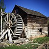 |
| Michael Keogan's Chimney | Alba Road
Keremeos BC | 49°19′54″N 119°34′07″W / 49.3316°N 119.5686°W / 49.3316; -119.5686 (Michael Keogan's Chimney) | Keremeos municipality (20348) | |
Upload Photo |
| Granite Creek Town Site and Cemetery | Granite Street, SE of Coalmont
Regional District of Okanagan-Similkameen BC | 49°30′19″N 120°40′52″W / 49.5052°N 120.6811°W / 49.5052; -120.6811 (Granite Creek Town Site and Cemetery) | Regional District of Okanagan-Similkameen municipality (20165) | |
Upload Photo |
| Bike Barn | 300 Westminster Avenue West
Penticton BC | 49°29′57″N 119°35′53″W / 49.4991°N 119.598°W / 49.4991; -119.598 (Bike Barn) | Penticton municipality (6782) | |  |
| Fairview Cemetery | 1136 Fairview Road
Penticton BC | 49°29′12″N 119°35′28″W / 49.4866°N 119.591°W / 49.4866; -119.591 (Fairview Cemetery) | Penticton municipality (6795) | |  |
| Gibson House | 112 Eckhardt Avenue West
Penticton BC | 49°29′33″N 119°35′28″W / 49.4924°N 119.591°W / 49.4924; -119.591 (Gibson House) | Penticton municipality (6775) | |  |
| Gyro Bandshell | 24 Lakeshore Drive West
Penticton BC | 49°30′07″N 119°35′42″W / 49.5019°N 119.595°W / 49.5019; -119.595 (Gyro Bandshell) | Penticton municipality (6798) | |  |
| Kettle Valley Railway Station | 216 Hastings Avenue
Penticton BC | 49°29′04″N 119°35′38″W / 49.4845°N 119.594°W / 49.4845; -119.594 (Kettle Valley Railway Station) | Penticton municipality (6783) | |
Upload Photo |
| Leir House | 220 Manor Park Avenue
Penticton BC | 49°29′04″N 119°35′02″W / 49.4844°N 119.584°W / 49.4844; -119.584 (Leir House) | Penticton municipality (6774) | |
Upload Photo |
| Munson Mountain | 650 Lower Bench Road
Penticton BC | 49°30′56″N 119°34′26″W / 49.5155°N 119.574°W / 49.5155; -119.574 (Munson Mountain) | Penticton municipality (6800) | | 
More images |
| Munson/Cleland Property | 10 Upper Bench Road South
Penticton BC | 49°30′12″N 119°33′43″W / 49.5032°N 119.562°W / 49.5032; -119.562 (Munson/Cleland Property) | Penticton municipality (6796) | |
Upload Photo |
| Penticton High School | 158 Main Street
Penticton BC | 49°29′32″N 119°35′13″W / 49.4923°N 119.587°W / 49.4923; -119.587 (Penticton High School) | Penticton municipality (6776) | |
Upload Photo |
| Penticton Post Office | 301 Main Street
Penticton BC | 49°29′56″N 119°35′33″W / 49.4988°N 119.5925°W / 49.4988; -119.5925 (Penticton Post Office) | Penticton municipality (6780) | |  |
| Penticton Provincial Courthouse | 100 Main Street
Penticton BC | 49°30′06″N 119°35′38″W / 49.5018°N 119.594°W / 49.5018; -119.594 (Penticton Provincial Courthouse) | Penticton municipality (6799) | |  |
| Riordan House | 689 Winnipeg Street
Penticton BC | 49°29′33″N 119°35′35″W / 49.4924°N 119.593°W / 49.4924; -119.593 (Riordan House) | Penticton municipality (6779) | |  |
| S.S. Naramata | 1099 Lakeshore Drive West
Penticton BC | 49°30′08″N 119°36′43″W / 49.5022°N 119.612°W / 49.5022; -119.612 (S.S. Naramata) | British Columbia (6186) | |  |
| S.S. Sicamous | 1075 Lakeshore Drive West
Penticton BC | 49°30′07″N 119°36′40″W / 49.5019°N 119.611°W / 49.5019; -119.611 (S.S. Sicamous) | Penticton municipality (6777) | | 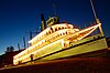
More images |
| Warren House[1] | 434 Lakeshore Drive West
Penticton BC | 49°30′05″N 119°36′00″W / 49.5015°N 119.6°W / 49.5015; -119.6 (Warren House) | Penticton municipality (6797) | |
Upload Photo |
| White Lodge | 1425 McMillan Avenue
Penticton BC | 49°30′45″N 119°33′43″W / 49.5126°N 119.562°W / 49.5126; -119.562 (White Lodge) | Penticton municipality (6778) | |
Upload Photo |
| Manning Park Lodge | 7500 Highway 3
Near Princeton BC | 49°03′47″N 120°47′10″W / 49.0631°N 120.786°W / 49.0631; -120.786 (Manning Park Lodge) | British Columbia (18053) | |
Upload Photo |
| Monument 83 |
Princeton BC | 49°00′01″N 120°38′46″W / 49.0004°N 120.646°W / 49.0004; -120.646 (Monument 83) | British Columbia (18048) | |
Upload Photo |
| Staff Residence | Highway 3
Near Princeton BC | 49°03′49″N 120°47′06″W / 49.0637°N 120.785°W / 49.0637; -120.785 (Staff Residence) | British Columbia (18055) | |
Upload Photo |
| Windy Joe Lookout |
Princeton BC | 49°02′38″N 120°45′18″W / 49.0439°N 120.755°W / 49.0439; -120.755 (Windy Joe Lookout) | British Columbia (18052) | |
Upload Photo |
| Former Superintendent’s Residence |
Summerland BC | 49°33′56″N 119°39′07″W / 49.5655°N 119.652°W / 49.5655; -119.652 (Former Superintendent’s Residence) | Federal (10133) | |  |
| Sod-Roofed Cabin | 4500 Landry Crescent
Summerland BC | 49°34′58″N 119°38′31″W / 49.5828°N 119.642°W / 49.5828; -119.642 (Sod-Roofed Cabin) | Summerland municipality (21064) | |
Upload Photo |
 From Wikipedia the free encyclopedia


.jpg)
.jpg)


.jpg)