List of municipalities in Acre
 From Wikipedia the free encyclopedia
This is a list of the municipalities in the state of Acre (AC), located in the North Region of Brazil. Acre is divided into 22 municipalities, which are grouped into 5 immediate regions, which are grouped into 2 intermediate regions.[1]
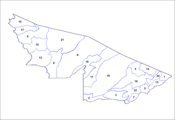 Municipalities of Acre, Brazil
 | Intermediate Region | Immediate Region | # | Municipality | Population (2018)[2] | Coordinates[3] |
| Rio Branco | Brasiléia | 2 | Assis Brasil | 7,300 | 10°56′29″S 69°34′01″W / 10.94139°S 69.56694°W / -10.94139; -69.56694 |
| 3 | Brasiléia | 25,848 | 11°00′58″S 68°44′53″W / 11.01611°S 68.74806°W / -11.01611; -68.74806 |
| 7 | Epitaciolândia | 18,122 | 11°01′44″S 68°44′29″W / 11.02889°S 68.74139°W / -11.02889; -68.74139 |
| 22 | Xapuri | 19,048 | 10°39′06″S 68°30′16″W / 10.65167°S 68.50444°W / -10.65167; -68.50444 |
| Rio Branco | 1 | Acrelândia | 15,020 | 09°49′40″S 66°53′00″W / 9.82778°S 66.88333°W / -9.82778; -66.88333 |
| 4 | Bujari | 10,111 | 09°49′50″S 67°57′08″W / 9.83056°S 67.95222°W / -9.83056; -67.95222 |
| 5 | Capixaba | 11,456 | 10°34′22″S 67°40′32″W / 10.57278°S 67.67556°W / -10.57278; -67.67556 |
| 13 | Plácido de Castro | 19,565 | 10°20′07″S 67°11′08″W / 10.33528°S 67.18556°W / -10.33528; -67.18556 |
| 14 | Porto Acre | 18,180 | 09°35′18″S 67°31′57″W / 9.58833°S 67.53250°W / -9.58833; -67.53250 |
| 16 | Rio Branco (state capital) | 401,155 | 09°58′29″S 67°48′36″W / 9.97472°S 67.81000°W / -9.97472; -67.81000 |
| 20 | Senador Guiomard | 22,810 | 10°09′08″S 67°44′21″W / 10.15222°S 67.73917°W / -10.15222; -67.73917 |
| Sena Madureira | 11 | Manoel Urbano | 9,336 | 08°50′20″S 69°15′35″W / 8.83889°S 69.25972°W / -8.83889; -69.25972 |
| 18 | Santa Rosa do Purus | 6,362 | 09°25′58″S 70°29′36″W / 9.43278°S 70.49333°W / -9.43278; -70.49333 |
| 19 | Sena Madureira | 45,177 | 09°03′56″S 68°39′25″W / 9.06556°S 68.65694°W / -9.06556; -68.65694 |
| Cruzeiro do Sul | Cruzeiro do Sul | 6 | Cruzeiro do Sul | 87,673 | 07°37′52″S 72°40′12″W / 7.63111°S 72.67000°W / -7.63111; -72.67000 |
| 10 | Mâncio Lima | 18,638 | 07°36′51″S 72°53′45″W / 7.61417°S 72.89583°W / -7.61417; -72.89583 |
| 12 | Marechal Thaumaturgo | 18,430 | 08°56′28″S 72°47′30″W / 8.94111°S 72.79167°W / -8.94111; -72.79167 |
| 15 | Porto Walter | 11,720 | 08°16′07″S 72°44′38″W / 8.26861°S 72.74389°W / -8.26861; -72.74389 |
| 17 | Rodrigues Alves | 18,504 | 07°44′30″S 72°38′10″W / 7.74167°S 72.63611°W / -7.74167; -72.63611 |
| Tarauacá | 8 | Feijó | 34,675 | 08°09′51″S 70°21′13″W / 8.16417°S 70.35361°W / -8.16417; -70.35361 |
| 9 | Jordão | 8,159 | 09°26′03″S 71°53′02″W / 9.43417°S 71.88389°W / -9.43417; -71.88389 |
| 21 | Tarauacá | 41,976 | 08°09′41″S 70°45′56″W / 8.16139°S 70.76556°W / -8.16139; -70.76556 |
See also[edit]
References[edit]


