Mount Emerald Wind Farm
 From Wikipedia the free encyclopedia
| Mount Emerald Wind Farm | |
|---|---|
 | |
| Country | Australia |
| Coordinates | 17°11′S 145°22′E / 17.183°S 145.367°E |
| Status | Operational |
| Construction began | 14 February 2017 |
| Commission date | August 2018 |
| Construction cost | $400 million |
| Owner(s) | |
| Operator(s) | RATCH-Australia |
| Wind farm | |
| Type | Onshore |
| Hub height | 84 m (276 ft) Vestas V112 90 m (295 ft) Vestas V117 |
| Rotor diameter | 112 m (367 ft) 117 m (384 ft) |
| Rated wind speed | 50 km/h (13.9 m/s) |
| Site area | 2,400 ha (24 km2) |
| Site elevation | 900 m (2,953 ft) |
| Power generation | |
| Units operational | 16 × 3.3 MW 37 × 3.45 MW |
| Make and model | Vestas V112-3.3MW Vestas V117-3.45MW |
| Nameplate capacity | 180.5 MW |
| Annual net output | 500-600 GWh |
| External links | |
| Website | mtemeraldwindfarm |
Mount Emerald Wind Farm is a 180 MW wind farm situated on Mount Emerald, in Arriga, Shire of Mareeba, Queensland, Australia.[1] It is approximately 8 km WNW of Tolga, and 49 km SW of Cairns. The project is a joint venture between Port Bajool (land owner) and RATCH-Australia (wind farm developer and operator). RATCH-Australia bought the project from Transfield Services in July 2011.[2] The wind farm incorporates 53 turbines.[3]
Construction[edit]
Approval from the state government came in April 2015.[4] Federal government approval happened in November 2015, subject to 35 conditions aimed at protecting native species.[4] The site was formerly used as a military training area in World War II so the site had to be carefully inspected to find any unexpoded ordnance; several were found and safely destroyed.[5]
Operations[edit]
The wind farm registered its first grid output in August 2018 and reached maximum output in January 2019. The electricity network around the wind farm is generally constrained; this has an impact on the total amount of electricity it can receive from the wind farm. Studies are being undertaken to increasing the capacity of the network using technologies such as synchronous condensers and grid-scale batteries.[6][7]
| Year | Total | Jan | Feb | Mar | Apr | May | Jun | Jul | Aug | Sep | Oct | Nov | Dec |
|---|---|---|---|---|---|---|---|---|---|---|---|---|---|
| 2018 | 114,356 | N/A | N/A | N/A | N/A | N/A | N/A | N/A | 2,239 | 27,237 | 19,132 | 30,535 | 35,213 |
| 2019 | 455,639 | 39,124 | 21,108 | 33,043 | 62,106 | 53,452 | 45,636 | 33,884 | 45,804 | 40,882 | 33,083 | 26,186 | 21,331 |
| 2020 | 348,260 | 20,204 | 10,891 | 36,588 | 38,551 | 48,914 | 56,223 | 17,879 | 14,075 | 33,172 | 15,113 | 37,952 | 18,698 |
| 2021 | 28,953 | 14,298 | 36,514 | 43,141 | 52,500 | 30,136 | 32,432 | 63,443 | 59,085 | 20,474 | 25,138 | 32,015 | |
| 2022 | 21,812 | 23,242 | 26,568 | 50,452 | 29,027 | 53,770 | 40,093 | 51,827 | 37,556 | 35,440 | 27,244 | 26,171 | |
| 2023 | 18,820 | 28,533 | 23,251 | 32,791 | 58,862 | 43,962 | 54,560 | 56,183 | 61,325 |
Environmental impact[edit]
Environmental groups have claimed that the construction of roads and bases for the wind turbines caused significant destruction of the formerly untouched wilderness.[8]
Photo gallery[edit]
-
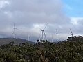 Multiple Wind turbines
 -
 Mount Emerald Wind Farm Substation construction
 -
 Mount Emerald Wind Farm entry
 -
 Mount Emerald Wind Farm Opening Plaque
 -
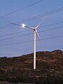 Mount Emerald wind farm turbine and moon


See also[edit]
References[edit]
- ^ "MT EMERALD WIND FARMREVISED A-WEIGHTED NOISE ASSESSMENT" (PDF).
- ^ "Mount Emerald Newsletter 3" (PDF). RATCH-Australia. Archived from the original (PDF) on 9 April 2013. Retrieved 30 January 2012.
- ^ Sexton-McGrath, Kristy (27 January 2022). "Fears of 'giant ring of steel' in Far North Queensland with wind farms set to border national parks". ABC News. Retrieved 16 October 2023.
- ^ a b Kim, Sharnie; Sharon, Molloy (27 November 2015). "Mt Emerald wind farm proposed for Atherton Tablelands gets conditional Federal approval". ABC News. Retrieved 16 October 2023.
- ^ "Where the wild wind blows … on the job at the Mount Emerald Wind Farm |". EcoGeneration. 29 January 2018. Retrieved 26 November 2022.
- ^ Lee, Dan (30 June 2022). "On the fringes: the outer edges of the NEM remain the most prone to volatile MLFs". WattClarity. Retrieved 26 November 2022.
- ^ "Network Planning: North Queensland System Strength Constraints" (PDF). Powerlink Queensland. Retrieved 26 November 2022.
- ^ "'This is utter madness': The massive wind farms angering fans of renewable energy". ABC News. 11 December 2021.
