Namatanai Rural LLG
 From Wikipedia the free encyclopedia
Namatanai Rural LLG | |
|---|---|
 | |
| Country | Papua New Guinea |
| Province | New Ireland Province |
| Time zone | UTC+10 (AEST) |

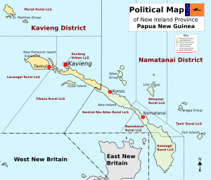
Namatanai Rural LLG is a local government area in New Ireland Province, Papua New Guinea. The LLG is located in Namatanai District and the LLG headquarters is Namatanai.
The LLG is accessible by road from Kavieng and is bordered by Sentral Niu Ailan Rural LLG in the north, Matalai Rural LLG in the south east and Konoagil Rural LLG in the west coast. The local language is Patpatar language with its Pala, Hinsaal, Sokarek and Sokirik dialects while the Niwer Mil language is spoken by Tanga Islanders who have bought blocks of land at Bo village.
The LLG president is Michael Singan. Current Population is 20,003 as per 2011 PNG National Census Report.
Wards[edit]
- 01. Palabong
- 02. Kabanut (including Umudu village)[1]
- 03. Matakan
- 04. Burau
- 05. Rasirik
- 06. Labur
- 07. Loloba
- 08. Kanapit
- 09. Pire
- 10. Namatanai
- 12. Salimun
- 13. Bisapu
- 14. Sopau
- 15. Rativis
- 16. Hipaling
- 17. Himau
- 18. Nokon
- 19. Hipakat
- 20. Kembeng
- 21. Sena
- 81. Namatanai Urban
References[edit]
- ^ United Nations in Papua New Guinea (2018). "Papua New Guinea Village Coordinates Lookup". Humanitarian Data Exchange. 1.31.9.
- "Census Figures by Wards - Islands Region". www.nso.gov.pg. 2011 National Population and Housing Census: Ward Population Profile. Port Moresby: National Statistical Office, Papua New Guinea. 2014.
- "Final Figures". www.nso.gov.pg. 2011 National Population and Housing Census: Ward Population Profile. Port Moresby: National Statistical Office, Papua New Guinea. 2014.
- OCHA FISS (2018). "Papua New Guinea administrative level 0, 1, 2, and 3 population statistics and gazetteer". Humanitarian Data Exchange. 1.31.9.
- United Nations in Papua New Guinea (2018). "Papua New Guinea Village Coordinates Lookup". Humanitarian Data Exchange. 1.31.9.
- Patpatar at Ethnologue (18th ed., 2015)