Niderviller
 From Wikipedia the free encyclopedia
Niderviller | |
|---|---|
_mairie.jpg) The town hall in Niderviller | |
.svg) Coat of arms | |
Location of Niderviller  | |
 Niderviller  Niderviller | |
| Coordinates: 48°42′49″N 7°06′31″E / 48.7136°N 7.1086°E | |
| Country | France |
| Region | Grand Est |
| Department | Moselle |
| Arrondissement | Sarrebourg-Château-Salins |
| Canton | Phalsbourg |
| Intercommunality | CC Sarrebourg Moselle Sud |
| Government | |
| • Mayor (2020–2026) | Marie-Véronique Buschel[1] |
| Area 1 | 10.75 km2 (4.15 sq mi) |
| Population (2021)[2] | 1,172 |
| • Density | 110/km2 (280/sq mi) |
| Time zone | UTC+01:00 (CET) |
| • Summer (DST) | UTC+02:00 (CEST) |
| INSEE/Postal code | 57505 /57565 |
| Elevation | 257–364 m (843–1,194 ft) (avg. 300 m or 980 ft) |
| 1 French Land Register data, which excludes lakes, ponds, glaciers > 1 km2 (0.386 sq mi or 247 acres) and river estuaries. | |

Niderviller (French pronunciation: [nidɛʁvilɛʁ]; German: Niederweiler) is a commune in the Moselle department in Grand Est in north-eastern France. It is mostly known for the Niderviller pottery, established in 1735 and still producing there.
Geography
[edit]Niderviller is located south-east of Sarrebourg.
The commune is served by the departmental roads 45 and 96. It is also crossed by the Marne-Rhine canal, which passes through the Niderviller Underground Tunnel.
-
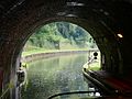 The Underground Tunnel
 -
 The village entrance

_entr%C3%A9e.jpg)
Toponymy
[edit]The name of the village come from the germanic words nieder "down, from below" and weiler "hamlet".[3]
Ancient names: Niederwilre (1163), Nyderwilre (15th century), Nyder-Wuelles (1525), Nidersweiller (1594),[4] Niderwiller (18th century), Nidreviller (1793), Niederweiler (1871–1918).
History
[edit]Niderviller, which was originally part of the Duchy of Lorraine, was ceded to France in 1661 (Treaty of Vincennes), along with the other localities of the provostry of Sarrebourg.
There was once a castle that belonged to General de Custine, who was killed by the revolutionaries in 1793.
In 1949, the castle was reconverted into an aerial hospital (a sort of sanatorium that uses fresh air) for sick children. It became a convalescent home for victims of cardiovascular accidents in 1982.
Sights
[edit]Religious monuments
[edit]- Église Sainte-Croix (Church of the Holy Cross): In 1762, lord of Niderviller, Jean-Louis Beyerlé, and owner of the Niderviller pottery factory, had the present bell tower built.[5]
- Sculpture descente de la Croix : a sculpture representing the descent from the Cross.
- War memorial
-
 Église Sainte-Croix
 -
 War memorial
 -
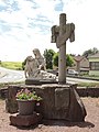 Sculpture Descente de la Croix
_%C3%A9glise_fa%C3%A7ade_du_clocher.jpg)
_monument_aux_morts.jpg)
_sculpture_descente_de_la_Croix.jpg)
Historical monuments
[edit]- Ruins of a Roman villa
- Castle, built around 1863 by Léopold Halphen for his son-in-law Théodore Cerfberr. Since March 1, 1982, it houses part of the Saint-Luc Specialised Rehabilitation Center in Abreschviller.
- Old castle des Custine : this castle is nowadays destroyed
Civilian and industrial buildings
[edit]- Niderviller Pottery factory: the first factory was built in 1735. Its products are the symbol of the village.
- Tile and brick factory
- Old mill
-
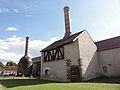 Pottery factory
 -
 Example of the factory production
 -
 Tile factory
_fa%C3%AFencerie_(03).jpg)

_Tuilerie_de_Niderviller_(01).jpg)
Cultural events and festivities
[edit]La vallée de la Bièvre en fête is a fair that highlights the culture, the crafts and the gastronomy of the local territory.[6]
Notable people
[edit]- Astolphe de Custine: a French artistocrat and writer who was born in Niderviller
See also
[edit]References
[edit]- ^ "Répertoire national des élus: les maires". data.gouv.fr, Plateforme ouverte des données publiques françaises (in French). 2 December 2020.
- ^ "Populations légales 2021" (in French). The National Institute of Statistics and Economic Studies. 28 December 2023.
- ^ Nègre, Ernest (1990). Toponymie générale de la France, Volume 1 (in French). Librairie Droz. ISBN 978-2-600-05898-8.
- ^ Lepage, Henri (1862). Dictionnaire topographique du département de la Meurthe (in French). Paris: Imprimerie impériale.
- ^ Sprung, Gilbert. "L'église". Niderviller (in French).
- ^ "Une foire ambitieuse pour la Vallée de la Bièvre à Niderviller". Le Républicain Lorrain. 12 October 2016.
External links
[edit] Media related to Niderviller at Wikimedia Commons
| International | |
|---|---|
| National | |