Pagoda Mountain
 From Wikipedia the free encyclopedia
| Pagoda Mountain | |
|---|---|
 North aspect | |
| Highest point | |
| Elevation | 13,497 ft (4,114 m)[1][2] |
| Prominence | 410 ft (125 m)[3] |
| Parent peak | Longs Peak (14,259 ft)[3][4] |
| Isolation | 0.71 mi (1.14 km)[3] |
| Coordinates | 40°14′57″N 105°37′35″W / 40.2493047°N 105.6262588°W[5] |
| Geography | |
 Pagoda Mountain Location in Colorado  Pagoda Mountain Pagoda Mountain (the United States) | |
| Country | United States |
| State | Colorado |
| County | Boulder County |
| Protected area | Rocky Mountain National Park |
| Parent range | Rocky Mountains Front Range |
| Topo map | USGS Isolation Peak |
| Geology | |
| Age of rock | Precambrian[7] |
| Type of rock | Granite of Longs Peak batholith[6] Biotite schist and gneiss[6] |
| Climbing | |
| Easiest route | class 3 scrambling[3] |
Pagoda Mountain is a 13,497-foot-elevation (4,114-meter) mountain summit in Boulder County, Colorado, United States.
Description[edit]
Pagoda Mountain is located one mile east of the Continental Divide in the Front Range of the Rocky Mountains.[4] The mountain is situated within Rocky Mountain National Park and is the fifth-highest peak in Boulder County.[8] Precipitation runoff from the mountain's south slope drains to North St. Vrain Creek via Hunters Creek and the north slope drains to Glacier Creek which is a tributary of the Big Thompson River. Topographic relief is significant as the summit rises 1,940 feet (590 meters) above Green Lake in one-half mile. The mountain's toponym was officially adopted in 1911 by the United States Board on Geographic Names and is so named because the mountain's shape resembles a pagoda.[5]
Climate[edit]
According to the Köppen climate classification system, Pagoda Mountain is located in an alpine subarctic climate zone with cold, snowy winters and cool to warm summers.[9] Due to its altitude, it receives precipitation all year, as snow in winter, and as thunderstorms in summer, with a dry period in late spring.
See also[edit]
- List of peaks in Rocky Mountain National Park
- Mountains of Boulder County, Colorado
- Thirteener
 Mountains portal
Gallery[edit]
-
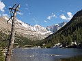
 North aspect, from Mills Lake
 -
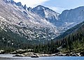 North aspect, from Mills Lake
 -
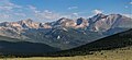
 Longs Peak (left) and Pagoda Mountain (right)
 -
 Left to right: Mount Alice, Chiefs Head Peak (centered), Pagoda Mountain, Longs Peak, Mount Meeker. Southeast aspect viewed across Wild Basin.
 -
 Pagoda Mountain centered


.jpg)
.jpg)
References[edit]
- ^ Robert M. Ormes (1992), Guide to the Colorado Mountains, Johnson Books, ISBN 9781555661946, p. 46.
- ^ "Pagoda Mountain, Colorado". Peakbagger.com. Retrieved April 25, 2023.
- ^ a b c d "Pagoda Mountain - 13,488' CO". listsofjohn.com. Retrieved April 25, 2023.
- ^ a b "Pagoda Mountain, Peakvisor.com". Retrieved April 25, 2023.
- ^ a b "Pagoda Mountain". Geographic Names Information System. United States Geological Survey, United States Department of the Interior. Retrieved April 25, 2023.
- ^ a b Geologic map of the Estes Park 30' x 60' quadrangle, north-central Colorado, W.A. Braddock, U.S. Geological Survey, 1984.
- ^ Lexicon of Geologic Names of the United States (including Alaska). Part 2 (1936), U.S. Government Printing Office, p. 2227.
- ^ Boulder County CO Peaks List, listsofjohn.com, Retrieved April 25, 2023.
- ^ Peel, M. C.; Finlayson, B. L.; McMahon, T. A. (2007). "Updated world map of the Köppen−Geiger climate classification". Hydrol. Earth Syst. Sci. 11. ISSN 1027-5606.
External links[edit]
- Weather forecast: Pagoda Mountain
- Pagoda Mountain rock climbing: Mountainproject.com
Places adjacent to Pagoda Mountain | ||||||||||||||||
|---|---|---|---|---|---|---|---|---|---|---|---|---|---|---|---|---|
| ||||||||||||||||