Pandavapura
 From Wikipedia the free encyclopedia
Pandavapura | |
|---|---|
Town | |
 Pandavapura Lake | |
| Coordinates: 12°30′N 76°40′E / 12.5°N 76.67°E | |
| Country | |
| State | Karnataka |
| District | Mandya |
| Government | |
| • Body | Town Municipal Council |
| Area | |
| • Town | 3.68 km2 (1.42 sq mi) |
| • Rural | 524 km2 (202 sq mi) |
| Population (2011)[1] | |
| • Town | 20,399 |
| • Density | 5,500/km2 (14,000/sq mi) |
| • Rural | 162,953 |
| Languages | |
| • Official | Kannada |
| Time zone | UTC+5:30 (IST) |
| PIN | 571434, 571435(R.S) |
| Vehicle registration | KA-54 & KA-11 |
| Website | www |


Pandavapura is a Municipality Town in Mandya district in the Indian state of Karnataka.
Geography[edit]
Pandavapura is located at 12°30′N 76°40′E / 12.5°N 76.67°E.[2] It has an average elevation of 709 metres (2326 feet).


Demographics[edit]
As of 2001[update] India census,[3] Pandavapura had a population of 18,236. Males constitute 51% of the population and females 49%. Pandavapura has an average literacy rate of 67%, higher than the national average of 59.5%: male literacy is 72%, and female literacy is 62%. In Pandavapura, 12% of the population is under 6 years of age.
History[edit]
The name Pandavapura means "Town of Pandavas". Puranas states that the Pandavas during their period of exile stayed here for some time, and Kunti, mother of the Pandavas, liked the hillock so much that it became one of her favorite haunts. The town is also named after the Pandavas because of their brief stay in this region. The name "French Rock" dates back to India's Pre-Independence days, the place was used as the camping ground by the French army, which came to help Tippu Sultan in his war against the British. It is believed that French named the small town as "French Rocks", as the town is in the vicinity of two rocky hills. After Indian Independence, these rocky hills called as "Kunti Betta" by locals. There was another smaller hill called "Kauravara betta" on the western side of the town which has been mined out of existence for its stones.
Pandavapura is approximately 130 km from Bangalore and 25 km from Mysore.
Transport[edit]

Pandavapura is well connected by trains and buses. Most of the trains which run between Bengaluru and Mysuru have a stoppage in Pandavapura. The Pandavapura railway station (Station Code:PANP) is 4 km away from the town. There are a few direct buses (both KSRTC & private) that ply between Bengaluru and Pandavapura [4]. KSRTC also has a bus depot in Pandavapura, under Mandya division.
Tourism[edit]
Pandavapura town is surrounded by well-known tourist spots.
- Melukote
- Krishnaraja Sagar
- Kunthi betta
- Kere Thonnur
Notable people[edit]
- H. R. Shastry - veteran actor in Kannada, was born in Halebeedu village
- Vijaya Narasimha - noted lyricist in the Kannada Film Industry, was born in Halebeedu village
- Jayalakshmi Seethapura - noted writer, folklorist; born in Seethapura village
- K. S. Puttannaiah - Leader and politician
- C. S. Puttaraju - politician
Image gallery[edit]
-
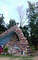 Assumption Church
 -
 Taluk hospital
 -
 Amma Temple
 -
 Temple on highway
 -
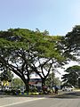 Mysore Road
 -
 Bus Station


See also[edit]
- Narayanapura
- Kere Thonnur
- Shingapoore
- Naganahalli
- Byadarahalli
- Yeliyur
- Gummanahalli
- Krishnarajpet
- Chinakurali
References[edit]
- ^ "Census Data Handbook 2011" (PDF). Retrieved 15 May 2024.
- ^ Falling Rain Genomics, Inc - Pandavapur
- ^ "Census of India 2001: Data from the 2001 Census, including cities, villages and towns (Provisional)". Census Commission of India. Archived from the original on 16 June 2004. Retrieved 1 November 2008.
- ^ "Karnataka Legislative Assembly Members". Archived from the original on 6 March 2012. Retrieved 20 February 2013.