Petit-Couronne
 From Wikipedia the free encyclopedia
Petit-Couronne | |
|---|---|
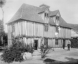
 Pierre Corneille's house | |
| Coordinates: 49°23′11″N 1°01′42″E / 49.3864°N 1.0283°E | |
| Country | France |
| Region | Normandy |
| Department | Seine-Maritime |
| Arrondissement | Rouen |
| Canton | Le Grand-Quevilly |
| Intercommunality | Métropole Rouen Normandie |
| Government | |
| • Mayor (2020–2026) | Joël Bigot[1] |
| Area 1 | 12.8 km2 (4.9 sq mi) |
| Population (2021)[2] | 8,688 |
| • Density | 680/km2 (1,800/sq mi) |
| Time zone | UTC+01:00 (CET) |
| • Summer (DST) | UTC+02:00 (CEST) |
| INSEE/Postal code | 76497 /76650 |
| Elevation | 2–108 m (6.6–354.3 ft) (avg. 15 m or 49 ft) |
| 1 French Land Register data, which excludes lakes, ponds, glaciers > 1 km2 (0.386 sq mi or 247 acres) and river estuaries. | |
Petit-Couronne (French pronunciation: [pəti kuʁɔn], before 1984: Le Petit-Couronne)[3] is a commune in the Seine-Maritime department in the Normandy region in northern France.
Geography
[edit]A port town of oil refineries, light industry and forestry situated by the banks of the Seine, just 4 miles (6.4 km) south of the centre of Rouen at the junction of the D3 and the N338 roads.
Coat of arms
[edit] | The arms of Petit-Couronne are blazoned : Azure, an anchor argent surmounted by 2 torches in saltire Or, and on a chief wavy azure fimbriatd argent, 3 lions heads erased gules. (created 1986)[citation needed]
|
Population
[edit]| Year | Pop. | ±% p.a. |
|---|---|---|
| 1968 | 4,861 | — |
| 1975 | 5,686 | +2.26% |
| 1982 | 6,340 | +1.57% |
| 1990 | 8,122 | +3.14% |
| 1999 | 8,621 | +0.66% |
| 2007 | 9,057 | +0.62% |
| 2012 | 9,278 | +0.48% |
| 2017 | 8,619 | −1.46% |
| Source: INSEE[4] | ||
Places of interest
[edit]- Menhirs from pre-Roman times.
- The church of St. Aubin, dating from the seventeenth century.
- The sixteenth-century house of writer Pierre Corneille, now a museum.
- Several 17th/18th-century houses and a dovecote.
People
[edit]- Pierre Corneille, writer, poet and dramatist once lived here.
- Marcelly, full name Marcel Jules Turmel, Music-hall singer (1882-1966)
- Germaine Beaumont, writer and journalist, was born here.
Twin towns
[edit]See also
[edit]References
[edit]- ^ "Répertoire national des élus: les maires". data.gouv.fr, Plateforme ouverte des données publiques françaises (in French). 2 December 2020.
- ^ "Populations légales 2021" (in French). The National Institute of Statistics and Economic Studies. 28 December 2023.
- ^ Décret du 13 novembre 1984 portant changement de nom de communes, Journal officiel de la République française n° 0270, 18 November 1984, p. 10523.
- ^ Population en historique depuis 1968, INSEE
External links
[edit]- Official town website (in French)
- Website of the Museum of Pierre Corneille (in French)


