Puerto Rico Highway 500
 From Wikipedia the free encyclopedia
Highway 500 | ||||
|---|---|---|---|---|
| Ruta 500 | ||||
.svg) | ||||
| Route information | ||||
| Maintained by Puerto Rico DTPW | ||||
| Length | 2.9 km[1] (1.8 mi) | |||
| Major junctions | ||||
| West end | Sector La Cotorra in Canas | |||
| ||||
| East end | ||||
| Location | ||||
| Country | United States | |||
| Territory | Puerto Rico | |||
| Municipalities | Ponce | |||
| Highway system | ||||
| ||||


Puerto Rico Highway 500 (PR-500) is a tertiary[2] road in Ponce, Puerto Rico. The highway has both of its endpoints, as well as all of its length, entirely within the Ponce city limits. It runs east to west.
Route description[edit]
The road has its eastern terminus at PR-132 (Calle Villa), in Barrio Canas Urbano, and its western terminus in Barrio Canas. A one-lane dirt road leads to PR-549 from there. The only major road PR-500 intersects is Avenida Baramaya (PR-9), at km 0.8. Prior to that, at km 0.3, PR-500 connects to PR-163 (Avenida Las Américas). The road ends at km 2.3, where the Vertedero Municipal de Ponce (Ponce's Municipal Waste Yard) is located. From km 2.3 an unmarked dirt road leads to PR-549, which leads to barrio Quebrada Limón in the western portion of the municipality of Ponce.
In the 2000s decade, PR-500 was no longer transited by the oversized Ponce Cement (now CEMEX) trucks. Highway 500 is about one and one-half miles long, making one of the shortest highways in Puerto Rico. It is lined by residential areas with a short section lined by the Calle Villa Final industrial park, a light-industry industrial park.
In August 2011, Senator Larry Seilhamer Rodríguez presented a bill into the Puerto Rico Senate that would extend PR-500 westward to connect with PR-2 in the area Guayanilla.[3][4]
-
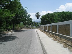 A stretch of Puerto Rico Highway 500 heading north near PR-163 in Barrio Canas
 -
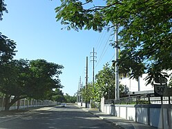 A stretch of PR-500 heading south in Barrio Canas
 -
 Western terminus of PR-163 at PR-500 junction in Barrio Canas Urbano, looking west
.jpg)
.jpg)
,_cerca_del_R%C3%ADo_Pastillo,_Bo._Canas,_Ponce,_Puerto_Rico,_mirando_al_suroeste_desde_INT_PR-163_y_PR-500_(DSC01368).jpg)
History[edit]
The highway is a wide two-way roadway originally designed to accommodate the oversized trucks used by the Ponce Cement, Inc. plant in barrio Magueyes, on road PR-123. The trucks were used to transport limestone soil from the northern slopes of the western barrio Canas hills, near barrio Tallaboa in Peñuelas to the cement plant on PR-123.[5][6] The road runs from its eastern terminus at PR-132 (Calle Villa), which is the road leading from Guayanilla to Ponce through Peñuelas, to its western terminus at Barrio Canas where it ends at the Ponce Municipal Waste and Recycling Yard.
Major intersections[edit]
The entire route is located in Ponce.
| Location | km[1] | mi | Destinations | Notes | |
|---|---|---|---|---|---|
| Canas | 2.9 | 1.8 | Western terminus of PR-500 at Sector La Cotorra; a dirt path leads to PR-549 | ||
| 1.1– 1.0 | 0.68– 0.62 | Incomplete diamond interchange | |||
| Canas Urbano | 0.4 | 0.25 | |||
| 0.0 | 0.0 | Eastern terminus of PR-500 | |||
| 1.000 mi = 1.609 km; 1.000 km = 0.621 mi | |||||
See also[edit]
References[edit]
- ^ a b Google (1 March 2020). "PR-500" (Map). Google Maps. Google. Retrieved 1 March 2020.
- ^ PRHTA Design Manual: Chapter 1, General Design Criteria. Departamento de Transportación y Obras Publicas de Puerto Rico. page 1-2. Accessed 9 May 2019.
- ^ Seilhamer propone Corredor del Sur. Jason Rodríguez Grafal. La Perla del Sur. Ponce, Puerto Rico. 4 August 2011. Retrieved 4 November 2011.
- ^ National Geographic Maps (2011). Puerto Rico (Map). 1:125,000. Adventure Map (Book 3107). Evergreen, Colorado: National Geographic Maps. ISBN 978-1566955188. OCLC 756511572.
- ^ Mounir T. Moussa, George A. Seiglie. Revision of Mid-Tertiary Stratigraphy of Southwestern Puerto Rico. Bulletin. American Association of Petroleum Geologists. Vol. 54, Issue 10 (October, 1970; pp. 1887-1898.) Page 1894.
- ^ Mounir T. Moussa, George A. Seiglie. Revision of Mid-Tertiary Stratigraphy of Southwestern Puerto Rico. Bulletin. American Association of Petroleum Geologists. Vol. 54, Issue 10 (October 1970; pp. 1887-1898.) Page 1894.
External links[edit]
- Historia de las Carreteras de Puerto Rico. Retrieved 11 March 2010. (in Spanish)
- Roads in Porto Rico. By Manuel Victor Domenech, Former Commissioner of the Interior, in The Overland Monthly. Vol 73, No, 4; April, 1919. Page 321. Retrieved 11 March 2010.
- Guía de Carreteras Principales, Expresos y Autopistas (in Spanish)