Puerto Rico Highway 805
 From Wikipedia the free encyclopedia
Highway 805 | ||||
|---|---|---|---|---|
| Ruta 805 | ||||
| Route information | ||||
| Maintained by Puerto Rico DTPW | ||||
| Length | 7.3 km[1] (4.5 mi) | |||
| Major junctions | ||||
| West end | ||||
| East end | ||||
| Location | ||||
| Country | United States | |||
| Territory | Puerto Rico | |||
| Municipalities | Corozal | |||
| Highway system | ||||
| ||||

Puerto Rico Highway 805 (PR-805) is an east–west road located in the municipality of Corozal in Puerto Rico.[2] With a length of 7.3 km (4.5 mi), it extends from its intersection with PR-568 near the Cuchillas boundary, passing through Negros barrio until its junction with PR-803 in Palos Blancos area.[3]
Route description[edit]
Puerto Rico Highway 805 is a rural road with a single lane per direction along its entire length. In Negros, it extends from its junction with PR-568 near Cuchillas to its intersection with PR-807, passing though several neighborhoods and sectors with scenic views of the northern coast of Puerto Rico. In Palos Blancos, PR-805 leaves PR-807 intersection until its end at PR-803 junction near the Monte Choca State Forest.[4]
-
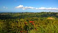
 View of the northern coast of Puerto Rico from PR-805 in Negros barrio
 -
 View of the Cordillera Central mountains from PR-805 in Negros barrio
 -
 Looking north from PR-805 in Palos Blancos barrio


History[edit]
Prior to its numerical designation, PR-805 was only known as Camino de Negros. The current numerical designation corresponds to the 1953 Puerto Rico highway renumbering, a process implemented by the Puerto Rico Department of Transportation and Public Works (Spanish: Departamento de Transportación y Obras Públicas) that increased the insular highway network to connect existing routes with different locations around Puerto Rico.[5]
Major intersections[edit]
The entire route is located in Corozal.
-
 Western terminus of PR-805 at PR-568 junction in Negros barrio, looking east
 -
 PR-805 east approaching PR-807 intersection in Negros barrio
 -
 PR-803 south near the eastern terminus of PR-805 in Palos Blancos barrio


| Location | km[1] | mi | Destinations | Notes | |
|---|---|---|---|---|---|
| Negros | 0.0 | 0.0 | Western terminus of PR-805 | ||
| Negros–Palos Blancos line | 3.7 | 2.3 | |||
| Palos Blancos | 7.3 | 4.5 | Eastern terminus of PR-805 | ||
| 1.000 mi = 1.609 km; 1.000 km = 0.621 mi | |||||
See also[edit]
References[edit]
- ^ a b Google (29 February 2020). "PR-805" (Map). Google Maps. Google. Retrieved 29 February 2020.
- ^ National Geographic Maps (2011). Puerto Rico (Map). 1:125,000. Adventure Map (Book 3107). Evergreen, Colorado: National Geographic Maps. ISBN 978-1566955188. OCLC 756511572.
- ^ "Tránsito Promedio Diario (AADT)". Transit Data (Datos de Transito) (in Spanish). DTOP PR. p. 129. Archived from the original on 1 April 2019.
- ^ "PR-805, Corozal, Puerto Rico". pr.geoview.info. Retrieved 7 February 2020.
- ^ "Corozal, Memoria Núm. 61" (PDF). Puerto Rico Planning Board (in Spanish). 1955. Retrieved 22 August 2023.
External links[edit]
 Media related to Puerto Rico Highway 805 at Wikimedia Commons
This Corozal, Puerto Rico location article is a stub. You can help Wikipedia by expanding it. |
This Puerto Rico road-related article is a stub. You can help Wikipedia by expanding it. |