Sainte-Anne-du-Lac
 From Wikipedia the free encyclopedia
Sainte-Anne-du-Lac | |
|---|---|
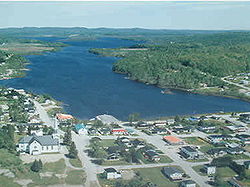
 Sainte-Anne-du-Lac and Lake Tapani | |
 Location within Antoine-Labelle RCM | |
| Coordinates: 46°53′N 75°20′W / 46.883°N 75.333°W[1] | |
| Country | Canada |
| Province | Quebec |
| Region | Laurentides |
| RCM | Antoine-Labelle |
| Settled | 1870s |
| Constituted | December 30, 1976 |
| Government | |
| • Mayor | Jocelyne Lafond |
| • Federal riding | Laurentides—Labelle |
| • Prov. riding | Labelle |
| Area | |
| • Total | 345.73 km2 (133.49 sq mi) |
| • Land | 320.73 km2 (123.83 sq mi) |
| Population (2021)[3] | |
| • Total | 556 |
| • Density | 1.7/km2 (4/sq mi) |
| • Pop. 2016-2021 | |
| • Dwellings | 422 |
| Time zone | UTC−05:00 (EST) |
| • Summer (DST) | UTC−04:00 (EDT) |
| Postal code(s) | |
| Area code | 819 |
| Highways | |
| Website | www |
Sainte-Anne-du-Lac is a municipality and village in the Laurentides region of Quebec, Canada, part of the Antoine-Labelle Regional County Municipality.
Sainte-Anne-du-Lac is the northernmost community in the Laurentides region, about 45 km (28 mi) from Mont-Laurier. The village itself is located at the northern terminus of Quebec Route 309, on the south shore of Lake Tapani.
History
[edit]Settlement began around 1870. In 1916, the Parish of Sainte-Anne-du-Lac was formed, and the following year, the first school was built. Also in 1917, the Township of Décarie was established, and incorporated as a township municipality in 1920. It was named in honour of Jérémie-Louis Décarie.[1] The township municipality used to extend to the Lièvre River, but the south-eastern portion was ceded in 1928 to the then newly created Municipality of Mont-Saint-Michel.[4]
In 1950, the village itself separated from the township to form the Village Municipality of Sainte-Anne-du-Lac.[1]
On December 30, 1976, the township and village municipalities merged to form the current Municipality of Sainte-Anne-du-Lac.[1]
Demographics
[edit]| 2021 | 2016 | |
|---|---|---|
| Population | 556 (-3.3% from 2016) | 575 (-7.1% from 2011) |
| Land area | 320.73 km2 (123.83 sq mi) | 322.59 km2 (124.55 sq mi) |
| Population density | 1.7/km2 (4.4/sq mi) | 1.8/km2 (4.7/sq mi) |
| Median age | 59.6 (M: 60.4, F: 58.0) | 55.5 (M: 57.4, F: 54.4) |
| Private dwellings | 422 (total) | 364 (total) |
| Median household income | $37,760 |
|
| ||||||||||||||||||||||||||||||||||||
| 1991, 1996.[9] 2001, 2006.[10] 2011, 2016[11] | |||||||||||||||||||||||||||||||||||||
Private dwellings occupied by usual residents (2021): 299 (total dwellings: 422)[3]
Mother tongue:
- French as first language: 95.65%
- English as first language: 2.61%
- English and French as first language: 0.87%
- Other as first language: 0.87%
Local government
[edit]List of former mayors:
- Aimé Lachapelle (...–2013)
- Annick Brault (2013–2021)
- Jocelyne Lafond (2021–present)
See also
[edit]References
[edit]- ^ a b c d "Banque de noms de lieux du Québec: Reference number 77617". toponymie.gouv.qc.ca (in French). Commission de toponymie du Québec.
- ^ a b "Répertoire des municipalités: Geographic code 79115". www.mamh.gouv.qc.ca (in French). Ministère des Affaires municipales et de l'Habitation.
- ^ a b c "Sainte-Anne-du-Lac, Municipalité (MÉ) Census Profile, 2021 Census of Population". www12.statcan.gc.ca. Government of Canada - Statistics Canada. Retrieved 4 July 2022.
- ^ "Banque de noms de lieux du Québec: Reference number 42206". toponymie.gouv.qc.ca (in French). Commission de toponymie du Québec.
- ^ "2021 Community Profiles". 2021 Canadian census. Statistics Canada. February 4, 2022. Retrieved 2022-07-04.
- ^ "2016 Community Profiles". 2016 Canadian census. Statistics Canada. August 12, 2021. Retrieved 2022-07-04.
- ^ "2006 Community Profiles". 2006 Canadian census. Statistics Canada. August 20, 2019.
- ^ "2001 Community Profiles". 2001 Canadian census. Statistics Canada. July 18, 2021.
- ^ Population and Dwelling Counts, for Census Agglomerations in Alphabetical Order, 1991 and 1996 Censuses – 100% Data
- ^ 2006 Community Profiles – Yellowknife
- ^ "Census Profile, 2016 Census Sainte-Anne-du-Lac, Municipalité [Census subdivision], Quebec and Antoine-Labelle, Municipalité régionale de comté [Census division], Quebec". Statistics Canada. 8 February 2017. Retrieved 2020-01-27.
External links
[edit]![]() Media related to Sainte-Anne-du-Lac, Laurentides, Quebec at Wikimedia Commons
Media related to Sainte-Anne-du-Lac, Laurentides, Quebec at Wikimedia Commons

