Saladin Governorate
 From Wikipedia the free encyclopedia
Saladin Governorate صلاح الدين | |
|---|---|
| Ṣalāḥ al-Dīn | |
 | |
| Coordinates: 34°27′N 43°35′E / 34.450°N 43.583°E | |
| Country | Iraq |
| Capital | Tikrit |
| Governor | Badir al-Fahl |
| Area | |
| • Total | 24,751 km2 (9,556 sq mi) |
| Population (2018) | |
| • Total | 1,595,235 |
| Official language(s) | Arabic |
| HDI (2021) | 0.692[1] medium |
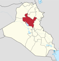
The Saladin, Salah ad Din, or Salah Al-Din Governorate (Arabic: محافظة صلاح الدين, Muḥāfaẓat Ṣalāḥ al-Dīn) is one of Iraq's 19 governorates, north of Baghdad. It has an area of 24,363 square kilometres (9,407 sq mi), with an estimated population of 1,042,200 people in 2003. It is made up of 8 districts, with the capital being Tikrit. Before 1976 the governorate was part of Baghdad Governorate.
The governorate is named after the Kurdish Muslim leader Saladin or Salah ad Din, who hailed from the governorate. This Sunni-dominated governorate is also known as the home of Saddam Hussein, who hailed from the village of Al-Awja. Salah Al-Din governorate, a traditional stronghold of Saddam and his Al-Bu Nasir tribe that is located in the heart of the Sunni Triangle, has been rocked by insurgencies, sectarian violence and tribal rivalries ever since Coalition forces invaded Iraq in 2003.[2]
Overview
[edit]
Saladin Governorate contains a number of important religious and cultural sites. Samarra, the governorate's largest city, is home to both the Al-Askari Shrine (an important religious site in Shia Islam where the 10th and 11th Shia Imams are buried), and the Great Mosque of Samarra with its distinctive Malwiya minaret. It also contains an old Zengid mosque.
Samarra was the capital of the Abbasid Caliphate in the 9th century CE, and today Abbasid Samarra is a UNESCO World Heritage Site.
The ancient Neo-Assyrian Empire Assyrian city of Assur is located in Al-Shirqat District on the banks of the Tigris River. Other sites in the governorate include the Crusader Dome (القبة الصلبية) north of Samarra and the Al-`Ashaq Palace (قصر العاشق). Today, the Saladin Governorate has a diverse population of Arabs, Kurds, Turkmens and Assyrians.
In January 2014, there were plans announced by Prime Minister Nouri al-Maliki to make the Tuz Khurmatu district into a new governorate due to its Turkmen majority.[3] However, these plans were not implemented.[4]
Autonomy
[edit]In October 2011, the governorate's administration declared itself a semi-autonomous region, explaining that the declaration was in response to the central government's "domination over the provincial council authorities".[5] Saladin, which is a largely Sunni governorate, is also hoping that by declaring themselves an autonomous region within Iraq, it will entail them to a larger portion of government funding.[5] The council cited "article 119 of Iraq's constitution" in its call for autonomy, which states that "one or more governorates shall have the right to organize into a region" if one third of the Provincial Council members or one tenth of the voters request to form a region".[6]
Provincial government
[edit]- Governor: Ammar Jabr al-Jubouri[7]
- Deputy Governor: Ammar Hikmat[8]
- Provincial Council Chairman: Ahmed Abdel-Jabbar al-Karim[7]
Districts
[edit]
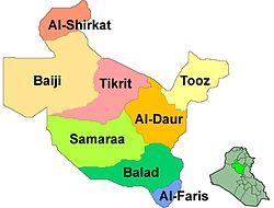
- Al-Daur District (Al-Daur)
- Al-Shirqat District (Al-Shirqat)
- Baiji District (Baiji)
- Balad District (Balad)
- Samarra District (Samarra)
- Tikrit District (Tikrit)
- Tooz District (Tuz Khurmatu)
- Dujail District (Dujail) - previously known as "Al-Faris District"
Towns and cities
[edit]- Tikrit
- Baiji
- Balad
- Samarra
- Tarmiyah
- Dujail
- Al-Daur (Ad-Dawr)
- Yathrib
- Al-Shirqat
- Sulaiman Bek
- Yankjah
- Tuz Khurmatu
- Ishaqi
- Amirli
- Azwai City (incl. Qaryat al Misḩak)
- Al Hatamia
- Al Moshahda
- Al Seniyah (Seneia Town)
- Al Alam
- Al Dhuluiya
- Al Sareen
- Al-Sedira (سّديرة)
- Al-Mu'tasim
- Al-Faris (Bamerni)
- Al-Hajaj
Population
[edit]The following table shows the populations of the districts of Saladin Governorate, according to the United Nations in 2003. No data is available for Dujail District.
| District | Samarra | Tikrit | Balad | Baiji | Al-Shirqat | Al-Daur | Tooz | Total |
|---|---|---|---|---|---|---|---|---|
| Population | 348,700 | 180,300 | 107,600 | 134,000 | 121,500 | 46,700 | 103,400 | 1,042,200 |
See also
[edit]References
[edit]- ^ "Sub-national HDI - Area Database - Global Data Lab". hdi.globaldatalab.org. Retrieved 2018-09-13.
- ^ "Iraq: No end to violence in Saddam's home province". ReliefWeb. 24 January 2007.
- ^ "Iraqi Council of Ministers approved new provinces of Tuz Khurmatu and Tal Afar". Kurd Net. 21 January 2014. Retrieved 23 August 2014.
- ^ See for example the following newspaper article from July 2015, which refers to Tuz Khurmatu as part of Saldin Governorate. "محتجون يتظاهرون في طوزخورماتو ضد القصف التركي" [Protestors demonstrate in Tuz Khurmatu]. شفق نيوز (in Arabic). Retrieved 2015-07-30.
- ^ a b Hammoudi, Laith (27 October 2011). "Saddam's home province declares regional autonomy in Iraq". McClatchy Newspapers. Archived from the original on 10 December 2011. Retrieved 4 January 2020.
- ^ "Baghdad tries to cancel demands of Diyala Province". Kurdsat TV. Archived from the original on 14 December 2011. Retrieved 15 December 2011.
- ^ a b "Iraq: Saladin governor protests Shia militia's looting". Middle East Monitor - The Latest from the Middle East. 4 April 2015. Archived from the original on 22 July 2015. Retrieved 28 July 2015.
- ^ "Fierce clashes rage around IS-held Iraqi city of Tikrit - BBC News". BBC News. 3 March 2015. Retrieved 2015-07-28.
External links
[edit]- Article and video on civilians massacre on BBC News.
- "3 U.S. soldiers charged with killing of Iraqis" on CNN.
