Salgótarján District
 From Wikipedia the free encyclopedia
Salgótarján District Salgótarjáni járás | |
|---|---|
 Flag  Coat of arms | |
 Salgótarján District within Hungary and Nógrád County. | |
| Country | |
| County | Nógrád |
| District seat | Salgótarján |
| Area | |
| • Total | 525.23 km2 (202.79 sq mi) |
| • Rank | 3rd in Nógrád |
| Population (2011 census) | |
| • Total | 64,601 |
| • Rank | 1st in Nógrád |
| • Density | 123/km2 (320/sq mi) |
Salgótarján (Hungarian: Salgótarjáni járás) is a district in north-eastern part of Nógrád County. Salgótarján is also the name of the town where the district seat is found. The district is located in the Northern Hungary Statistical Region.
Geography[edit]
Salgótarján District borders with the Slovakian region of Banská Bystrica to the north, Ózd District (Borsod-Abaúj-Zemplén County) and Bátonyterenye District to the southeast, Pásztó District to the south, Szécsény District to the west. The number of the inhabited places in Salgótarján District is 29.
Municipalities[edit]
The district has 1 urban county and 28 villages. (ordered by population, as of 1 January 2013)[1]
- Bárna (1,081)
- Cered (1,122)
- Egyházasgerge (741)
- Etes (1,429)
- Ipolytarnóc (452)
- Karancsalja (1,557)
- Karancsberény (884)
- Karancskeszi (1,905)
- Karancslapujtő (2,651)
- Karancsság (1,242)
- Kazár (1,870)
- Kisbárkány (194)
- Kishartyán (536)
- Litke (885)
- Lucfalva (631)
- Márkháza (252)
- Mátraszele (984)
- Mihálygerge (595)
- Nagybárkány (673)
- Nagykeresztúr (247)
- Rákóczibánya (677)
- Ságújfalu (1,059)
- Salgótarján (37,199) – district and county seat
- Sámsonháza (270)
- Somoskőújfalu (2,280)
- Sóshartyán (955)
- Szilaspogony (296)
- Vizslás (1,347)
- Zabar (490)
The bolded municipality is the city.
Demographics[edit]
Religion in Salgótarján District (2011 census)
In 2011, it had a population of 64,601 and the population density was 123/km2.
| Year | County population[2] | Change |
|---|---|---|
| 2011 | 64,601 | n/a |
Ethnicity[edit]
Besides the Hungarian majority, the main minorities are the Roma (approx. 5,500), Slovak (400) and German (200).
Total population (2011 census): 64,601
Ethnic groups (2011 census):[3] Identified themselves: 62,958 persons:
- Hungarians: 56,484 (89.72%)
- Gypsies: 5,383 (8.55%)
- Others and indefinable: 1,091 (1.73%)
Approx. 1,500 persons in Salgótarján District did not declare their ethnic group at the 2011 census.
Religion[edit]
Religious adherence in the county according to 2011 census:[4]
- Catholic – 30,966 (Roman Catholic – 30,846; Greek Catholic – 118);
- Evangelical – 1,182;
- Reformed – 1,136;
- other religions – 1,468;
- Non-religious – 12,682;
- Atheism – 750;
- Undeclared – 16,417.
Gallery[edit]
-
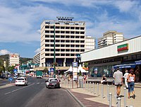 Downtown of Salgótarján
 -
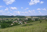 Aerial view of Kazár
 -

-

-
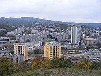 View of Salgótarján
 -
 Town Hall in Salgótarján
 -
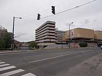
 Conferential Centre (Salgótarján)
 -
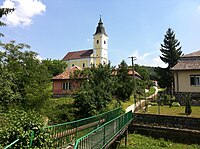 All Saints Church in Karancsberény


See also[edit]
References[edit]
- ^ A KSH 2013. évi helységnévkönyve
- ^ népesség.com, "Salgótarjáni járás népessége"
- ^ 4.1.6.1 A népesség nemzetiség szerint, 2011, (in Hungarian) [1]
- ^ 4.1.7.1 A népesség vallás, felekezet szerint, 2011, (in Hungarian) [2]
External links[edit]
| City with county rights (1) |
| |
|---|---|---|
| Villages (38) | ||
48°07′00″N 19°48′00″E / 48.1167°N 19.8000°E
This Nógrád county location article is a stub. You can help Wikipedia by expanding it. |