St. Louis Gateway Mall
 From Wikipedia the free encyclopedia
This article needs additional citations for verification. (November 2014) |
| Gateway Mall | |
|---|---|
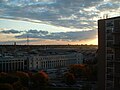
 The eastern end of the Mall seen from the top of the Gateway Arch in 2018 | |
 Gateway Mall location in downtown St. Louis | |
| Type | Civic center, sculpture garden, urban park, war memorial |
| Location | Downtown St. Louis |
| Coordinates | 38°37′41″N 90°11′57″W / 38.62806°N 90.19917°W |
| Area | 22 acres (8.9 ha) |
| Opened | 1932 (Aloe Plaza, Memorial Plaza) 1938 (Soldiers Memorial) 1939 (Luther Ely Smith Square) 1960 (Memorial Plaza Extension) 1965 (East Kiener Plaza) 1981 (Twain) 1986 (West Kiener Plaza) 2009 (Citygarden) 2022 (CityPark) |
| Operated by | City of St. Louis, Gateway Foundation |
| Status | Open year round |
| Public transit access | At 8th & Pine station |
The Gateway Mall in St. Louis, Missouri is an open green space running linearly, one block wide, from the Gateway Arch at Memorial Drive to Union Station at 20th Street. Located in the city's downtown, it runs between Market Street and Chestnut Street.
In the early 21st century, there are plans to remodel areas of the mall for additional uses and to make it more attractive to visitors. City planners hope to incorporate the many downtown locations into one mall area.
History[edit]

Early history[edit]
The Mall began as part of the Comprehensive Plan of 1907, which embraced City Beautiful principles held by members of the City Plan Commission. That plan originally called for the removal of buildings between 13th and 14th streets from Clark north to Olive streets to form a new park mall. This did not take place, and different players pushed the similar Central Traffic-Parkway plan in 1912. This intended to clear buildings between Tucker and Jefferson in a one-block-wide trip between Market and Chestnut streets. A later phase of the project would have extended the mall as far as Grand Avenue. It had the support of Mayor Henry Kiel, but in a 1915 referendum on the plan, voters defeated it.
The City Plan Commission published another downtown plan in 1919. The Public Building Plan called for the clearing of buildings for a park space between 12th and 14th streets. The first section between 12th and 13th would extend from Market north to Olive by the Central Library. The second, between 13th and 14th, would be between Market and Chestnut. This was approved by voters in 1923 with an $87 million bond to support acquisition and demolition of properties for certain spaces.
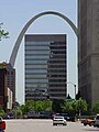
In 1939, as part of the Gateway Arch National Park (then known as the Jefferson National Expansion Memorial), a park was built with the aid of federal funds during the Great Depression between 3rd and 4th streets between Market and Chestnut.
In 1940, the city commissioned Carl Milles to design a fountain, The Meeting of the Waters, on Aloe Plaza in front of Union Station.
In the 1950s, city leaders completed the park blocks between 15th and 18th streets.
In 1965, voters approved a $2 million bond issue to build Kiener Plaza on the block between Broadway and 6th street. In 1966, voters defeated a demolition plan to extend the mall to Kiener Plaza, but the city moved forward. It secured one block between 10th and 11th streets, demolished the buildings and developed the park space in 1976. It proved unpopular, and the block was redesignated as the site of Richard Serra’s sculpture Twain .
Pride Plan[edit]
In 1982, mayor Vincent Schoemehl announced a public-private partnership called the Pride Redevelopment Corporation. The Pride plan was to remove the remaining buildings in the mall and construct smaller five-story buildings on the northern halves of each block to anchor park spaces on the southern halves. Three large historic office buildings, the Title Guarantee, Buder and International buildings, were pulled down by the end of 1984. During the two years that followed, a group of smaller historic buildings, known as Real Estate Row, were demolished, although all had been designated by the National Park Service as eligible for the National Register of Historic Places.
Only one half-block office building was constructed, the 15-story Gateway One. The building was criticized as demonstrating the very qualities it was created to replace. Its height obstructed the view of the Arch, which was supposed to be highlighted along the Mall. In addition, its mass made the section of the mall on its block seem private and inaccessible.
In 1992, Schoemehl promised to complete the Mall before he left office. In 1994, his administration cleared the two blocks between 8th and 10th streets for the mall, in the process removing the landmark Western Union Building.
Master Plan[edit]
A Master Plan was commissioned for the mall in 2007 by mayor Francis Slay. It defined the mall as a series of outside 'rooms' and promoted design of a unifying "hallway" to run along the southern edge of the mall. Each room was to serve a function related to the buildings adjacent to it. Next to the Serra sculpture, a sculpture park was called for. Next to the Library, City Hall, and the Civil Courts Building, a civic room to hold public events was recommended. Next to the Plaza Square apartment complex, a neighborhood room with family facilities was needed. At the end by Union Station, planners recommended a feature that would indicate the end of the Mall, so a terminus section was designated. These rooms were intended to interact with each other and the buildings beside them.
Citygarden, the sculpture park "room," opened in 2009 to great acclaim. It was one of the rooms called for in the Mall's master plan. Following this, a conservancy group was formed to maintain the mall, help raise money for this purpose, and carry out the rest of the objectives of the master plan.
Features[edit]
Luther Ely Smith Square[edit]

The Luther Ely Smith Square is controlled by the National Park Service, and is located directly between the Arch Grounds and the Old Courthouse. It is named after Luther Ely Smith, who organized the design competition for a landmark that resulted in selection of Saarinen's design for the Arch.
Memorial Drive, which runs along Interstate 70 between the Gateway Mall and the Gateway Arch, has often been cited by locals as having a pedestrian access problem. The current landscaping of the Smith Square, which focuses on symmetry, draws pedestrians to its edges away from its interior. It has been designated by the National Park Service as an orientation area. Under plans for renewal of the Arch area, the accessibility issue was corrected.
As winners of the 2009 international Framing a Modern Masterpiece design contest, Michael Van Valkenburgh Associates re-imagined Luther Ely Smith Square extending to form a park over Interstate 70, physically connecting the Arch grounds to the city of St. Louis for the first time. In November 2015, this plan was brought to fruition with completion of the first component of the CityArchRiver project.
To the north is the Hyatt Regency St. Louis Riverfront hotel. To the south are the Drury Plaza Hotel and KMOV-TV.
-
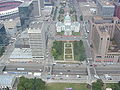 Luther Ely Smith Square as seen from the Gateway Arch

Old Courthouse[edit]

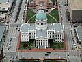
The Old St. Louis County Courthouse was a combination federal and state courthouse in St. Louis, Missouri that was Missouri's tallest habitable building from 1864 to 1894. It is now part of the Gateway Arch National Park.
Land for the courthouse was donated in 1816 by Judge John Baptiste Charles Lucas and St. Louis founder René Auguste Chouteau[1] Lucas and Chouteau required the land be "used forever as the site on which the courthouse of the County of St. Louis should be erected."[2] The Federal style courthouse was completed in 1828.
The courthouse was abandoned in 1930 by the county courts when the Civil Courts Building was built. Descendants of Chouteau and Lucas sued to regain ownership. In 1935, during the Great Depression, St. Louis voted a bond issue to raze nearly 40 blocks around the courthouse in the center of St. Louis for the new Gateway Arch National Park, which was then known as the Jefferson National Expansion Memorial. President Franklin D. Roosevelt declared in an Executive Order the area would be a national monument. The courthouse formally became part of the new monument area in 1940.
The roof was replaced in 1941. It was rehabilitated in 1955 and 1985. The courthouse remained the largest structure in the monument until the Gateway Arch was built in 1965.
Notable cases[edit]
- In 1846 slaves Dred Scott and his wife Harriet sued for their freedom in a case heard in this courthouse. Their master had held them at a military fort in the Minnesota Territory, which was free, before bringing them back with him to Missouri, a slave state. In previous freedom suits, the Missouri courts had frequently respected laws of neighboring free states and territories which ruled, "once free, always free". It had decided in favor of freedom for slaves who had been taken and held voluntarily by their masters in a free state for extended periods of time (generally a period to distinguish between through travel and residency.) All of the Scott state trials, including a Missouri Supreme Court hearing, were held in this building. Increasing tension between the North and the South on slavery resulted in the court ruling against the Scotts. The case was ultimately decided by the U.S. Supreme Court in Dred Scott v. Sandford, which ruled against him. The Court also ruled that the Missouri Compromise was unconstitutional and said that slaves had no rights under the US Constitution. This ruling polarized sides and increased tensions in the run up to the American Civil War.
- In 1872 Virginia Minor attempted to vote in a St. Louis election and was arrested, as women had not yet received the franchise. Her trials, including the deliberations before the Missouri Supreme Court, were held in the building. The case was eventually appealed to the United States Supreme Court in Minor v. Happersett, which upheld the male-only voting rules.
-
 View of the Old Courthouse from the observation area at the top of the arch. Kiener Plaza is directly behind it.
 -
 Without the Ballpark Village the Courthouse can be seen from Busch Stadium
 -


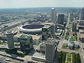
Kiener Plaza[edit]

Kiener Plaza occupies the full width of the Mall between North 7th Street and North Broadway. It sits immediately north of the Ballpark Village, developed in the early 21st century. The land is owned by Southern Real Estate and Financial Company and leased to the city of St. Louis.[3]
In 2017, renovations were completed to Kiener Plaza as part of the CityArchRiver project.
-
 Kiener Plaza as seen from the arch in 2004
 -
 The Running Man in Kiener Plaza
 -
 The Running Man
 -
 sunken section of the Kiener Plaza


Gateway One[edit]

Built in the 1980s as a replacement for three historic structures that previously occupied the mall, Gateway One was built on the northern portion of the block with a park on the southern half. The original intention was to bring economic activity to the mall with new buildings, but to keep them of moderate scale to define the northern side of the mall. Gateway One was the only building constructed in this portion. It is much taller than planned, and its mass has caused the adjoining park to take on the quality of a private plaza instead of a continued portion of the Gateway Mall. Gateway One is the headquarters of Peabody Energy. It has been criticised by many for the blandness of its design and for its obstruction of the view of the Arch. Gateway One was designed by Robert L. Boland, and completed in 1985.[4]
To the north is the Wainwright Building designed by noted 20th-century architect Louis Sullivan. To the south is 700 Market Street.
-
 View of Peabody headquarters on the Gateway Mall.

Citygarden[edit]

Citygarden is an urban sculpture park donated by the Gateway Foundation in 2009. It includes art by many famous sculptors including: Donald Baechler, Tom Claassen, Jonathan Clarke, Niki de Saint Phalle, Jim Dine, Mark Di Suvero, Jean-Michel Folon, Laura Ford, Keith Haring, Fernano Leser, Aristide Maillol, Ju Ming, Igor Mitoraj, Julian Opie, Tom Otterness, Mimmo Paladino, Martin Puryear, George Rickey, Tony Smith, Bernar Venet, Kan Yasuda, and Jack Youngerman.
Richard Serra's Twain[edit]
This sculpture by Richard Serra dominates an entire block. It was designed specifically for the location and is intended to give viewers insights and perspectives as they walk around it. It was previously located in a green square by itself, a location that did not have much pedestrian traffic. Plans are in the works to make the sculpture more accessible by the public and more connected to Citygarden.
To the north is AT&T Center and the Southwestern Bell Building. To the south is the Bank of America building and the KSDK TV and Cable Studios; south of that is the Thomas F. Eagleton Federal Courthouse.
-
![Igor Mitoraj's Eros Bendato was exhibited in Poland before being installed in Citygarden.[citation needed]](//upload.wikimedia.org/wikipedia/commons/thumb/f/f3/Igor_Mitoraj_Eros_bendato_02.jpg/90px-Igor_Mitoraj_Eros_bendato_02.jpg) Igor Mitoraj's Eros Bendato was exhibited in Poland before being installed in Citygarden.[citation needed]
Igor Mitoraj's Eros Bendato was exhibited in Poland before being installed in Citygarden.[citation needed]
![Igor Mitoraj's Eros Bendato was exhibited in Poland before being installed in Citygarden.[citation needed]](File:Igor_Mitoraj_Eros_bendato_02.jpg)
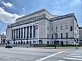
Civil Courts Building[edit]

The Civil Courts Building (sometimes referred to as the St. Louis Pyramid) is a landmark court building used by the 22nd Judicial Circuit Court of Missouri in St. Louis.
The building with its pyramid-shaped roof is frequently featured in the center of photos of the Gateway Arch from the Illinois side, as its location on the Memorial Plaza is lined up in the middle directly behind the Old Courthouse.
The building was part of an $87 million bond issue ratified by voters in 1923 to build monumental public buildings along the Memorial Plaza. These included Kiel Auditorium and the Municipal Services Building. The Plaza and the buildings were part of St. Louis's City Beautiful plan and were intended to establish a monumental center for important functions.
It replaced the Old Courthouse as the city and county court building. Its construction prompted the descendants of Auguste Chouteau, who had donated land for the courthouse, to sue to regain control of the Old Courthouse, as it was no longer being used for court purposes. They were unsuccessful.
The pyramid roof on the top was designed to resemble the Mausoleum of Maussollos, which was one of the Seven Wonders of the Ancient World. It features 32 Ionic columns (8 on each side). Each of the columns have 6 fluted drums, and a cap, and are about 42 feet (13 m) high, 51⁄2 feet in diameter. They are made of Indiana limestone.[5]
The roof is made of cast aluminum and is topped by two 12-foot (3.7 m) high sphinx-like structures with the fleur-de-lis of St. Louis adorned on their chests. These creatures were sculpted by Cleveland sculptor, Steven A. Rebeck.[6]
To the south is the Mel Carnahan Courthouse, the federal courthouse.
Memorial Plaza[edit]

Memorial Plaza is made up of nine blocks of mostly green space between Tucker Boulevard and 18th Street.[7] The first section opened between Tucker and 15th Street in 1932 and includes Eternal Flame Park, Kaufman Park, and Poelker Park. Soldiers Memorial opened on the center block in 1938 and also includes the World War II Memorial Court.[8][9] It centers the axis that frames the entrance to the Central Library to the north on Olive Street and the former Municipal Courts Building to the south on Market Street. Other notable buildings that front this section of the park include City Hall, the Stifel Theatre, and the Park Pacific Building.
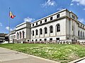
In 1960, a three block extension of Memorial Plaza opened between 15th and 18th streets with 16th Street being eliminated between Market and Chestnut streets. These blocks were lightly landscaped and the only notable feature were formations of concrete and stained glass screens located around small fountains.[10] In 1961, the Plaza Square Apartments opened bringing 1,090 units to the four blocks north of Memorial Plaza between 15th and 17th streets.[10] The St. Louis Post Office fronts this part of the park along Market Street.
According to the 2009 master plan, Memorial Plaza is to be split into a Civic Room and a Neighborhood Room. The Civic Room includes the original 1932 section and is planned to become the predominant space for outdoor festivals and events.[11] The Neighborhood Room will include the 1960 addition and is to be primarily residential in nature, with facilities like lawns, playgrounds, sand-volleyball courts, and youth soccer fields for nearby residents.[12]
-
 St. Louis City Hall in 2015
 -
 Stifel Theatre on Market Street
 -
 Central Library on Olive
 -
 St. Louis Post Office seen from Plaza Square
 -
 Memorial Plaza in 2005
 -
 Chestnut from 17th Street
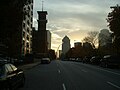


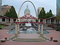
Aloe Plaza[edit]

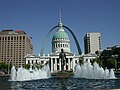
In 1923 city voters passed an $87 million bond issue that would fund public improvements, including a civic center downtown.[10] At the time city leaders felt the "slums" that fronted the city's large public buildings were a "depressing influence" on visitors to St. Louis.[13] Using funds from the bond issue the city cleared the block in front of Union Station and opened Aloe Plaza in 1932.[10] Originally the plaza was lightly landscaped with only trees around its perimeter and a circular garden in the center.[10]
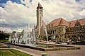
In 1940 the city added Carl Milles' fountain, the Meeting of the Waters, to the center of the block. Symbolizing the confluence of the Mississippi and Missouri rivers, two large figures represent each river and seventeen mythical creatures representing smaller tributaries adorn the fountain.[14] Initially, the fountain met some criticism for its irreverent features, particularly for the nudity of the main figures (a male figure representing the Mississippi River and a female figure representing Missouri River). Milles had named the fountain the Wedding of the Waters and conceived the seventeen smaller naked figures as a wedding party. Officials felt that a nude wedding ceremony was offensive, and insisted that the name be changed to the Meeting of the Waters.[15]
Per the 2009 master plan, Aloe Plaza is due to get some basic landscaping improvements with some additional gardens.[16] Aloe Plaza was considered part of the Mall's terminus until 2020 when the master plan was amended to include the new soccer stadium, CityPark, as the terminus.[17]
-
 St. Louis Union Station seen from Aloe Plaza
 -
 St. Louis Union Station seen from Market Street
 -
 Meeting of the Waters at Aloe Plaza
 -
 A closeup of the fountain
 -
 Meeting of the Waters figures
 -
 Meeting of the Waters
.jpg)


.jpg)
.jpg)
.jpg)
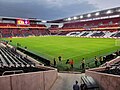
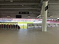
CityPark[edit]

Prior to the construction of CityPark this area consisted of highway ramps from a never built distributor highway and a small inaccessible park named the Aloe Plaza West Extension at the northwest corner of 20th and Market streets. The 2009 master plan originally proposed an observation earthwork mound for the extension, similar to the ancient mounds at Cahokia, that would have offered a view of the city.[16] Another plan from local developer, Paul McKee, would have used the reclaimed highway land as part of his Northside redevelopment.[18]
In 2020, after St. Louis had been awarded a Major League Soccer team and the stadium site was selected, the master plan was amended to include the stadium as the Mall's terminus.[17] The Market Street side of the building lines up with the center axis of the Mall facing the Civil Courts Building and the Gateway Arch.[17] The Aloe Plaza West Extenstion was incorporated into the stadium's public plazas and the Brickline Greenway along Market.
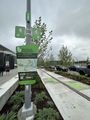
In the summer of 2024, the city is expected to break ground on the 20th Street Mobility Project which will see a shared use path constructed along 20th between the Mall and St. Louis Avenue.[19]
-
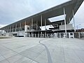 CityPark exterior
 -
 USWNT vs. Ireland at CityPark in 2023
 -
 20th and Market entrance
 -
 CityPark interior
 -
 CityPark concourse
 -
 Brickline Greenway signage along Market Street


.jpg)
.jpg)
.jpg)

References[edit]
- ^ The NPS site says the donation was from "Auguste Chouteau." Several members of the Chouteau clan have that name. It could also mean Auguste Pierre Chouteau.
- ^ Old Courthouse Architecture - nps.gov - Retrieved January 8, 2008
- ^ "32: Southern Real Estate and Financial Co". St. Louis Business Journal. American City Business Journals. March 28, 2010. Archived from the original on May 16, 2014. Retrieved July 11, 2023.
- ^ Allen, Michael R. "Building the General American Life Insurance Company Building". Preservation Research Office. Retrieved July 22, 2019.
- ^ "Civil Courts Building - St. Louis, Missouri", Waymark - waymarking.com - Retrieved January 11, 2008
- ^ Opitz, Glenn B. Dictionary of American Sculptors: 18th Century to the Present. Poughkeepsie, NY: Apollo Books, 1984, page 329.
- ^ "Memorial Plaza". stlouis-mo.gov. Retrieved April 28, 2024.
- ^ "ParkPlanning - St. Louis Soldiers' Memorial Military Museum Special Resource Study". parkplanning.nps.gov. Retrieved April 28, 2024.
- ^ "WWII Memorial Court". stlouis-mo.gov. Retrieved April 28, 2024.
- ^ a b c d e "The Evolution of the Gateway Mall (Part 4): Building the Civic Center, 1919-1960 – Preservation Research Office". Retrieved April 28, 2024.
- ^ "St. Louis Gateway Mall Master Plan" (PDF). City of St. Louis. July 2009. pp. 26–27. Retrieved April 28, 2024.
{{cite web}}: CS1 maint: url-status (link) - ^ "St. Louis Gateway Mall Master Plan" (PDF). City of St. Louis. July 2009. pp. 42–44. Retrieved April 28, 2024.
{{cite web}}: CS1 maint: url-status (link) - ^ "The Evolution of the Gateway Mall (Part 3): The Central Traffic Parkway Plan of 1912 – Preservation Research Office". January 10, 2012. Retrieved April 29, 2024.
- ^ "Meeting of the Waters Fountain". stlouis-mo.gov. Retrieved April 29, 2024.
- ^ "– Carl Milles' Meeting of the Waters in Aloe PlazaUrbanReview | ST LOUIS". www.urbanreviewstl.com. Retrieved April 29, 2024.
- ^ a b "St. Louis Gateway Mall Master Plan" (PDF). City of St. Louis. July 2009. pp. 46–49. Retrieved April 28, 2024.
{{cite web}}: CS1 maint: url-status (link) - ^ a b c Roe, Don (February 3, 2020). "Resolution for Amendment #1 of St. Louis Gateway Mall Master Plan" (PDF). City of St. Louis. pp. 7–10. Retrieved April 28, 2024.
{{cite web}}: CS1 maint: url-status (link) - ^ "– NorthSide ProjectUrbanReview | ST LOUIS". www.urbanreviewstl.com. Retrieved April 29, 2024.
- ^ "20th Street Mobility Improvements Project". stlouis-mo.gov. Retrieved April 29, 2024.